
Following the launch of trove.scot in February 2025 we are now planning the retiral of some of our webservices. Canmore will be switched off on 24th June 2025. Information about the closure can be found on the HES website: Retiral of HES web services | Historic Environment Scotland
Cruise Back Fell


Fort (Iron Age)
Site Name Cruise Back Fell
Classification Fort (Iron Age)
Canmore ID 61644
Site Number NX16SE 6
NGR NX 17943 62195
NGR Description Centre
Datum OSGB36 - NGR
Permalink http://canmore.org.uk/site/61644


- Council Dumfries And Galloway
- Parish New Luce
- Former Region Dumfries And Galloway
- Former District Wigtown
- Former County Wigtownshire
NX16SE 6 1794 6219.
(NX 1794 6219) Camp (NR)
OS 6" map (1957)
A ruinous stone fort consisting of an oval enclosure found on a small rocky plateau by a heavy stone wall and measuring internally about 50' by 40'. It is joined on the south by what can be described as an annexe, a subsidiary enclosure measuring about 80' in length. RCAHMS mention circular chambers within the walls.
R W Feachem 1963; RCAHMS 1912
Generally as described by Feachem and planned by RCAHMS. Several of the 'chambers' within the walls can still be seen but their date and purpose cannot be ascertained (some are excavation hollows). The entrance is undoubtedly in the west side of the annexe, the upper enclosure being reached from this annexe.
Resurveyed at 1/2500.
Visited by OS (RD) 8 March 1968
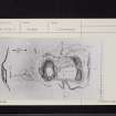
This fort is situated on the rocky knoll that forms the summit of Cruise Back Fell. Measuring 48m by 25m overall, the fort is divided into two enclosures, one occupying the summit of the knoll and the other a terrace at a lower level on the S. The upper enclosure is roughly circular, measuring about 18.5m in diameter over a wall reduced to a mound of rubble about 6m in thickness by 0.9m in height. Little of the wall is now in situ, however, and the main weight of the rubble
probably lies within the line of the inner face, a short stretch of which is visible on the ENE. On the S the wall of the lower enclosure forms a mound of rubble about 8m thick and 1.5m high, but little more than a scatter of stones remain where it runs back to meet the wall of the upper enclosure. On the E the wall rises up over a rocky spine that projects southwards from the summit and reduces the occupiable part of the enclosure. To an area measuring about 20m from N to S by 8m transversely. Below the entrance, which is on the W side of the lower enclosure, there are traces of walls enclosing a terrace on the W side of the knoll.
RCAHMS 1987, visited (SH) June 1986
Field Visit (29 September 1953)
This site was included within the RCAHMS Marginal Land Survey (1950-1962), an unpublished rescue project. Site descriptions, organised by county, are available to view online - see the searchable PDF in 'Digital Items'. These vary from short notes, to lengthy and full descriptions. Contemporary plane-table surveys and inked drawings, where available, can be viewed online in most cases - see 'Digital Images'. The original typecripts, notebooks and drawings can also be viewed in the RCAHMS search room.
Information from RCAHMS (GFG) 19 July 2013.
Measured Survey (17 July 1986)
RCAHMS surveyed the enclosures below Cruise Back Fell fort on 17 July 1986 with plane-table and self-reducing alidade at a scale of 1:500.
Note (20 December 2013 - 23 May 2016)
This fort crowns the broken summit of Cruise Back Fell, which comprises a spine of outcrop with a rocky boss on the N and another outlying outcrop on the SW. These have been linked by a thick wall, though little of it remains on the rocky spine, which forms a natural rampart on the E side of the interior. Around the lip of the boss on the N, however, it forms a mound of rubble about 6m in thickness by a maximum of 0.9m in height, while on the S, where it spans the gap between the spine and the outlying outcrop, it is up to 8m in thickness by 1.5m in height. The interior, which measures some 37m from N to S by 18m transversely (0.07ha) gives the appearance that it has been divided into two, the greater part being a terrace some 20m in length by 8m in breadth to the W of the spine, with the boss forming an upper enclosure on the N. This latter, however, is almost certainly a later sheep ree, and virtually none of the stonework visible at this end is in situ remains of the fort wall. Other parts of the wall have also been extensively robbed and reconfigured, both for the construction of another ree in the S end of the interior and to create what is probably a related enclosure taking in a lower terrace outside the fort on the W. The entrance to the fort lies midway along the W side and utilises a natural cleft in the outcrops.
Information from An Atlas of Hillforts of Great Britain and Ireland – 23 May 2016. Atlas of Hillforts SC0207
Note (25 November 2021)
The location, classification and period of this site have been reviewed and changed from FORT (PERIOD UNASSIGNED).

