
Pricing Change
New pricing for orders of material from this site will come into place shortly. Charges for supply of digital images, digitisation on demand, prints and licensing will be altered.
Balneil


Corn Drying Kiln (Medieval), Farmstead (Medieval), Field Boundary (Medieval)
Site Name Balneil
Classification Corn Drying Kiln (Medieval), Farmstead (Medieval), Field Boundary (Medieval)
Alternative Name(s) Hardcrofts
Canmore ID 61633
Site Number NX16SE 5
NGR NX 18554 64281
NGR Description Centre
Datum OSGB36 - NGR
Permalink http://canmore.org.uk/site/61633


- Council Dumfries And Galloway
- Parish New Luce
- Former Region Dumfries And Galloway
- Former District Wigtown
- Former County Wigtownshire
Field Visit (8 March 1968)
NX16SE 5 183 644.
(NX 1835 6444) Cairn (NR)
OS 6" map (1909)
A small grass-covered cairn set on the side of a slope. It measures c. 9.0m E to W by 7.0m N to S and has a maximum height of 1.7m. A hollow near the centre has revealed what appears to be a wall-face, suggesting that this feature may be an old corn-drying kiln, possibly associated with extensive field systems to the east.
Resurveyed at 1/2500.
Visited by OS (RD) 8 March 1968
Field Visit (1985 - 1986)
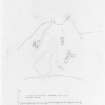
This farmstead occupies a series of low ridges on the NNW, NNE and E sides of a small lochan 650m NE of Balneil, It comprises the remains of on the NNW (NX 1849 6436) two buildings one with an adjoining structure; on the NNE (NX 1855 6435) a building and an enclosure; and on the E (NX 1855 6433) four buildings, one with an adjoining structure and another incorporating what may be an oven or kiln. A further building lies 72m to the S, and 220m to the WNW there is a kiln (NX 1855 6425 and 1835 6444 respectively).
RCAHMS 1987, visited (PC) 1985-6.
Note (9 March 2022)
The location, classification and period of this site have been reviewed and changed from CORN DRYING KILN (MEDIEVAL), FARMSTEAD (MEDIEVAL).

