
Pricing Change
New pricing for orders of material from this site will come into place shortly. Charges for supply of digital images, digitisation on demand, prints and licensing will be altered.
The Dunnan, Portankill


Promontory Fort (Iron Age)
Site Name The Dunnan, Portankill
Classification Promontory Fort (Iron Age)
Alternative Name(s) Mull Of Galloway Farm, The Dounnan
Canmore ID 61096
Site Number NX13SW 8
NGR NX 14173 32288
NGR Description Centre
Datum OSGB36 - NGR
Permalink http://canmore.org.uk/site/61096


- Council Dumfries And Galloway
- Parish Kirkmaiden
- Former Region Dumfries And Galloway
- Former District Wigtown
- Former County Wigtownshire
NX13SW 8 1417 3229.
(NX 1417 3229) Earthwork (NR)
OS 6" map (1957)
'The Dounnan'. This typical Ayrshire dun comprises an almost circular area c.39' in diameter, situated on the tip of a promonoty defended by an earthen rampart, which may have been faced with stone, as there are a few large stones scattered around the rim of the promontory. This rampart was presumably continuous, though at present it only survives on the landward side, 3' - 4' high.
Outside the rampart is a ditch 9' wide at bottom, 26' wide at top and 8' deep, cut across the neck of the promontory; some 26' to landward, separated by a level area, has been a second ditch 16' wide, while now almost concealed under whins has been yet another ditch, whose dimensions are unobtainable. There are no traces of any internal structures.
RCAHMS 1912, visited 1911; TS 25 September 1953
This work consists of the remains of an earth-and-stone rampart and two outer ditches. It measures internally c.11.5m N-S by c.12.0m transversely, and although covered by whins, no continuation of the rampart or scatter of stones around the rim of the promontory was noted. The entrance lies probably in the SE, where the rampart ends. The first ditch is as described by the RCAHMS, the second concealed by whins and heavily mutilated. The third is not at all evident and if it existed would have been in the cultivated field to the S.
The situation of this work on a promontory, coupled with the double or triple ditches and the absence of a stone enclosing wall suggest that this is not a dun but a fort typical of many found along the coastline of SW Scotland. The name could not be confirmed.
Revised at 1:2500.
Visited by OS (DWR) 7 February 1972
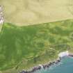
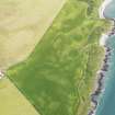
A small earthwork is situated on a steep-sided promontory of the degraded cliff-line about 150m SSE of the bay known as Portankill and 400m NNE of Mull farmhouse. On the S the earthwork is defended by two ramparts and ditches, which cut across the neck of the promontory. At its ends, the inner rampart, which measures up to 4.8m in thickness by 1.1m in height turns on to the sides of the promontory but, apart from four probable outer facing-stones on the W, there is no evidence that it completely enclosed the interior. The rampart has an external ditch measuring 7m in breadth by 1.2m in depth, and 6.5m beyond it there is a probable second ditch. The latter is about 7m broad by 0.5m deep and
has an external rampart up to 4.8m thick by 0.4m high. There is no visible evidence of a rampart between the two ditches, but the defences are obscured by dense gorse thickets. The wegde-shaped interior of the earthwork measures 12.3m from N to S by a maximum of 10.3m transversely; the position of the entrance is not clear, but may have been at the E end of the inner rampart. Traces of a third ditch have been noted on the S (R Trotter and H E Maxwell 1886) but this area has now been levelled by cultivation. The earthwork is not the remains of a dun (contra RCAHMS Survey of Marginal Lands), but it may well be a small fort of prehistoric date.
RCAHMS 1985, visited (SH) July 1984
Field Visit (24 September 1953)
This site was included within the RCAHMS Marginal Land Survey (1950-1962), an unpublished rescue project. Site descriptions, organised by county, are available to view online - see the searchable PDF in 'Digital Items'. These vary from short notes, to lengthy and full descriptions. Contemporary plane-table surveys and inked drawings, where available, can be viewed online in most cases - see 'Digital Images'. The original typecripts, notebooks and drawings can also be viewed in the RCAHMS search room.
Information from RCAHMS (GFG) 19 July 2013.
Note (20 December 2013 - 18 May 2016)
This small promontory work is situated on the coastal escarpment and on the S comprises a thick rampart with at least two external ditches, which cut off a wedge-shaped area measuring no more than 12.3m in length from N to S by 10.3m transversely (0.01ha). The inner of the ramparts, which measures up to 4.8m in thickness by 1.1m in height, turns back along the sides of the promontory and four probable outer facing-stones have been noted on the W, but there is no evidence that it completely enclosed the interior. The first of the external ditches, which lies immediately outside the rampart, measures 7m in breadth by 1.2m in depth, while the second, some 6.5m beyond it, is about 7m broad by 0.5m deep and has a counterscarp bank up to 4.8m thick by 0.4m high. There is no visible evidence of a rampart between the two ditches, nor of an additional outer ditch noted at the edge of the field in 1886 (Trotter and Maxwell 1886), traces of which Alexander Curle observed in 1911 (RCAHMS 1912, 53, No. 140), though even then obscured by the dense gorse thickets that continue to clothe the site. The position of the entrance is uncertain but may have been on the E margin of the promontory.
Information from An Atlas of Hillforts of Great Britain and Ireland – 18 May 2016. Atlas of Hillforts SC0197
Note (10 December 2021)
The location, classification and period of this site have been reviewed and changed from PROMONTORY FORT (PERIOD UNASSIGNED).

