|
Prints and Drawings |
DC 38 |
Records of the Royal Commission on the Ancient and Historical Monuments of Scotland (RCAHMS), Edinbu |
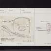
Survey plan of St Catherine's Croft, Kirkmaiden. |
5/7/1984 |
Item Level |
|
|
Photographs and Off-line Digital Images |
DC 39 P |
|
Photographic copy of survey plan. |
1984 |
Item Level |
|
|
Prints and Drawings |
DC 39 |
|
Survey plan. |
1984 |
Item Level |
|
 |
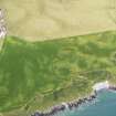
On-line Digital Images |
DP 091119 |
RCAHMS Aerial Photography Digital |
General oblique aerial view looking down the coastline towards The Dunnan promontary fort with the site of Kirkmaiden old parish church adjacent, taken from the SE. |
13/7/2010 |
Item Level |
|
 |
On-line Digital Images |
DP 091120 |
RCAHMS Aerial Photography Digital |
Oblique aerial view of The Dunnan promontary fort with the site of Kirkmaiden old parish church adjacent, taken from the E. |
13/7/2010 |
Item Level |
|
 |
On-line Digital Images |
SC 2459782 |
Records of the Ordnance Survey, Southampton, Hampshire, England |
Kirkmaiden, Old Parish Church And Burial-Ground, NX13SW 7, Ordnance Survey index card, page number 1, Recto |
c. 1958 |
Item Level |
|
 |
On-line Digital Images |
SC 2459783 |
Records of the Ordnance Survey, Southampton, Hampshire, England |
Kirkmaiden, Old Parish Church And Burial-Ground, NX13SW 7, Ordnance Survey index card, page number 2, Verso |
c. 1958 |
Item Level |
|
 |
On-line Digital Images |
SC 2459784 |
Records of the Ordnance Survey, Southampton, Hampshire, England |
Kirkmaiden, Old Parish Church And Burial-Ground, NX13SW 7, Ordnance Survey index card, Recto |
c. 1958 |
Item Level |
|
 |
On-line Digital Images |
SC 2459785 |
Records of the Ordnance Survey, Southampton, Hampshire, England |
Kirkmaiden, Old Parish Church And Burial-Ground, NX13SW 7, Ordnance Survey index card, Recto |
c. 1958 |
Item Level |
|
 |
On-line Digital Images |
SC 2459786 |
Records of the Ordnance Survey, Southampton, Hampshire, England |
Kirkmaiden, Old Parish Church And Burial-Ground, NX13SW 7, Ordnance Survey index card, Recto |
c. 1958 |
Item Level |
|
 |
On-line Digital Images |
SC 2459787 |
Records of the Ordnance Survey, Southampton, Hampshire, England |
Kirkmaiden, Old Parish Church And Burial-Ground, NX13SW 7, Ordnance Survey index card, Recto |
c. 1958 |
Item Level |
|
 |
On-line Digital Images |
SC 2459788 |
Records of the Ordnance Survey, Southampton, Hampshire, England |
Kirkmaiden, Old Parish Church And Burial-Ground, NX13SW 7, Ordnance Survey index card, Recto |
c. 1958 |
Item Level |
|
|
All Other |
551 166/1/1 |
Records of the Ordnance Survey, Southampton, Hampshire, England |
Archaeological site card index ('495' cards) |
1947 |
Sub-Group Level |
|


