
Mull Of Galloway


Earthwork (Prehistoric)
Site Name Mull Of Galloway
Classification Earthwork (Prehistoric)
Canmore ID 61051
Site Number NX13SW 17
NGR NX 14357 30732
NGR Description Centre
Datum OSGB36 - NGR
Permalink http://canmore.org.uk/site/61051


- Council Dumfries And Galloway
- Parish Kirkmaiden
- Former Region Dumfries And Galloway
- Former District Wigtown
- Former County Wigtownshire
NX13SW 17 1418 3064 to 1452 3086
(NX 1418 3064 - NX 1452 3086) Earthwork (NR)
OS 6" map (1957)
E of the road, this starts on the cliff edge as a stone-faced earthen or turf wall, 3' - 4' wide and up to 3' high, with a quarry-trench on its S side. Here it is merely a boundary wall. After a short distance the wall increases to a thickness of 6', but its construction remains the same, and it is flanked on both sides by quarry-trenches. Near the road it reaches a maximum thickness of 11' and rises to an external height of 5'6". The narrow trench at the bottom of the rear quarry-ditch is probably a later drainage ditch, upcast from which appears sporadically on the crest.
W of the road, the earthwork resumes its course on a slightly different line, so that the road was presumably already there when it was constructed. The outer mound and ditch, which were traceable at one point E of the road are now a continuous feature, but the mound is not more than 18" high, and the ditch is of slight proportions. The wall is best preserved at C, where it is 11' high externally and 5'6" above the inner ditch, which is 4' deep. This external height is rather exaggerated here by the natural slope; normally the wall averages 6' in height. The facing stones are mostly obscured, but some survive, showing that its construction is similar to that E of the road. This stage ends with a wide gap in the outer mound and ditch, and a reduction in the width of the wall facing the gap.
At D, there is the inner mound, 1' high above the interior and 5'6" above the ditch. This sector ends at another gap and reduction similar to C.
In the final sector, the mound loses its ditch and the wall is seen to be a thin and late topping-up of the earlier mound which diverges from the main work at the W end. The narrow stone wall visible in the gaps clearly also belongs to the late re-build as does the enclosure at the W end, which is probably contemporary with the narrow wall.
At E, the inner ditch is 1'9" below the crest of the wall, which is 5'6" above the outer ditch, but only 6" high internally. The outer bank is similarly only 6" high.
Though more complex than NX13SW 16, it is very doubtful if this entrenchment is defensive or of any great antiquity. It appears to be not older than the road to the lighthouse, and the outer mound, which from its alignment seem to be an integral part of the work, is of trifling size, while the stone wall is merely a boundary wall E of the road, and also in the gaps W of it.
RCAHMS TS 29 June 1955
As described. A probable 18th - 19th century field bank. Not an antiquity. Revised at 25".
Visited by OS (RD) 9 February 1972
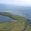
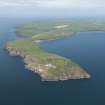
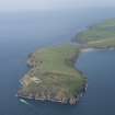
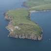
A substantial earthwork cuts off an area of about 57ha at the E end of the Mull of Galloway; it measures 400m in length and is situated 330m SSE of the earthwork (NX13SW 16) at the narrow isthmus between the bays of East and West Tarbet. In most places it comprises three ditches with medial banks, the inner bank being the larger, measuring between 3.1m and 4m in thickness with an external height of up to 2.2m. There are at least two periods of construction, however, and the inner bank is also capped by a turf dyke of relatively recent date which blocks four original gaps through the earthwork. The date and purpose of the earthwork are unknown.
NSA 1845; W Todd 1854; G Wilson 1885; NMRS, SAS 456 & 457; RCAHMS 1912; 1985, visited July 1984; RCAHMS Survey of Marginal Lands.
Field Visit (29 June 1955)
This site was included within the RCAHMS Marginal Land Survey (1950-1962), an unpublished rescue project. Site descriptions, organised by county, are available to view online - see the searchable PDF in 'Digital Items'. These vary from short notes, to lengthy and full descriptions. Contemporary plane-table surveys and inked drawings, where available, can be viewed online in most cases - see 'Digital Images'. The original typecripts, notebooks and drawings can also be viewed in the RCAHMS search room.
Information from RCAHMS (GFG) 19 July 2013.
Publication Account (1986)
Linear earthworks traverse the Mull of Galloway peninsula on either side of the narrow and low isthmus between East and West Tarbet The southern line is the longer and bigger of the two, extending over a distance of 400m from NX 145308 to 141306. For the most part it consists of three ditches with two intermediate banks, the inner and more substantial of the two banks being up to 4m broad and 2.2m high. Part of the bank is surmounted by a later turf dyke which blocks four original entrances and makes a right-angled return on top of the western cliffs.
On the opposite side of the isthmus, 330m north of its partner and immediately south of the enclosed fields, there are traces of a second earthwork reduced to a height of only 0.5m. It runs from NX 141310 to 142310 along the crest of a natural ridge and partly beneath a modem dyke; at one point there are traces of a stone revetrnent.
Interpretation of the purpose of these remains gives scope for endless speculation. The isthmus provided boat-sheltering facilities, and a portage for those who wished to avoid the strong tidal races around the point. The Mull itself is a natural citadel, but surviving evidence of man-made activities is confmed to a cairn beneath the flagstaff at NX 156304, a cup-marked rock at NX 154304, and the lighthouse (1830 AD), none of which can be equated with these defences.
Information from ‘Exploring Scotland’s Heritage: Dumfries and Galloway’, (1986).
Excavation (2000)
NX 1425 3075 (centre) An archaeological survey, geophysical survey and evaluative excavations were undertaken on two linear earthworks at the Mull of Galloway (NMRS NX 13 SW 16 and 17) to assess the extent of erosion to the site (largely by cattle).
A detailed measured survey of the earthworks was undertaken, and a vegetation survey was also carried out by the Natural Resource Consultancy. Sample geophysical survey was undertaken across the earthworks in an attempt to identify internal structural components.
Excavation was undertaken on eroded areas of both monuments and immediately adjacent areas for purposes of comparison. Four trenches were excavated: two across the inner earthwork (Trenches 1 and 2) and two across the outer (Trenches 3 and 4). The evidence of Trenches 1 and 2 demonstrated the presence of a complex monument, with the following components running from inside to out: a cobble spread; a large inner ditch; an inner rampart; a medial bank and ditch; and an outer bank and ditch. The rampart and inner ditch demonstrated at least two phases to their construction. Palisade trenches were associated with the primary phase, and both secondary castings comprised turf and earth deposits. Relative phasing between the constructions of the multiple components of the inner rampart, medial bank and ditch and outer bank and ditch could not be detected other than that the secondary recasting of the inner rampart took place after the medial ditch had been infilled.
The outer earthwork comprised a simple dump rampart along its inner length, and a stone core and dump rampart along its outer face. The excavations demonstrated that the outer rampart is considerably larger than previously thought, surviving generally c 2m high (and up to 4m where best preserved). This evidence shows that the rampart does not capitalise on a natural ridge but that the whole of this feature is artificial. How far this rampart continues to the S remains to be determined.
A report has been lodged with the NMRS (MS/1081/3)
Sponsor: Historic Scotland
R Strachan 2000.
Note (20 December 2013 - 13 December 2016)
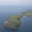
What may be the largest Iron Age enclosure in Scotland is situated on the Mull of Galloway, a large promontory some 1.7km long which forms the southernmost tip of the Rhinns of Galloway. Girt with steep slopes and cliffs, the crest of the promontory rises gently eastwards from a narrow isthmus about 20m above the shore into a low ridge at about 50m OD, descending into a shallow saddle before climbing more steeply to the broad summit of the Mull itself, where a Bronze Age cairn stands at a height of about 75m OD. Two lines of boundary works can be seen at the isthmus, each of rather different character. The first lies on the NW side of the isthmus and comprises a substantial bank some 130m long and up to 4m high, which picks up the line of the coastal escarpment flanking the landward side to block access at its narrowest point. The other adopts a position on the rising ground about 320m to the SE, with its NE end resting on the coastal escarpment overlooking the S side of the bay on the east side of the isthmus (East Tarbet), and its SW end on the cliffs forming the Mull side of a precipitous gully that cuts back into the promontory from the sea. Comprising three ditches with medial banks, it measures about 410m in length and its topographic position is clearly designed to cut off an area of at least 54ha extending eastwards to the Mull. Survey of the earthworks in 1984, suggested that there were at least three phases of construction, the most recent of which is a post-medieval turf dyke that caps the inner bank for most of its length and blocks at least two of what may have been three original gaps, dismounting at the SW end to descend to the cliff-edge at a sharp angle; it is unclear whether the line taken by the road exploits an additional entrance. Evaluation trenches cut in 2000 confirmed that the inner of the banks, which measures between 3m and 4m in thickness and stands to a maximum external height of 2.2m, was built in two phases, and also showed that in its primary phase it was associated with a palisade (Strachan 2000); what appear to be packing stones set upright in the crest of the bank were observed in one eroded sector in 2013.
Information from An Atlas of Hillforts of Great Britain and Ireland – 13 December 2016. Atlas of Hillforts SC0201
Magnetometry (1 October 2020 - 31 July 2021)
NX 0052 7325 to NZ 9725 6795 The Rhins Revealed project forms part of the Rhins of Galloway Coastal Path initiative and aims to provide outreach related to the coastal archaeology of the Rhins area, as well as training for community volunteers and baseline surveys that can assist with future condition monitoring of sites along the coastal path route.
NX 1417 3101, NX 1438 3074 A gradiometry survey was carried out at the Mull of Galloway between the western (Canmore ID: 61050) and eastern (Canmore ID: 61051) earthworks, S of the road, using a Sensys MXPDA cart-mounted gradiometry system. The results suggest the presence of circular structures in the northern end of the dataset, and a possible enclosure positioned on a low knoll near the access to East Tarbet. The data is relatively noisy however, and the results have not been confirmed by excavation.
Archive: NRHE (intended)
Funder: Rhins of Galloway Coastal Path Project, Dumfries and Galloway Council, Heritage Lottery Fund, Coastal Communities Fund
Graeme Cavers, Jamie Humble and Marta Pilarska – AOC Archaeology Group
(Source: DES Vol 22)
Note (10 March 2022)
The location, classification and period of this site have been reviewed and changed from EARTHWORK (MEDIEVAL).

