
Following the launch of trove.scot in February 2025 we are now planning the retiral of some of our webservices. Canmore will be switched off on 24th June 2025. Information about the closure can be found on the HES website: Retiral of HES web services | Historic Environment Scotland
Doon Castle, Ardwell Point


Broch (Iron Age)(Possible)
Site Name Doon Castle, Ardwell Point
Classification Broch (Iron Age)(Possible)
Canmore ID 60487
Site Number NX04SE 1
NGR NX 06702 44684
NGR Description Centre
Datum OSGB36 - NGR
Permalink http://canmore.org.uk/site/60487


- Council Dumfries And Galloway
- Parish Stoneykirk
- Former Region Dumfries And Galloway
- Former District Wigtown
- Former County Wigtownshire
NX04SE 1 06702 44683
(NX 0670 4468) Doon Castle (NAT) Broch (NR)
OS 1:10000 map (1978)
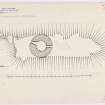
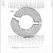
A broch situated on a narrow rocky spit cut off from the land by a wall and traversed by a ditch spanned by a built causeway. The broch, comparatively well preserved, has a normal entrance to the seaward and another, possibly secondary, to landward. The interior is about 30' in diameter within a wall about 13' in thickness.
R W Feachem 1963; RCAHMS 1912
As described by Feachem. The name 'Doon Castle' was confirmed.
Resurveyed at 1:2500.
Visited by OS (RD) 10 February 1972
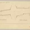
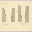
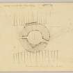
This broch is situated within an outwork on a rocky promontory on the S side of Ardwell Point. The interior of the broch, which is choked with debris, measures 9m in diameter and wall varies from 3.75m in thickness on the NNE to 4.6m on the E. The rubble of the wall stands up to 1.8m in height on the NNE and, although only occasional outer facing-stones are visible most of the inner face can be identified. There are entrances on both the NNE and the S, and a mural chamber on the E, with a probable second on the W. The NNE entrance is blocked with fallen masonry but enough of the wall face is visible to show that it measures 3.75m in length and is checked 1.8m from the outer end; the outer part of the passage is 1.4m wide and the inner part splays from 1.8m in width at the door checks to 2.2m at the inner wall-face. The S entrance had been emptied of rubble shortly before the date of visit, revealing the wall faces standing up to 1.1m in height in six courses; it measures 4.05m in length and is checked 1.25m from the outer end, the outer part of the passage contracting from 0.9m in width at the outer wall face to 0.8m between the checks; the inner passage expands from 1.2m in width at the checks to 1.4m midway along its length, before contracting to 1.1m at the inner wall-face.
All that is visible of the mural chamber on the E are the sides of the entrance, which splay from 0.8m at the mouth to 1.2m at a point about 1.2m back from the inner wall-face. The mouth of the probable W chamber is only 0.5m wide. The outwork, a wall at least 2.6m thick, encloses an area measuring 14m from E to W by 10m between the broch and the N end of the promontory. No inner fa cing-stones survive, but portions of the outer face are visible on the W, N and E ; the outer face is best preserved below the W side of the broch, where it measures 1.3m high in seven courses and was probably carried upwards by the outer face of the broch. On the E the rubble of the outwork merges with that of the broch, but again the outer face extends along the side of the promontory below the broch wall. The entrance through the outwork was probably on the NNE, opposite a causeway which has been constructed across a natural gully 6m broad and 2.3m deep that cuts off the promontory from the N. The causeway is 1.9m wide and 0.9m high, the masonry of its sides standing 0.6m high in three courses.
RCAHMS 1985, visited (SH) August 1984; Name Book 1848; RCAHMS Survey of Marginal Lands; R W Feachem 1977.
Field Visit (29 June 1955)
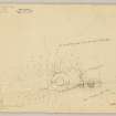
2 versions of text. Plans and details.
Publication Account (1986)
A low rocky promontory on the south side of Ardwell Point is host to the best-preserved of the small handful of brochs in western Galloway. The coastal setting is in keeping with such structures, but it is a long way from the main centres of broch-building in northern and north-western Scotland. However, like the outliers in the central Lowlands, this group does not necessarily reflect a process of migration and colonisation by broch-using peoples; they are more likely to represent the employment by local chieftains, perhaps fearful of Roman military strength, of a class of itinerant broch engineers.
Compared to some of the mighty drystone towers in the north,the best of the Galloway brochs is a muchreduced specimen, but the essential outlines of its circular design and structural features are clear enough. The interior measures 9m in diameter with walls 4.6m in maximum thickness and 1.8m in greatest heighti below this level the entire course of the inner wall-face is still visible. It has been built of large squarish blocks, and at least two cells have been set within the thickness of the wall. There are entrances to seaward and to landward, where the site has been further defended by a transverse wall and a natural gully which is spanned by a stone-faced causeway.
Information from ‘Exploring Scotland’s Heritage: Dumfries and Galloway’, (1986).
Publication Account (2007)
NX04 1 ARDWELL POINT (‘Doon Castle’)
NX/0670 4468
This probable broch in Stoneykirk stands on a low sea promontory – about 7.6m (25 ft) above the water – to the south side of Ardwell Point: visited in 1967 and 1989). A natural trench crosses this peninsula about half way along it, and some 24.4m (80 ft) from the land, and a roadway or causeway has been built across this. The circular building has an overall diameter of 17.1m - 17.7m (56 - 58 ft) with a wall which varies from 3.75m in thickness on the north-north-east to 4.6m on the east; it is built of large, roughly squared blocks packed with small angular fragments [2].
The rubble of the wall stands up to 1.8m in height on the north-north-east and, although only occasional outer facing-stones are visible, most of the inner face can be identified. The central court, full of debris, measures 9m in diameter. There are entrances on both the north-north-east and the south, with a mural chamber on the east, and with a probable second on the west.
The south entrance, facing along the shore, has been emptied of rubble and appears to be the original one. Its wallfaces stand up to 1.1m in height in six courses and it measures 4.05m in length; the door-frame, consisting of built and rebated checks, is 1.25m from the outer end. The outer part of the passage contracts from 0.9m in width at the outer wallface to 0.8m between the checks; the inner passage expands from 1.2m in width at the checks to 1.4m midway along its length, before contracting to 1.1m at the inner wallface.
The entrance on the north-north-east is wider and wedge-shaped, and at both his visits the author thought that its floor was at wallhead level and clearly secondary. Its left wall may breach an intra-mural gallery but the evidence is not clear. This passage is blocked with fallen masonry but enough of the wallface is visible to show that it measures 3.75m in length. An earlier observer gave the width of the outer part as 1.4m but the inner part is much wider. That observer also saw door-checks 1.8m from the outer end and the author saw a possible one on the left in 1967. The inner part of the passage was said to have splayed from 1.8m in width at the door-checks to 2.2m at the inner wallface, and this agrees with the author’s 1967 observation that the passage is wedge-shaped. The author’s field notebooks for the two visits have sketch plans which show the wider entrance at about 12 o’clock and show it as at least half as wide again as the south passage.
All that is visible of the mural chamber on the east are the sides of its doorway, which splay from 0.8m at the mouth to 1.2m at a point about 1.2m back from the inner wallface. The doorway to the probable west chamber is only 0.5m wide.
There is an outwork wall at least 2.6m thick, enclosing an area measuring 14m from east to west by 10m between the broch and the north end of the promontory. No inner facing-stones survive, but portions of the outer face are visible. The entrance through this wall was probably on the north-north-east, opposite the causeway mentioned earlier.
Sources: 1. NMRS site no. NX 04 SE 1: 2. RCAHMS 1912, 152, no. 433: 3. RCAHMS 1985b, 19, no. 98: 4. Stell 1986, 128, no. 53.
E W MacKie 2007
Note (1 May 2014 - 1 November 2016)
The broch on Ardwell Point stands on a promontory that is also protected by a wall drawn across the narrow neck on the N. While generally regarded as an outwork to the broch, there remains the possibility that this is also the remains of an earlier promontory enclosure, though it is by no means inaccessible from its flanks. The wall is at least 2.6m thick, forming a stony scarp on the N, where it faces into a natural gully some 6m broad and 2.3m deep. To either side it turns back southwards towards the broch and while no inner facing-stones are visible, the line of the outer face can be traced along both flanks, on the W standing 1.3m high in seven courses and probably once carried upwards by the outer face of the broch; it was thus possibly no more than a small defended annexe in front of the main entrance to the broch. Nevertheless, this wall also cuts off a much bigger area measuring about 65m from N to S by a maximum of 14m transversely (0.1ha). The presence of a second entrance in the broch giving access to the seaward end of the promontory certainly indicates that this area was also used in conjunction with the interior of the broch. The easiest line of approach to the promontory has always been from the N, and a causeway 1.9m wide and 0.9m high has been constructed across the gully at its neck.
The broch itself measures 9m in diameter within a wall that varies between 3.75m and 4.6m in thickness, and is notable for having two opposed entrances.
Information from An Atlas of Hillforts of Great Britain and Ireland – 01 November 2016. Atlas of Hillforts SC0787
Project (1 October 2020 - 31 July 2021)
NX 0052 7325 to NZ 9725 6795 The Rhins Revealed project forms part of the Rhins of Galloway Coastal Path initiative and aims to provide outreach related to the coastal archaeology of the Rhins area, as well as training for community volunteers and baseline surveys that can assist with future condition monitoring of sites along the coastal path route. As part of this project, several surveys were carried out between 2019 and 2021 including topographic surveys and drone photography and photogrammetry at Dunman (Canmore ID: 60438), Caspin (Canmore ID: 60923) and Kirklauchline (Canmore ID: 60642) forts; hut circles at Cairnmon Fell (Canmore ID: 60485) and at Castle Ban motte (Canmore ID: 65434). A resistivity survey was carried out over the upper surface of Castle Ban; the results suggest the presence of stone structures not visible at ground level.
NX 1417 3101, NX 1438 3074 A gradiometry survey was carried out at the Mull of Galloway between the western (Canmore ID: 61050) and eastern (Canmore ID: 61051) earthworks, S of the road, using a Sensys MXPDA cart-mounted gradiometry system. The results suggest the presence of circular structures in the northern end of the dataset, and a possible enclosure positioned on a low knoll near the access to East Tarbet. The data is relatively noisy however, and the results have not been confirmed by excavation.
NX 06702 44683 At Doon Castle (Canmore ID: 60487), a promontory fort containing a broch-like stone roundhouse, topographic survey and 3D laser scanning were carried out in advance of conservation works planned for a later stage of the project.
NX 0324 6902 A high-resolution 3D model was produced of the Kilmorie Stone, Kirkcolm (Canmore ID: 60731) using photogrammetry, and the results presented online.
Archive: NRHE (intended)
Funder: Rhins of Galloway Coastal Path Project, Dumfries and Galloway Council, Heritage Lottery Fund, Coastal Communities Fund
Graeme Cavers, Jamie Humble and Marta Pilarska – AOC Archaeology Group
(Source: DES Vol 22)
Conservation (June 2022)
NX 067 446 A programme of consolidation work was undertaken at Doon Castle Broch, in June 2022, as part of the Rhins Revealed Community Archaeology Project, delivered as part of development work on the Rhins of Galloway Coast Path.
Doon Castle Broch is one of the most significant prehistoric settlements on the Rhins Peninsula in SW Dumfries and Galloway. The broch most likely occupies the site of an earlier promontory fort. The aim of the project was to improve accessibility, condition and ‘legibility’ of the broch through the stabilisation of the surviving monument. Modern rebuilds and the upper levels of rubble filling the garth of the broch and its two entranceways were removed under archaeological excavation conditions.
Along with improving accessibility and stabilising the monument previously unrecorded features were revealed and overall the legibility of the monument was improved.
Archive: NRHE (intended)
Funder: Dumfries and Galloway Council
Jamie Humble – AOC Archaeology Group
Note (10 March 2022)
The location, classification and period of this site have been reviewed.

