
Scheduled Maintenance
Please be advised that this website will undergo scheduled maintenance on the following dates: •
Tuesday 3rd December 11:00-15:00
During these times, some services may be temporarily unavailable. We apologise for any inconvenience this may cause.
Dove Cave Head


Promontory Fort (Iron Age)
Site Name Dove Cave Head
Classification Promontory Fort (Iron Age)
Alternative Name(s) Little Float
Canmore ID 60445
Site Number NX04NE 13
NGR NX 05986 47330
NGR Description Centre
Datum OSGB36 - NGR
Permalink http://canmore.org.uk/site/60445


- Council Dumfries And Galloway
- Parish Stoneykirk
- Former Region Dumfries And Galloway
- Former District Wigtown
- Former County Wigtownshire
NX04NE 13 0598 4731.
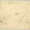
(NX 059 473). At the extreme south end of Dove Cave Head, a small fort has been formed by drawing double ramparts and ditches from edge to edge of the 150' high converging cliffs.
Excluding the rocky spine at the south end, the interior measures 90' by 60'.The ramparts, turf-covered banks and no trace of stone revetting, now measure c.15' thick at base and up to three feet high, but the outer rampart, of which only a fragment survives, presumably once occupied the full width (20') of the level space between the ditches, which themselves are 20' wide and 1'6"-2'6" deep. The entrance is near the east edge of the promontory, the gaps at the west end of the defences presumably being secondary. There is no sign of internal structures.
RCAHMS TS, 1 June 1955
As described.
Surveyed at 1/2500.
Visited by OS (RD) 9 September 1970
This fort is situated on Dove Cave Head, a steep-sided promontory on the N side of Float Bay. The N approach to the promontory is blocked by two ramparts with external ditches, which cut off an arc measuring 27.5m from N to S by 19m transversely. Although the inner rampart is 0.6m high at two points and spread up to 4.5m thick, it is generally no more than 0.3m high, and at the W end it has been entirely removed. Its accompanying ditch is now little more than a shallow scoop about 5m broad, but the cliff-section on the W shows that it is full of fine silt; only the outer lip of the ditch is well-preserved, and this forms a scarp up to 0.8m high immediately behind the outer rampart. The latter has a more regular profile than the inner rampart and expands from 3m in thickness by 0.2m in height on the W to 6m by 1.2m on the E where it terminates 7m short of the E side of the promontory; the ditch measures up to 4.8m in breadth by 0.5m in depth but peters out short of the cliff-edges on both the E and W.
The entrance is at the E end of the defences where there is a well-defined gap in the inner rampart and probably a causeway across the inner ditch; the terminals of the ditch were probably staggered, the short length of ditch 0.9m deep to the E of the causeway lying outside the line of the ditch to the W.
About 32m N of the outer ditch a section of ditch 15m in length cuts through the edge of the coastal escarpment on the W side of the promontory. The ditch measures 4.7m in breadth by 0.9m in depth and there are traces of an internal bank up to 3.5m in thickness by 0.3m in height; the bank appears to turn towards the fort along the edge of the escarpment. To the E both the bank and ditch have been obliterated and only traces of cultivation ridges and field-banks are visible.
RCAHMS 1985, visited (SH) August 1984.
Field Visit (1 June 1955)
This site was included within the RCAHMS Marginal Land Survey (1950-1962), an unpublished rescue project. Site descriptions, organised by county, are available to view online - see the searchable PDF in 'Digital Items'. These vary from short notes, to lengthy and full descriptions. Contemporary plane-table surveys and inked drawings, where available, can be viewed online in most cases - see 'Digital Images'. The original typecripts, notebooks and drawings can also be viewed in the RCAHMS search room.
Information from RCAHMS (GFG) 19 July 2013.
Reference (1957)
This site is noted in the ‘List of monuments discovered during the survey of marginal land (1951-5)’ (RCAHMS 1957, xiv-xviii).
Information from RCAHMS (GFG), 24 October 2012.
Note (20 December 2013 - 9 January 2017)
This fort occupies a steep-sided promontory on the coastal escarpment on the NW side of the mouth of Float Bay. Two sets of defences are visible cutting off the approach from the N, and probably representing separate periods of construction. The inner comprises two ramparts with external ditches, and the outer a single rampart with an external ditch. A short fragment of the latter can be seen where the ditch 4.7m in breadth by 0.9m in depth cuts obliquely into the crest of the promontory on the W, while the rampart turns S along the edge of the escarpment and forms a bank 3.5m in thickness by 0.3m in height. Elsewhere it has been ploughed flat, but the interior measures 85m from N to S by 55m transversely (0.29ha). The inner defences are better preserved, the inner rampart measuring 4.5m in thickness by up to 0.6m in height and fronted by a shallow ditch about 5m in breadth. The outer expands eastwards to a maximum of 6m in thickness by 1.2m in height at the terminal on the N side of the entrance, which lies on the E side of the promontory; its accompanying ditch is up to 4.5m broad and peters out short of the lip of the escarpment on either side. Nevertheless, the staggered configuration of the terminals of the inner ditch suggests some complexity at the entrance. The area enclosed, however, measures no more than 27.5m in length by 19m transversely (0.05ha).
Information from An Atlas of Hillforts of Great Britain and Ireland – 09 January 2017. Atlas of Hillforts SC0179
Note (10 December 2021)
The location, classification and period of this site have been reviewed and changed from PROMONTORY FORT (PERIOD UNASSIGNED).

