Castle Ban
Motte (Medieval)
Site Name Castle Ban
Classification Motte (Medieval)
Canmore ID 60368
Site Number NW96NE 3
NGR NW 96598 67823
NGR Description Centre
Datum OSGB36 - NGR
Permalink http://canmore.org.uk/site/60368
- Council Dumfries And Galloway
- Parish Kirkcolm
- Former Region Dumfries And Galloway
- Former District Wigtown
- Former County Wigtownshire
NW96NE 3 9659 6781.
(NW 9659 6781) Castle Ban (Earthwork) (NR)
OS 6" map (1957)
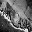
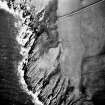
A motte (R W Feachem 1956) consisting of a green knoll projecting from the face of the 'heugh'.
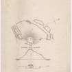
To landward at its north point a neck some 18ft in length and 9ft in breadth connects it with the top of the 'heugh'. From this neck southward, opening on to the 25ft level above the shore, a natural ravine has been hollowed out to a width of 40ft, with a depth increasing from 8ft at the neck to 13ft at its termination. On the line of the 'heugh' a mound some 20ft in thickness at base crowns the counterscarp of this trench, and 8ft in front of it there is an indication of another outwork.
The summit of the knoll, irregularly circular, measures some 75ft in diameter, and shows surface indications of building, but insufficient to determine its character. Its height above sea-level is 75ft.
Some 15ft below the summit on the NNE there is a mound from which a wall appears to run down the slope towards a rock at the end of a small creek, while, from a platform on the SW, flanking the inner side of the end of the ditch, a similar wall has descended the slope in that direction to a rock at the side of another creek, and is thence continued southward across the creek.
The mound and platform from which these walls descend are connected seemingly around the seaward side of the hillock, some 20ft below the summit, by a ledge which may have carried a wall, as large flat stones are visible here and there along its course.
There is no water on the hillock, but a burn flows into the sea about 100 yds to the southward.
RCAHMS 1912; G Wilson 1885
This motte is generally as described by the Commission except for the following observations: (1) the mound on the counterscarp of the ditch is due to ploughing being carried up to the edge of the 'heugh'; (2) the mutilated area of earthen mounds near the 'causeway' is probably upcast from the ditch; (3) the walls described by the Commission as running NNE and SW from the mound are not contemporary but are the footings of modern dykes, while the ledge or terrace round the seaward side of the mound, c.20ft below its summit, has now almost entirely disappeared due to earth-slip.
The name 'Castle Ban' is correct.
Revised at 25".
Visited by OS (WDJ) 16 February 1968
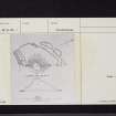
This motte has been fashioned from a promontory on the degraded cliff line 1km ENE of Mains and Airies farmhouse; it stands to a height of 11.5m on the W and 4.8m on the E, and its oval summit measures 23m by 20m. It is cut off from the cliffline by a ditch (12m broad, 3.3m deep and accompanied by the remains of a counterscarp bank) crossed on the N by a causeway (3.3m broad); a terrace continues the line of the ditch around the W side of the motte.
G Wilson 1885; R W Feachem 1955; RCAHMS 1912; 1985, visited September 1984
Field Visit (14 July 1953)
This site was included within the RCAHMS Marginal Land Survey (1950-1962), an unpublished rescue project. Site descriptions, organised by county, are available to view online - see the searchable PDF in 'Digital Items'. These vary from short notes, to lengthy and full descriptions. Contemporary plane-table surveys and inked drawings, where available, can be viewed online in most cases - see 'Digital Images'. The original typecripts, notebooks and drawings can also be viewed in the RCAHMS search room.
Information from RCAHMS (GFG) 19 July 2013.
Note (30 November 2021)
The location, classification and period of this site have been reviewed.


