Lowries Knowes
Enclosure(S) (Period Unassigned), Fort (Iron Age), Rig And Furrow (Medieval) - (18th Century), Settlement (Medieval) - (18th Century)
Site Name Lowries Knowes
Classification Enclosure(S) (Period Unassigned), Fort (Iron Age), Rig And Furrow (Medieval) - (18th Century), Settlement (Medieval) - (18th Century)
Canmore ID 59796
Site Number NT86NE 4
NGR NT 8537 6970
Datum OSGB36 - NGR
Permalink http://canmore.org.uk/site/59796
- Council Scottish Borders, The
- Parish Coldingham
- Former Region Borders
- Former District Berwickshire
- Former County Berwickshire
NT86NE 4 8537 6970.
(NT 8537 6970) Fort and Enclosures (NR)
OS 1:10,000 map, (1976).
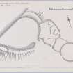
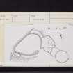
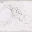
This fort and enclosures occupy the highest point of Lowries Knowes. They are generally as planned by the RCAHMS (RCAHMS Marginal land survey 29 July 1952). The ramparts of the fort exist generally as slight stony mutilated mounds, while the enclosures to the SE are formed in general by stony banks some 0.6m high.
The northernmost enclosure appears to have obliterated the outer rampart of the fort, utilising the inner rampart as its NW side.
Surveyed at 1:2500.
Visited by OS (WDJ) 23 February 1966.
This fort occupies a rocky knoll (approximately 200m OD) about 55m SSW of Dowlaw; pear-shaped on plan, it measures 55m by 37m within a heavily-robbed wall spread up to 6.3m in thickness with an entrance on the SSE. There is an outer rampart on the NE, S and SW, but on the E all traces of it have been removed by a later, irregularly- shaped enclosure. A circular enclosure 23m in diameter within a stony bank 2.7m thick lies 12m to the SE; a rectangular building-platform measuring 14.8m by 4.5m lies on its E side.
RCAHMS 1980, visited 1979.
Field Visit (29 July 1952)
This site was included within the RCAHMS Marginal Land Survey (1950-1962), an unpublished rescue project. Site descriptions, organised by county, are available to view online - see the searchable PDF in 'Digital Items'. These vary from short notes, to lengthy and full descriptions. Contemporary plane-table surveys and inked drawings, where available, can be viewed online in most cases - see 'Digital Images'. The original typecripts, notebooks and drawings can also be viewed in the RCAHMS search room.
Information from RCAHMS (GFG) 19 July 2013.
Reference (1957)
This site is noted in the ‘List of monuments discovered during the survey of marginal land (1951-5)’ (RCAHMS 1957, xiv-xviii).
Information from RCAHMS (GFG), 24 October 2012.
Note (11 February 2016 - 1 June 2016)
This fort occupies the summit of the Lowries Knowes, which falls away in a rocky face over 10m high along its NW flank. Pear-shaped on plan, it measures 55m from ENE to WSW by a maximum of 37m transversely (0.17ha) within a heavily robbed wall reduced to a bank of rubble spread between 2.6m and 6.3m in thickness; robber trenches visible in the rubble suggest it was about 3m in thickness in the vicinity of the entrance on the SE. In addition to this wall, which forms a continuous circuit, a concentric outer rampart has been drawn around the more accessible sides on the NE, SE and SW, though for the most part it has been reduced to little more than a stony scarp and on the ESE it has been obliterated by the construction of a later enclosure, probably part of a medieval or post-medieval farmstead, which rides up onto the inner rampart. The rocky interior is featureless.
Information from An Atlas of Hillforts of Great Britain and Ireland – 01 June 2016. Atlas of Hillforts SC4093
Sbc Note
Visibility: This is an upstanding earthwork or monument.
Information from Scottish Borders Council


