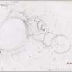
|
Prints and Drawings |
BWD 7/1 |
Records of the Royal Commission on the Ancient and Historical Monuments of Scotland (RCAHMS), Edinbu |
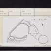
Inked plan: fort at Lowries Knowe. |
c. 1952 |
Item Level |
|
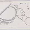
|
Prints and Drawings |
BWD 7/2 |
Records of the Royal Commission on the Ancient and Historical Monuments of Scotland (RCAHMS), Edinbu |
Plane-table survey: fort at Lowries Knowe. |
29/7/1952 |
Item Level |
|
|
Photographs and Off-line Digital Images |
DC 37 P |
Records of the Border Burghs Archaeological Project, Scottish Borders, Scotland |
Photographic copy of survey plan, ink, cslae 1:200 and drawn as part of Borders Architects Group project. |
1984 |
Item Level |
|
|
Manuscripts |
MS 36/172 |
Records of the Royal Commission on the Ancient and Historical Monuments of Scotland (RCAHMS), Edinbu |
Field notebook of K A Steer (RCAHMS). 'S5 - Berwick, Lothians, Fife', and others. |
28/8/1950 |
Item Level |
|
 |
On-line Digital Images |
DP 148089 |
Records of the Royal Commission on the Ancient and Historical Monuments of Scotland (RCAHMS), Edinbu |
Plane-table survey: fort at Lowries Knowe. |
29/7/1952 |
Item Level |
|
 |
On-line Digital Images |
DP 148090 |
Records of the Royal Commission on the Ancient and Historical Monuments of Scotland (RCAHMS), Edinbu |
Inked plan: fort at Lowries Knowe. |
c. 1952 |
Item Level |
|
 |
Digital Files (Non-image) |
WP 000762 |
Records of the Royal Commission on the Ancient and Historical Monuments of Scotland (RCAHMS), Edinbu |
Scanned copy of RCAHMS Marginal Land Survey unpublished typescripts (Berwickshire). |
1950 |
Item Level |
|
 |
On-line Digital Images |
SC 2457271 |
Records of the Ordnance Survey, Southampton, Hampshire, England |
Lowries Knowes, NT86NE 4, Ordnance Survey index card, page number 1, Recto |
c. 1958 |
Item Level |
|
 |
On-line Digital Images |
SC 2457272 |
Records of the Ordnance Survey, Southampton, Hampshire, England |
Lowries Knowes, NT86NE 4, Ordnance Survey index card, page number 2, Verso |
c. 1958 |
Item Level |
|
 |
On-line Digital Images |
SC 2457273 |
Records of the Ordnance Survey, Southampton, Hampshire, England |
Lowries Knowes, NT86NE 4, Ordnance Survey index card, Recto |
c. 1958 |
Item Level |
|
 |
On-line Digital Images |
SC 2457274 |
Records of the Ordnance Survey, Southampton, Hampshire, England |
Lowries Knowes, NT86NE 4, Ordnance Survey index card, Recto |
c. 1958 |
Item Level |
|
|
All Other |
551 166/1/1 |
Records of the Ordnance Survey, Southampton, Hampshire, England |
Archaeological site card index ('495' cards) |
1947 |
Sub-Group Level |
|


