|
All Other |
MS 731/17 |
Records of the Royal Commission on the Ancient and Historical Monuments of Scotland (RCAHMS), Edinbu |
Afforestable Land Survey field database (Rogart survey, 1995). Held as attribute table in GIS and in Oracle Field/AP table. Please see DX001425 |
1995 |
Item Level |
|
 |
On-line Digital Images |
SC 1906995 |
Papers of James Sloan Bone, landscape historian, Inverness, Highland, Scotland |
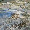
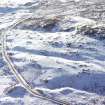
An oblique aerial view of Cnoc Dubh, East Langwell, Rogart, Sutherland, looking NE. |
2001 |
Item Level |
|
 |
On-line Digital Images |
SC 1945715 |
Papers of James Sloan Bone, landscape historian, Inverness, Highland, Scotland |
Aerial view of Cnoc Dubh hut circles & cairnfield, East Langwell, Strath Fleet, E Sutherland, looking SSE. |
2000 |
Item Level |
|
|
Digital Files (Non-image) |
DX 001425 |
Records of the Royal Commission on the Ancient and Historical Monuments of Scotland (RCAHMS), Edinbu |
RCAHMS Structures Database - Rogart |
1995 |
Item Level |
|
|
Digital Files (Non-image) |
TM 000355 |
Records of the Royal Commission on the Ancient and Historical Monuments of Scotland (RCAHMS), Edinbu |
Zip file containing all survey linework collected during the RCAHMS Afforestable Land Survey of the Rogart area 1995. |
1995 |
Item Level |
|
 |
On-line Digital Images |
SC 2348545 |
Records of the Ordnance Survey, Southampton, Hampshire, England |
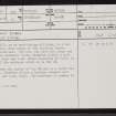
Cnoc Dubh, NC70NW 55, Ordnance Survey index card, page number 1, Recto |
c. 1958 |
Item Level |
|
|
Digital Files (Non-image) |
TM 002205 |
Records of the Royal Commission on the Ancient and Historical Monuments of Scotland (RCAHMS), Edinbu |
Zip file containing all survey linework collected during the RCAHMS Afforestable Land Survey of the Rogart area 1995. SHP and Geojson file formats with extra attribution added to the linework. |
1995 |
Item Level |
|
|
All Other |
551 166/1/1 |
Records of the Ordnance Survey, Southampton, Hampshire, England |
Archaeological site card index ('495' cards) |
1947 |
Sub-Group Level |
|


