
Cockburn Law


Building (Medieval) - (18th Century), Settlement (Prehistoric)
Site Name Cockburn Law
Classification Building (Medieval) - (18th Century), Settlement (Prehistoric)
Canmore ID 58591
Site Number NT75NE 3
NGR NT 76914 59697
NGR Description Centre
Datum OSGB36 - NGR
Permalink http://canmore.org.uk/site/58591


- Council Scottish Borders, The
- Parish Duns
- Former Region Borders
- Former District Berwickshire
- Former County Berwickshire
NT75NE 3 7691 5969
See also NT75NE 2.
(NT 769 596). An oval enclosure, 222ft by 99ft, lies about 150 yds S of the site described on NT75NE 2; the enclosing mound is 3ft high and 17ft broad. The enclosure is divided into three portions and within it there are seven circles, from 15ft to 27ft in diameter.
RCAHMS 1915, visited 1908.
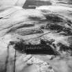
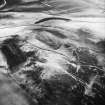
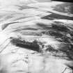
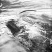
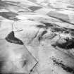
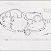
NT 7691 5969. A settlement, comprising an earth-and- stone bank averaging 3.5m wide and 1.2m high which encloses an oval area 70.0m by 30.0m, within which there are six hut circles, with a seventh outside the enclosure on the NE, situated in a non-defensive position at the foot of a slope. Two cross walls divide the enclosure. The entrance, in the SE, is well-defined and measures 2.4m wide.
Surveyed at 1:2500.
Visited by OS (RD) 12 August 1970.
No change to the previous information.
Surveyed at 1:10,000.
Visited by OS (BS) 31 May 1979.
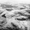
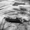
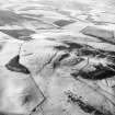
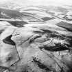
This complex settlement is situated on a level shelf on the E flank of Cockburn Law; it is probably multi-period in construction, finally measuring about 70m by 32m within an irregular wall spread up to 2.5m in thickness.
The interior is divided into three parts, each of which contains a circular house and a slightly scooped forecourt; there are various other structures within the interior, and a fourth house is recessed into the enclosure wall on the E.
Immediately to the NE there are the remains of two rectangular buildings and an area of rig-and-furrow cultivation. One of the buildings, which abuts the wall of the settlement, measures 13.9m by 3.4m within a wall now reduced to a foundation course of large stones, while the other measures 15.3m by 3m within a wall of lighter construction; both are divided into two compartments.
RCAHMS 1980, visited 1979.
Field Visit (8 August 1908)
121. Hut Circles and Small Cairns, Cockburn Law. [NT75NE 2]
On the slope of Cockburn Law, some 500 yards east of the summit and 140 yards from the edge of the cultivated land, lie the foundations of some seven hut circles measuring from 12 to 16 feet in diameter, and two small cairns of stone of similar dimensions overgrown with grass.
Another similar foundation lies about ½ mile west-south-west of the summit of the Law.
Enclosure. [NT75NE 3]
An oval enclosure, 222 feet by 99 feet, lies about 150 yards south of No. 121. The enclosing mound measures some 17 feet wide by 3 feet in height, and consists of earth and stones derived from the interior of the enclosure, which is hollowed out to a considerable extent. Two transverse mounds divide the enclosure into three portions, of which the central is the largest. In the interior are seven circles, measuring from 15 to 27 feet in diameter.
RCAHMS 1915, visited 8th August 1908.
OS Map: Ber., x. SW.
Field Visit (25 June 1953)
SETTLEMENT, COCKBURN LAW.
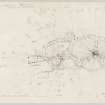
A brief description of this site is given (Revised edition No. 121) in the Inventory of Berwickshire , but in view of the fact that it is a typical, and comparatively well-preserved, example of the kind of native settlement which was current in the Votadinian region during the second and third centuries AD, it seems desirable to publish a more detailed account accompanied by a plan [DP148034]. Standing on a flattish shelf on the E. flank of Cockburn Law, 400 yds, from the summit and at a height of 850 ft. OD, the settlement takes the form of an enclosure, measuring 230 ft. in length by 105 ft. in greatest breadth, which is bounded by a ruined boulder faced rubble wall originally about 8 ft. thick. Most of the facing stones of the wall have long since been removed, but the core still stands to a height of 3 f t. in places. The interior of the enclosure is sub-divided by two cross-walls into three compartments, each of which has an entrance in the E. side of the enclosure wall, while a gap in either cross-wall allows direct communication between one compartment and the next. Each compartment contains a forecourt, slightly excavated below the natural ground level, and a well-defined hut which is situated at the rear of the forecourt and opens on to it. The hut walls were originally faced with stone and measured about 4 ft. in thickness, but they have been heavily robbed; two of the huts (1 and 3 on the plan) are circular with internal diameters of 20 ft. and 25 ft. respectively, whereas the other (2) is oval and measures 20 ft. by 15 ft. internally. A fourth hut also 20 ft. in internal diameter, would seem to be somewhat later in date than those already described, since it is partly recessed into the outer face of the enclosure wall on the E. In addition, there are three minor structures, two (5 and 6) in the N. compartment and one (7) in the S. compartment, which may either be the remains of huts or of ancillary buildings; the pair in the N. compartment appear to be original features, but the other (7) , which consists of a slight scoop partly enclosed by a wall, may be secondary since two of the facing stones employed in the wall are large orthostats probably derived from the enclosure wall. Outside the N. end of the settlement there are the foundations of two rectangular buildings of more recent origin: one of these, a two-roomed structure, is presumably a but-and-ben, and both buildings may be contemporary with the rig cultivation visible hereabouts, and which, although it avoids the buildings in question, has impinged upon, and partly obliterated, the wall of the settlement.
Visited by RCAHMS (KAS), 25 June 1953.
Note (31 January 2020)
The location, classification and period of this site have been reviewed.
Sbc Note
Visibility: This is an upstanding earthwork or monument.
Information from Scottish Borders Council

