
Following the launch of trove.scot in February 2025 we are now planning the retiral of some of our webservices. Canmore will be switched off on 24th June 2025. Information about the closure can be found on the HES website: Retiral of HES web services | Historic Environment Scotland
Hume Castle


Castle (Medieval), Folly (18th Century)
Site Name Hume Castle
Classification Castle (Medieval), Folly (18th Century)
Canmore ID 58561
Site Number NT74SW 3
NGR NT 70473 41394
Datum OSGB36 - NGR
Permalink http://canmore.org.uk/site/58561


First 100 images shown. See the Collections panel (below) for a link to all digital images.
- Council Scottish Borders, The
- Parish Hume
- Former Region Borders
- Former District Berwickshire
- Former County Berwickshire
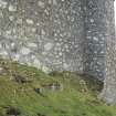
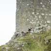
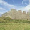
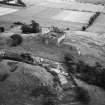
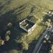
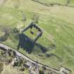
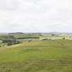
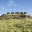
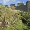
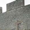
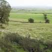
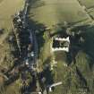
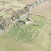
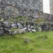
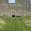
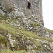
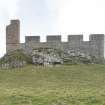
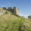
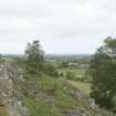
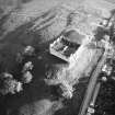
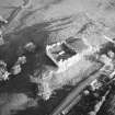
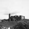
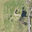
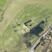
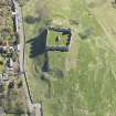
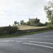
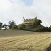
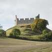
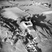
Hume Castle occupies one of the highest and most dominant sites in the region, commanding views across the Merse and towards the English borderlands. The existing structure is of largely eighteenth-century date, built around the fragmentary remains of a medieval stronghold.
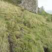
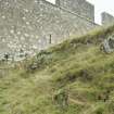
First mentioned in the twelfth century, the castle was the seat of the powerful Home family. The natural outcrop of rock on which it stood is precipitous at the north-west side, so most of its man-made defences are on the southern flanks
During the sixteenth and seventeenth centuries, the English besieged the castle no less than four times. During the first of these sieges, it was Lady Home who was required to defend her home and it only fell when the attackers began to hang her young son within her view. The castle was reportedly destroyed in 1651, after it fell to Cromwell's troops.
Though rebuilt as a folly in the eighteenth century, the castle resumed a military role during the Napoleonic wars, when it became the site of a signalling beacon. A nation-wide panic almost ensued when an accidental fire in Northumberland was spotted and misinterpreted. In World War II, an observation post was also located here.
Text prepared by RCAHMS as part of the Accessing Scotland's Past project
NT74SW 3.00 70473 41394
NT74SW 3.01 c. 704 407 Lead ball
(NT 70473 41394) Castle (NAT)
and remains of Castle (NR)
OS 6" map, (1971).
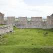
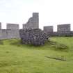
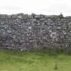
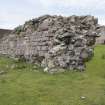
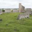
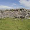
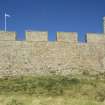
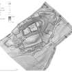
The existing ruins of Hume Castle are of comparatively recent date, having been raised on the old foundations by the Earl of Marchmont in 1794. Nothing remains of the of the ancient stronghold but the general form and extent of the outer enclosing walls, surrounding a courtyard about 130 ft square (see plan). MacGibbon and Ross note: 'In the centre of the courtyard there is a mass of ancient masonry, but it is impossible to say of what structure it formed part'. It is first recorded in the 12th century, and was demolished by Cromwell in 1651. RCAHMS 1915; D MacGibbon and T Ross 1889; S Cruden 1963; RCAHMS 1980, visited 1979.
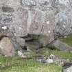
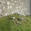
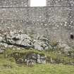
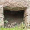
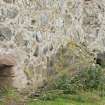
None of the original foundations of Hume Castle are visible, the 18th century walls presenting an unbroken uniform surface. The only possible remnant of the old walls is an isolated stretch in the centre of the courtyard, 8m long, 3m high and 1.5m thick. Although the N face of this wall is similar to the 19th century walls, the S face appears to be much older. It is surrounded by an irregular tumbled mass of turf-covered masonry. The well shown on plan is 1.5m in diameter and is lined with squared masonry.
Visited by OS(JFC) 24 January 1955.
Non-Guardianship Sites Plan Collection, DC23925- DC23926, 1931.
Field Visit (23 October 1908)
180. Hume Castle.
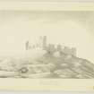
This castle stands on a rocky height some 700 feet above the sea and distant about 5 ½ miles to the north of Kelso. The existing ruins are of comparatively recent date, having been raised on the old foundations by the last Earl of Marchmont in 1794, so that nothing remains of the ancient stronghold but the general form and extent of the outer enclosing walls. On plan it has been an irregular square measuring some 130 feet within enclosing walls averaging 6 feet in thickness. There are indications of flanking towers at the south-east and south-west angles where -the nature -of the ground necessitated additional protection. On the north-westside such precautions appear to have been considered unnecessary owing to the natural protection of a rocky precipice. In the centre of the courtyard there is a rough mass of ancient masonry of which the significance is not apparent. The original castle has evidently been of the First Period with the typical walls of enceinte enclosing a large central space or courtyard strengthened where necessary with towers and occupying a naturally strong defensive site, which has commanded a wide range of border-land.
Hume Castle was the first stage in the transmission by beacons on conspicuous places of news of coming English invasion from the ‘watchers’ on the Tweed. As a fortress, however, its importance was mainly local. In September 1545 the Earl of Hertford was explaining to Henry VIII. that the castle ‘standing upon a high rock, is very strong’. He considers that in virtue of this strength it ‘could hold out for eight or ten days at least’. For this reason and also because ‘it can only hold 60 men in garrison (and but 10 of them horsemen)’, no attack was made on it at that time. It was besieged and captured by the same Hertford, when Earl of Somerset, on his return to the Merse after Pinkie-cleuch in 1547, but recovered by Alexander Lord Home two years later. In 1569 it was battered by the guns of the Earl of Sussex and again surrendered by its garrison, which is said to have numbered 240 men. After the Battle of Dunbar (1650) Cromwell found it necessary to eliminate Hume Castle as a danger to his communications, and in February 1651 the place was reduced by Colonels Fenwick and Syler after a bombardment by mortars. The strength of the place was found to lie in its vaults, and not till a ‘culverin’ made a breach in these did the garrison give in. They numbered 75 all told. The castle was then demolished.
Letters and Paper's (Henry VIII.), vol. xx. Douglas's Cromwell's Scotch Campaigns.
See Cast. and Dom. Arch., iii. p. 106 (plan and illus.).
RCAHMS 1915, visited 23rd October 1908.
OS Map: Ber., xxvii. NE.
Laser Scanning (29 July 2015 - 29 July 2015)
Laser scan data was collected by RCAHMS to enable an accurate set of interpreted building plans to be created.
Project (March 2015 - August 2018)
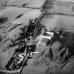
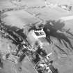
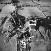
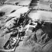
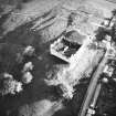
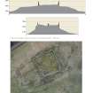
In March 2015 a UAV survey was carried out at Hume Castle, covering the castle and field immediately around it. This survey was at the request of the Hume Castle Preservation Trust who wished to learn more about the site which they had purchased. The survey was a test of the use of UAV generated low level photography to create an accurate 3D model of the castle and its surrounding landscape where there were significant issues of height difference. Cyberhawk were contracted to do the survey by RCAHMS. This included the establishment of ground control points recorded by GPS to fix the accuracy of the survey data. Overlapping imagery ensured a resolution of 3m. However, the accuracy of the 3D model of the castle folly was impaired by the lack of enough control points close to the walls of the structure and further measurements were taken with a terrestrial scanner to supplement the data. A 3D model was created with Photoscan software and interpreted by RCAHMS/HES staff through a mixture of field and desk-based observation. Visualisations of the data were prepared from which plans were drawn up at a scale of 1:1000 for the whole field covering the castle and village remains. More detailed recording of the castle was required at 1:250. This included a ground plan of the castle and folly as well as profiles of the castle mound in two directions.
Sbc Note (15 April 2016)
Visibility: Standing structure or monument.
Information from Scottish Borders Council
Note (August 2017)
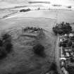
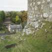
The village and church
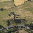
The modern hamlet of Hume occupies a rocky ridge overlooking the Merse and the English border to the south. A church and village are recorded at Hume from the mid-12th century, but direct reference to the castle does not appear until the later Middle Ages. This site is remarkable for its 18th century folly and the juxtaposition of castle and village: and not just any village but the largest deserted village in south-east Scotland. While today’s village comprises a row of twenty 19th century and modern houses along the north side of the public road through the village, in the late 17th century there were 86 houses in the village according to the Hearth tax returns.
The Hume and Greenlaw estate was granted to a son of the Earl of Dunbar in the early 13th century whose family name, Home, became eponymous with the name of the land they had acquired and was a well-known surname in the eastern borders. It is possibly from that time that a castle was built on the outcrop of rock now crowned by the fantastical castellated folly erected by the Earl of Marchmont in the late 18th century. The village was devastated in the 14th century during the Wars of Independence and cleared in the late 18th century, while the castle, fought over in the 16th and 17th centuries, was finally destroyed by Cromwell’s army in 1650.
The size of the settlement was revealed in a survey by Piers Dixon and a local team of young people in 1987. The sites of many houses and ridge and furrow cultivation was mapped that stretched from modern village for half a mile to the west on either side of the loaning that leads to the churchyard of the former parish church of St Nicholas. The church itself has been robbed of stone and can only be traced as a platform surrounded by gravestones. The village houses that were located did not stand to any great height and the walls were mostly reduced to footings or robber trenches, suggesting that the superstructure of the walls may have been of perishable material, such as clay, on a stone base.
The 1987 survey lay dormant in the local records for almost 30 years until the Hume Castle Preservation Trust acquired the site. Royal Commission on the Ancient and Historical Monuments of Scotland answered a request for help from them to interpret the site that led to a resurvey of the castle and surrounding field using a low level aerial survey by UAV in 2015 (including a video). A 3D model of the ground surface was produced from which a plan of the castle and surrounding part of the village was mapped. Within the field in which the castle stood some 25 houses and yards alone were located forming rows of properties along the hollow ways of the village streets to north and south of the castle rock. However, this is only about one third of the late 17th century village, the rest of which still lies, further to the west. On the slopes to the south of the village, two phases of ridge and furrow were revealed, with straight narrow, Improvement period ridges over curving broad ridges of medieval origin, hitherto unnoticed.
The castle
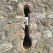
The 3D model also showed that there was a rampart on the east end of the castle rock outside the stone walls of the folly suggesting there might have been an earthwork and timber castle here, possibly dating to the 13th century. There was also an outwork of the castle on the west which can be traced from the stone footings around the squared shape of the outcrop at this end. Further indications of the early castle were shown clearly by the 3D survey to include an earlier wall outside the present west wall which included a round tower immediately in front of the present entrance and another round tower on an outcrop outside the north wall which had been invisible until the UAV survey. This evidence suggested an enclosure castle replaced the earlier earthwork in the 13th or 14th centuries, which was in turn replaced by a large tower and artillery defences in the 15th and 16th centuries, when the Homes acquired baronial status. Part of the tower still stands as a ruin inside the folly, a 15th century dumbbell gun-loop is built into the west wall and the sloping artillery defence of the south wall is of late 16th or 17th century date. The outer approach to the castle was via a ramp from the west between two robbed-out buildings, with a large terraced garden on the south, which gives a more pleasurable aspect to the castle than hitherto appreciated.
Dr Piers Dixon, Deputy Head of Survey and Recording, HES
Project (10 August 2018 - 21 August 2018)
NT 70004 40836 (Hume Old Parish Church) and NT 70469
41392 (Hume Castle) A three year project, led by the
Hume Castle Preservation Trust and working with local
volunteer groups and organisations, is being carried out
to investigate the remains of Hume Castle, the medieval
village of Hume, the former parish Church of St Nicholas,
and the surrounding landscape, in order to provide a better
understanding of the history of the sites. Over the course of
the three years a series of workshops and field seasons will
be conducted to investigate their historical background,
complete a walkover survey of the study area, conduct
a geophysical survey and graveyard survey at the former
parish church, conduct a historic building record of the
castle, and carry out excavations at key sites identified
during the survey works.
Contextualising Hume: Gravestone detail © HARP
A programme of work was undertaken 10–21 August 2018.
A walkover survey was conducted within land owned
by the Hume Castle Preservation Trust and surrounding
Hume Castle by HARP, supported by volunteers from the
local community. The walkover survey was used both as a
training opportunity, and to identify the extant remains of
sites surrounding the castle. The survey used results from
a former drone survey completed by HES to target specific
sites identified from the air. The survey identified a number
of the sites picked up by the drone, in particular a series of
house platforms and terraces relating to the former medieval
village and castle structures. Vegetation cover and terrain
made it difficult to identify all of the sites, but those that
were found could also be analysed on the ground, sometimes
suggesting different site types than previously identified.
A possible track way running around the N and E sides of
the castle was also revealed, which appears to have been
subsequently overlain by the dry stone walls of the loaning
to the E, suggesting an earlier date for the trackway. The
survey was able to highlight a number of suitable sites for
future excavation.
A graveyard survey was conducted within Hume Cemetery,
formerly housing the parish church of Hume. The graveyard
contains >100 visible memorial stones which were recorded
by plane table survey, and during 2018 survey and condition
recording were completed on 47 of the stones. A large
proportion of the stones are located within the bounds of the
former church, now visible as an earthen mound, towards
the centre of the graveyard. The earliest stone identified thus
far dates to 1717, and five of the 47 recorded stones have
been found to no longer be located in their original position.
The graveyard survey will continue in 2019.
Geophysical survey was completed within the graveyard
of the church of Hume, along with two fields located
immediately to the E, and S, which formed the glebe once
associated with the church. Within the graveyard the
geophysical results have highlighted a number of graves,
mainly marked by gravestones, and the likely foundations of
the former church. Within the footings of the church there
is evidence of possible internal divisions, while the exterior
of the church has also produced some linear anomalies
that may be representative of earlier walls of the church, or
possibly earlier boundaries of the graveyard. In the glebe
to the E there is evidence for possible pits and postholes,
possibly related to an earlier structure. Further pits have been
identified in the glebe to the S of the graveyard.
Historic building recording was conducted at Hume Castle,
with an enhanced survey taking place to record the exterior
elevations of the W, S, SE, and E-facing walls of the current
folly. The recording has been carried out in order to identify
architectural features within the castle, and to provide a
baseline record. The recording will continue in 2019 with an
aim to complete the record of the exterior elevations, and to
conduct the same level of recording on the interior elevations.
Archive and report: NRHE (intended)
Funder: Heritage Lottery Fund and Fallago Environment Fund
Website: www.contextualisinghume.co.uk
Ian Hill, Kieran Manchip, Samira Hill, Gern Midlane, Iain Pringle
and Rebecca Barclay – Heritage and Archaeological Research
Practice (HARP)
(Source: DES, Volume 19)
Laser Scanning (22 August 2018 - 24 August 2018)
Laser scan data was collected by HES to enable an accurate set of interpreted building plans to be created. This survey primarily consisted of the scans of the exterior of the castle and the surrounding area.
Test Pit Survey (19 November 2018)
NT 70513 41501 A programme of archaeological works was required during drainage works along the road through Hume village. The works extended into the Scheduled area of Hume Castle (SM 387) at their eastern extent. The watching brief revealed the remains of a crude stone surface across the entirety of the trench area representing a possible trackway or ancient road related to the castle and surrounding area. Material related to both 19th and 20th century activity was also observed during excavation. No other significant archaeological remains or small finds were discovered during the watching brief
Information from K. Wallace - AOC Archaeology Group
OASIS ID: aocarcha1-340059
Excavation (8 March 2021 - 30 August 2021)
NT 70004 40836 – NT 70469 41392 A three year project led by the Hume Castle Preservation Trust, and working with local volunteer groups and organisations, is being carried out to investigate the remains of Hume Castle; the medieval village of Hume; the former parish Church of St Nicholas; and the surrounding landscape. The aim to gain a better understanding of the history of the sites. Over the course of the three years a series of workshops and field seasons will be conducted to investigate their historical background; complete a walkover survey of the study area; conduct a geophysical survey and graveyard survey at the former parish church; conduct an historic building record of the castle; and carry out excavations at key sites identified during the survey work.
The 2020 summer field season was delayed due to the
Covid-19 pandemic, with the archaeological excavation carried out in Spring 2021 over the course of 3 weeks, and the graveyard re-assessment conducted over three days.
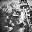
NT 70469 41392 Hume Castle (Canmore ID: 367583) Two trenches were excavated to investigate two structures within the settlement, one test-pit was excavated to investigate the potential eastern defences of the medieval castle, and two test- pits were excavated to investigate the deposits and geology to the W of the castle. Trench 1 (4 x 4 m) was located to investigate structural remains identified during previous survey work (Building 41), with a drone survey indicating a rectangular building on an approximately E–W orientation. It is located to the SW of the castle, on the northern side of a possible access route up to the castle. Whilst the trench was excavated to target an internal division, and the southern wall of the building, the uncovered remains indicated a more complex floor plan to the building. Rather than an internal division running N–S through a rectangular building, excavations in Trench 1 revealed an outer (southern) wall to the structure that possibly terminated towards the western end of the trench. Whilst erosion may have eroded the wall, it is also possible that the lack of wall remains indicates an entranceway into the building. The southern face of the wall was not revealed. The uncovered remains suggest a significant composite wall, surviving to a width of greater than 1m, with a stone (internal) face and a rubble and clay infill. To the N (interior) of this wall, a significant amount of stone collapse was identified, along with two further stone built walls, with the remains of a possible N/S wall protruding from the eastern section of the trench, and the corner of a further building, or room, indicated by an ‘L’ shaped composite stone and clay wall identified in the NW corner of the trench. The artefacts retrieved during excavations in Trench 1 indicate that the building was still in use, or at least activity was still occurring here into the 18th or 19th centuries. It is possible, therefore, that if the complex of buildings here were in use prior to the destruction of the castle, that these buildings were subsequently repurposed, or indeed reconstructed, on top of earlier structures, and continued to be used many years after the destruction of the castle.
Trench 2 (4 x 4 m) was located to investigate structural remains of a potential platform house with associated enclosure, located to the N of the NE corner of the castle. The uncovered remains largely correspond to the postulated remains identified in previous survey work. The structural remains uncovered suggest a possible wall that would correspond to the southern wall of the identified building, with three walls or partial walls representing a potential enclosure appended to the S side of this building. The nature of the artefacts suggest that this building was likely a domestic structure, with large amounts of glazed ceramic and bottle glass uncovered, also indicating that the building was in use, or there was at least activity in this part of the site, until sometime in the 19th century. Due to the proximity of this excavated area to the road and the modern village of Hume however, it cannot be discounted that some of the artefacts may be rubbish deposits, thrown over the boundary wall located just to the N. The discovery of a jetton on top of wall remains also points to earlier activity within the area, but this find alone cannot suggest that the building itself was in use during the late medieval period. At the SW corner of the trench the discovery of a series of large stones and boulders suggest the possibility of a significant wall to the S of the identified building and possible enclosure, possibly a retaining wall. Test-pit 1 was located to investigate the deposits and geology to the W of the castle, and S of the entrance gate from the castle car park. The test-pit was located on the route of a modern vehicle access track and measured 1 x 1m. Excavations in Test-pit 1 did not uncover any significant archaeological remains. The test-pit revealed bedrock outcropping only 300mm below ground surface at this part of the site, also indicating stone tumble from upslope to the E likely associated with erosion, however it cannot be ruled out that the tumbled stones may have been associated with the destruction of the castle and associated features.
Test-pit 2 was located to investigate the deposits and geology to the SW of the castle, and was located to the SW of Test-pit 1, at the western end of a possible entrance route up to the castle. The test-pit measured 1 x 1m. The topography and bedrock outcropping, creating a natural holloway at the location of Test- pit 2 suggested the possibility of a track way leading up to the SW of the castle. This was confirmed with excavation following the discovery of a metalled surface. Whilst only a small portion of the surface was uncovered in the Test-pit, it is likely that the track continues up the holloway and passes adjacent to the S of the structural remains in Trench 1, whilst also passing by a second building directly opposite to the S of the remains uncovered in Trench 1.
Test-pit 3 was located to investigate the deposits and character
of a potential defensive rampart located to the E of the castle. The test-pit measured 3 x 1m and was orientated approximately NE/SW across the potential rampart in order to characterise its construction and depth. Excavations in Test-pit 3 revealed a large number of stones that have likely tumbled down the natural slope from the W. The remains of a possible wall were recorded as running across the test-pit from the NW to SE that may correlate with the remains of a bank identified during the previous drone survey. The nature and topography of the exposed bedrock however, indicate that these stones likely came to naturally rest in a deeper area of subsoil than those further upslope, potentially acting as a natural barrier to proceeding tumble, rather than having been formally built as a wall or boundary. The remains uncovered in Test-pit 3 do not seem to indicate any evidence of castle defences, or associated boundaries, and are likely a reflection of the natural topography in this part of the site, however the amount of tumbled stone located in this area suggest that the stone deposits may relate to the destruction phase of the castle.
NT 70004 40836 Hume Old Parish Kirkyard (Canmore ID:
367583) The graveyard condition survey of the visible memorials was undertaken in the late summer of 2021, and assessed whether changes to the graveyard had occurred since the initial survey in 2018 and 2019. A graveyard condition report will follow to determine the nature and extent of the changes that have taken place at the graveyard.
Archive: NRHE
Funder: Heritage Lottery Fund and the Fallago Environment Fund
Ian Hill, Michelle Gamble and Samira Hill – Heritage and Archaeological Research Practice (HARP)
(Source: DES Vol 22)

