Following the launch of trove.scot in February 2025 we are now planning the retiral of some of our webservices. Canmore will be switched off on 24th June 2025. Information about the closure can be found on the HES website: Retiral of HES web services | Historic Environment Scotland
Hume Castle Survey


Date March 2015 - August 2018
Event ID 1102055
Category Project
Type Project
Permalink http://canmore.org.uk/event/1102055
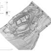
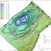
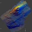
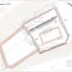
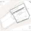
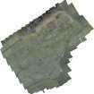
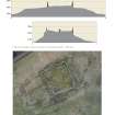
In March 2015 a UAV survey was carried out at Hume Castle, covering the castle and field immediately around it. This survey was at the request of the Hume Castle Preservation Trust who wished to learn more about the site which they had purchased. The survey was a test of the use of UAV generated low level photography to create an accurate 3D model of the castle and its surrounding landscape where there were significant issues of height difference. Cyberhawk were contracted to do the survey by RCAHMS. This included the establishment of ground control points recorded by GPS to fix the accuracy of the survey data. Overlapping imagery ensured a resolution of 3m. However, the accuracy of the 3D model of the castle folly was impaired by the lack of enough control points close to the walls of the structure and further measurements were taken with a terrestrial scanner to supplement the data. A 3D model was created with Photoscan software and interpreted by RCAHMS/HES staff through a mixture of field and desk-based observation. Visualisations of the data were prepared from which plans were drawn up at a scale of 1:1000 for the whole field covering the castle and village remains. More detailed recording of the castle was required at 1:250. This included a ground plan of the castle and folly as well as profiles of the castle mound in two directions.