
Hume, General


Settlement (Period Unassigned), Village (Medieval)
Site Name Hume, General
Classification Settlement (Period Unassigned), Village (Medieval)
Alternative Name(s) Hume Village
Canmore ID 58551
Site Number NT74SW 10
NGR NT 70502 41492
NGR Description Centred NT 70502 41492
Datum OSGB36 - NGR
Permalink http://canmore.org.uk/site/58551


- Council Scottish Borders, The
- Parish Hume
- Former Region Borders
- Former District Berwickshire
- Former County Berwickshire
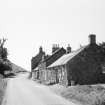
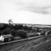
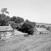
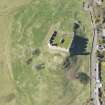
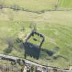
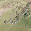
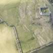
Hume village today consists of a row of buildings lining one side of the road that runs adjacent to Hume Castle. However, until the eighteenth century, it was a much larger settlement which occupied the flanks of Hume Castle and the surrounding fields.
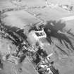
In 1987, an archaeological survey of the area recorded eleven rectangular stone buildings, all of which are now reduced to stone footings and overgrown. In addition, there were 18 scooped and terraced areas on which further buildings once stood.
Hume Castle was once the seat of the powerful Home family and an important Border stronghold until the seventeenth century. Although the remains that are visible today date from the last period of the village's occupation, it is probable that a settlement lay here from the time of the castle's construction in the twelfth century.
Text prepared by RCAHMS as part of the Accessing Scotland's Past project
NT74SW 10 704 413.
Though the village of Hume now only consists of a single row of cottages, in ancient times it was of considerable extent, the houses extending as far as the present churchyard (NT 700 407), while others surrounded the castle (NT74SW 3, at NT 704 413).
Name Book 1858.
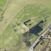
NT 704 413. Around the flanks of the rocky hillock on which Hume Castle stands, and in the pasture field immediately to the SW, there are remains of eleven rectangular stone buildings and eighteen rectilinear scoops and terraces, the majority of which may indicate the sites of houses. There was a large village at Hume in the mid-18th century and while many of these remains are probably of this date, some are likely to be earlier.
RCAHMS 1980, visited 1979.
Field Visit (1982 - 1988)
The Manpower Services Commission funded Border Burghs Archaeology project (sponsored by Borders Architects Group) carried out excavations in the burghs of the region, created the Sites and Monuments Record for Borders Region and carried out field survey in support, including plane table surveys of selected sites under the direction of Dr Piers Dixon.
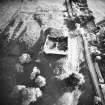
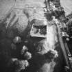
Project (March 2015 - August 2018)
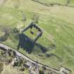
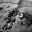
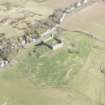
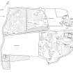
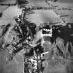
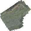
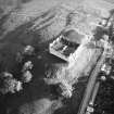
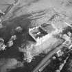
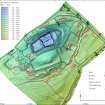
In March 2015 a UAV survey was carried out at Hume Castle, covering the castle and field immediately around it. This survey was at the request of the Hume Castle Preservation Trust who wished to learn more about the site which they had purchased. The survey was a test of the use of UAV generated low level photography to create an accurate 3D model of the castle and its surrounding landscape where there were significant issues of height difference. Cyberhawk were contracted to do the survey by RCAHMS. This included the establishment of ground control points recorded by GPS to fix the accuracy of the survey data. Overlapping imagery ensured a resolution of 3m. However, the accuracy of the 3D model of the castle folly was impaired by the lack of enough control points close to the walls of the structure and further measurements were taken with a terrestrial scanner to supplement the data. A 3D model was created with Photoscan software and interpreted by RCAHMS/HES staff through a mixture of field and desk-based observation. Visualisations of the data were prepared from which plans were drawn up at a scale of 1:1000 for the whole field covering the castle and village remains. More detailed recording of the castle was required at 1:250. This included a ground plan of the castle and folly as well as profiles of the castle mound in two directions.
Note (August 2017)
The village and church
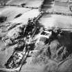
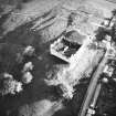
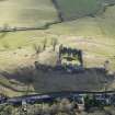
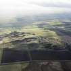
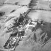
The modern hamlet of Hume occupies a rocky ridge overlooking the Merse and the English border to the south. A church and village are recorded at Hume from the mid-12th century, but direct reference to the castle does not appear until the later Middle Ages. This site is remarkable for its 18th century folly and the juxtaposition of castle and village: and not just any village but the largest deserted village in south-east Scotland. While today’s village comprises a row of twenty 19th century and modern houses along the north side of the public road through the village, in the late 17th century there were 86 houses in the village according to the Hearth tax returns.
The Hume and Greenlaw estate was granted to a son of the Earl of Dunbar in the early 13th century whose family name, Home, became eponymous with the name of the land they had acquired and was a well-known surname in the eastern borders. It is possibly from that time that a castle was built on the outcrop of rock now crowned by the fantastical castellated folly erected by the Earl of Marchmont in the late 18th century. The village was devastated in the 14th century during the Wars of Independence and cleared in the late 18th century, while the castle, fought over in the 16th and 17th centuries, was finally destroyed by Cromwell’s army in 1650.
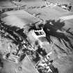
The size of the settlement was revealed in a survey by Piers Dixon and a local team of young people in 1987. The sites of many houses and ridge and furrow cultivation was mapped that stretched from modern village for half a mile to the west on either side of the loaning that leads to the churchyard of the former parish church of St Nicholas. The church itself has been robbed of stone and can only be traced as a platform surrounded by gravestones. The village houses that were located did not stand to any great height and the walls were mostly reduced to footings or robber trenches, suggesting that the superstructure of the walls may have been of perishable material, such as clay, on a stone base.
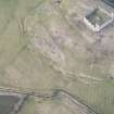
The 1987 survey lay dormant in the local records for almost 30 years until the Hume Castle Preservation Trust acquired the site. Royal Commission on the Ancient and Historical Monuments of Scotland answered a request for help from them to interpret the site that led to a resurvey of the castle and surrounding field using a low level aerial survey by UAV in 2015 (including a video). A 3D model of the ground surface was produced from which a plan of the castle and surrounding part of the village was mapped. Within the field in which the castle stood some 25 houses and yards alone were located forming rows of properties along the hollow ways of the village streets to north and south of the castle rock. However, this is only about one third of the late 17th century village, the rest of which still lies, further to the west. On the slopes to the south of the village, two phases of ridge and furrow were revealed, with straight narrow, Improvement period ridges over curving broad ridges of medieval origin, hitherto unnoticed.
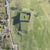
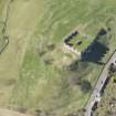
The castle
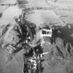
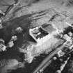
The 3D model also showed that there was a rampart on the east end of the castle rock outside the stone walls of the folly suggesting there might have been an earthwork and timber castle here, possibly dating to the 13th century. There was also an outwork of the castle on the west which can be traced from the stone footings around the squared shape of the outcrop at this end. Further indications of the early castle were shown clearly by the 3D survey to include an earlier wall outside the present west wall which included a round tower immediately in front of the present entrance and another round tower on an outcrop outside the north wall which had been invisible until the UAV survey. This evidence suggested an enclosure castle replaced the earlier earthwork in the 13th or 14th centuries, which was in turn replaced by a large tower and artillery defences in the 15th and 16th centuries, when the Homes acquired baronial status. Part of the tower still stands as a ruin inside the folly, a 15th century dumbbell gun-loop is built into the west wall and the sloping artillery defence of the south wall is of late 16th or 17th century date. The outer approach to the castle was via a ramp from the west between two robbed-out buildings, with a large terraced garden on the south, which gives a more pleasurable aspect to the castle than hitherto appreciated.
Dr Piers Dixon, Deputy Head of Survey and Recording, HES
Watching Brief (19 November 2018 - 22 November 2018)
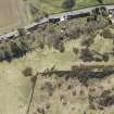
NT 70502 41492 A watching brief was carried out, 19-22 November 2018, during drainage works along the road through Hume.
The watching brief revealed the remains of a crude stone surface across the entirety of the trench area representing a possible trackway or ancient road related to the castle and surrounding area. Material related to both 19th and 20th century activity were also observed.
No other significant archaeological remains or small finds were discovered.
Archive: NHRE (intended)
Funder: Scottish Borders Council
Katie Walker - AOC Archaeology Group
(Source: DES Vol 20)
Sbc Note
Visibility: This is an upstanding earthwork or monument.
Information from Scottish Borders Council

