Following the launch of trove.scot in February 2025 we are now planning the retiral of some of our webservices. Canmore will be switched off on 24th June 2025. Information about the closure can be found on the HES website: Retiral of HES web services | Historic Environment Scotland
Crosshall, Eccles Cross
Cross (Medieval)
Site Name Crosshall, Eccles Cross
Classification Cross (Medieval)
Alternative Name(s) Carved Stone; Crosshall Farm; Deadriggs
Canmore ID 58543
Site Number NT74SE 5
NGR NT 7606 4223
Datum OSGB36 - NGR
Permalink http://canmore.org.uk/site/58543
- Council Scottish Borders, The
- Parish Eccles
- Former Region Borders
- Former District Berwickshire
- Former County Berwickshire
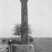
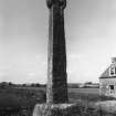
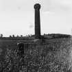
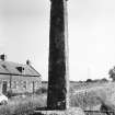
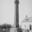
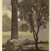
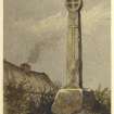
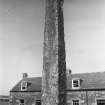
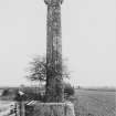
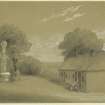
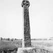
Crosshall cross is situated by the side of the road approximately 300m south-west of Crosshall farmhouse. It probably dates from the twelfth century, and is thought to be a memorial stone erected to mark the grave of an important person.
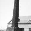
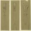
The cross is just under 3m high, and is inserted into a large block of stone that is itself over 1m in height. The shaft tapers towards the top, terminating in a disc on which a cross is carved on either side. Each side of the shaft bears carved decoration; a naked man and greyhound on the east side, and a coat of arms on the west, south and possibly the north side. On the west and north sides, there are also depictions of a carved cross. A sword is depicted on the south side.
The symbols carved on this cross suggest that the person whom it commemorates may have been to the Crusades and the coat of arms may represent the Soulis family. In the nineteenth century, local tradition recorded that it commemorated a governor of the nearby Hume Castle who had been killed in a skirmish.
Text prepared by RCAHMS as part of the Accessing Scotland's Past project
NT74SE 5 7606 4223.
(NT 7606 4223) Cross (NR)
OS 6" map, Berwickshire, 2nd ed., (1909).
A tall, wheel-headed cross, 14ft 10ins high. The shaft, oblong in section, has a slight taper upwards to the head, which is 1ft 10ins in diameter. It stands on a built stone base with a central socket stone. A plain cross is cut in relief on both sides of the head; on the E face of the shaft is carved the figure of a man and a dog, on the W face, a latin cross beneath a shield, on the S, a similar shield above a sword, and on the N, a latin cross placed on a calvary (RCAHMS 1915). It was possibly erected after the second crusade (1114); local tradition says that a governor of Hume Castle was killed here in a skirmish (New Statistical Account (NSA, R D Thomson) 1845).
The repetition of many crosses, with shields bearing arms, shows that the monument relates to one who had been at the holy war. The first time any number of Scots went to these was to the second crusade (J Hardy 1885).
R Robertson 1792.
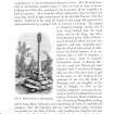
This cross, as described by the previous authorities, is in good condition (see RCAHMS 1915, fig.77).
Visited by OS(JD) 28 January 1955.
No change to the previous field report.
Visited by OS(RD) 20 July 1966.
A medieval, disc-headed cross, standing by the roadside about 300m SW of Crosshall farm.
RCAHMS 1980, visited 1979.
Field Visit (23 October 1908)
143. Cross, Crosshall.
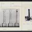
Situated about ¼ mile south-west of Crosshall farm, at the roadside and opposite to a row of farm cottages, stands a tall wheel-headed cross (fig. 77 [SC 1173038]). It is a monolith inserted into a built stone base with a central socket stone, the whole rising to a height of 14 feet 10 inches above the ground level. The shaft, which is a rectangular oblong in section, has a slight taper upwards towards the circular head which measures 1 foot 10 inches in diameter. On both sides of the head a plain equal-armed cross is cut in low relief within a marginal border. The main axis of the cross-shaft faces north and south and is carved on all four sides. On the east the figure of a man is rudely incised with his arms folded on his breast and his feet turned inwards: beneath him, placed vertically, a hound: on the west a Latin cross with the ends of the arms pointed and above it a shield bearing arms. On the south a similar shield above a sword, the quillons of which are slightly depressed: on the north a Latin cross placed on a calvary.
See Ber. Nat. Club, 1882-84, p. 366; New Stat. Acct. (Ber.), p. 56.
RCAHMS 1915, visited 23rd October 1908.
OS Map: Ber., xxviii. NW.
Publication Account (1985)
The 3m sandstone shaft is set in a huge square stone base. Rectangular in section, it tapers slightly upwards and is carved on all four sides. The east face bears a roughly-incised figure of a man, his anns folded and feet turned inwards; and beneath him, a hound. The west side, by contrast, has a Latin cross with pointed ends to its anns, sunnounted by shield. A similar shield, set above a sword, features on the south face; and a Latin cross placed on a calvary on the north face. On both sides of the circular 'wheel' head a plain, equal-anned cross has been cut, edged around with a marginal border.
The place where the cross stands was fonnerly called Deadriggs, traditionally the site of a "bloody battle.
Information from 'Exploring Scotland's Heritage: Lothian and Borders', (1985).
Sbc Note (15 April 2016)
Visibility: Standing structure or monument.
Information from Scottish Borders Council


