|
Prints and Drawings |
SUD 68/1 |
Records of the Royal Commission on the Ancient and Historical Monuments of Scotland (RCAHMS), Edinbu |
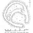
Publication drawing; plan of 'Hut Circle, Tannachy'. |
c. 1909 |
Item Level |
|
|
Prints and Drawings |
SUD 68/2 |
Records of the Royal Commission on the Ancient and Historical Monuments of Scotland (RCAHMS), Edinbu |
Alternative version of SUD 68/1 |
c. 1909 |
Item Level |
|
|
Photographs and Off-line Digital Images |
C 46891 CN |
RCAHMS Aerial Photography |
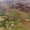
Grudie, Breton Rock, oblique aerial view, taken from the SE, centred on a township. Hut-circles and a field-system are visible in the bottom right-hand corner of the photograph. |
23/6/1995 |
Item Level |
|
 |
On-line Digital Images |
SC 1665129 |
Records of the Royal Commission on the Ancient and Historical Monuments of Scotland (RCAHMS), Edinbu |
Publication drawing; plan of 'Hut Circle, Tannachy'. |
c. 1909 |
Item Level |
|
 |
On-line Digital Images |
SC 1693022 |
RCAHMS Aerial Photography |
Grudie, Breton Rock, oblique aerial view, taken from the SE, centred on a township. Hut-circles and a field-system are visible in the bottom right-hand corner of the photograph. |
23/6/1995 |
Item Level |
|
 |
On-line Digital Images |
SC 2348413 |
Records of the Ordnance Survey, Southampton, Hampshire, England |
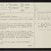
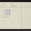
Tannachy, NC70NE 8, Ordnance Survey index card, page number 1, Recto |
1958 |
Item Level |
|
 |
On-line Digital Images |
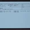
SC 2348414 |
Records of the Ordnance Survey, Southampton, Hampshire, England |
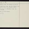
Tannachy, NC70NE 8, Ordnance Survey index card, page number 2, Verso |
1958 |
Item Level |
|
 |
On-line Digital Images |
SC 2348415 |
Records of the Ordnance Survey, Southampton, Hampshire, England |
Tannachy, NC70NE 8, Ordnance Survey index card, Recto |
1958 |
Item Level |
|
 |
On-line Digital Images |
SC 2348416 |
Records of the Ordnance Survey, Southampton, Hampshire, England |
Tannachy, NC70NE 8, Ordnance Survey index card, Recto |
1958 |
Item Level |
|
|
All Other |
551 166/1/1 |
Records of the Ordnance Survey, Southampton, Hampshire, England |
Archaeological site card index ('495' cards) |
1947 |
Sub-Group Level |
|


