
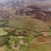
Tannachy


Field System (Period Unassigned), Hut Circle(S) (Prehistoric)
Site Name Tannachy
Classification Field System (Period Unassigned), Hut Circle(S) (Prehistoric)
Canmore ID 5843
Site Number NC70NE 8
NGR NC 756 077
NGR Description Centred ND 756 077
Datum OSGB36 - NGR
Permalink http://canmore.org.uk/site/5843


- Council Highland
- Parish Rogart
- Former Region Highland
- Former District Sutherland
- Former County Sutherland
NC70NE 8 centred 756 077
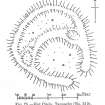
(NC 756 077) Settlement and Field System (NR) (5 huts shown)
OS 1:10,000 map, (1970).
A settlement of five huts ('A'-'E') within a relatively large field system of numerous heaps, ruinous field walls and occasional lynchets. All dimensions are between wall centres.
'A' (RCAHMS 1911) is 15.5m SE-NW by 13.5m. The curving inner wall forms an enclosure measuring 11.0m NW-SE. The chamber illustrated in the W arc is extant, but because of heavy peat growth, it is uncertain whether it is contemporary with the hut. The other chambers were not traced.
'B' (RCAHMS 1911) is a small circular enclosure 5.0m in diameter.
'C' is 10.5 SW-NE by 10.0m. The entrance is in the SW.
'D' measures 13.0m E-W by 10.5m. The wall, spread to 2.5m in the W, expands to 3.5m at the entrance in the E.
E (RCAHMS 1911) is 12.5 ESE-WNW by 10.0m. The entrance is in the ESE.
Revised at 1:10,000.
Visited by OS (WDJ) 19 April 1964 and (JB) 18 August 1975.
RCAHMS 1911, visited 1909.

