|
Manuscripts |
MS 725/138 |
Historic Scotland Archive Project |
Report of coastal assessment survey for Historic Scotland: The Firth of Forth from Dunbar to the border of Fife. (3 volumes)
Revised version with amended text. |
1996 |
Item Level |
|
|
Manuscripts |
MS 2221/05 |
Historic Scotland Archive Project |
Survey archive: List of Vertical Aerial Photographs consulted in the NMRS, from Coastal Assessment Survey, 'The Firth of Forth from Dunbar to the Coast of Fife'. |
1996 |
Item Level |
|
 |
On-line Digital Images |
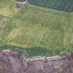
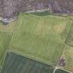
DP 215295 |
RCAHMS Aerial Photography Digital |
Oblique aerial view of the cropmarks of the enclosure and the site of Seacliff Tower, looking WSW. |
18/6/2015 |
Item Level |
|
 |
On-line Digital Images |
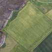
DP 215296 |
RCAHMS Aerial Photography Digital |
Oblique aerial view of the cropmarks of the enclosure and the site of Seacliff Tower, looking ESE. |
18/6/2015 |
Item Level |
|
 |
On-line Digital Images |
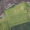
DP 215297 |
RCAHMS Aerial Photography Digital |
Oblique aerial view of the cropmarks of the enclosure and the site of Seacliff Tower, looking E. |
18/6/2015 |
Item Level |
|
 |
On-line Digital Images |
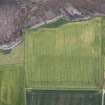
DP 215298 |
RCAHMS Aerial Photography Digital |
Oblique aerial view of the cropmarks of the enclosure and the site of Seacliff Tower, looking ENE. |
18/6/2015 |
Item Level |
|
 |
On-line Digital Images |
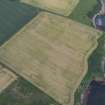
DP 215299 |
RCAHMS Aerial Photography Digital |
Oblique aerial view of the cropmarks of the enclosure and the site of Seacliff Tower, looking NE. |
18/6/2015 |
Item Level |
|
 |
On-line Digital Images |
DP 215300 |
RCAHMS Aerial Photography Digital |
Oblique aerial view of the cropmarks of the enclosure and the site of Seacliff Tower, looking NE. |
18/6/2015 |
Item Level |
|
 |
On-line Digital Images |
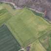
DP 216722 |
RCAHMS Aerial Photography Digital |
Oblique aerial view of the cropmarks of the enclosure and the site of Seacliff Tower, looking NW. |
9/7/2015 |
Item Level |
|
 |
On-line Digital Images |
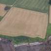
DP 217576 |
RCAHMS Aerial Photography Digital |
Oblique aerial view of the cropmarks of the enclosure and the site of Seacliff Tower, looking WSW. |
22/7/2015 |
Item Level |
|
 |
On-line Digital Images |
SC 2453695 |
Records of the Ordnance Survey, Southampton, Hampshire, England |
Seacliff Tower, NT68SW 5, Ordnance Survey index card, Recto |
1958 |
Item Level |
|
 |
On-line Digital Images |
SC 2453696 |
Records of the Ordnance Survey, Southampton, Hampshire, England |
Seacliff Tower, NT68SW 5, Ordnance Survey index card, page number 1, Recto |
1958 |
Item Level |
|
 |
On-line Digital Images |
SC 2453697 |
Records of the Ordnance Survey, Southampton, Hampshire, England |
Seacliff Tower, NT68SW 5, Ordnance Survey index card, page number 2, Verso |
1958 |
Item Level |
|
|
Manuscripts |
MS 2221/01 |
Historic Scotland Archive Project |
Survey archive: Photographic register from Coastal Assessment Survey, 'The Firth of Forth from Dunbar to the Coast of Fife'. |
1996 |
Batch Level |
|
|
Photographs and Off-line Digital Images |
BP 55/02 CN |
Historic Scotland Archive Project |
Survey photographs: Possible enclosure and World War II defences at Whitberry point; general view of Bathan's Strand; Ravensheugh Sands showing World War II defences anti-tank blocks, pill-box, look-out, gateway blocks E and W, possible rubble wall/causeway; sea wall at Scougal Rocks; Seacliff Tower including views of N and W walls; Seacliff Harbour; Auldhame 16th century house; North Berwick including Castle Hill motte, Sands Cottage 3 Melbourne Road, paddling pool, information board at Victoria Road and Quality Street, St Andrew's Kirk and graveyard with 13th century cope gravestone and 13th and 15th century gravestones. |
1996 |
Batch Level |
|
|
All Other |
BP 55/05 CN |
Historic Scotland Archive Project |
Survey photographs: Multiple views of Tantallon Castle and associated features to seaward; salt pans at Cockenzie and two views of the power station; boundary/sea wall at Prestonpans and the parish kirk and features of Cuthil house; aspects of Morrison's haven and the harbour at Fisherrow. |
1996 |
Batch Level |
|
|
Photographs and Off-line Digital Images |
BS 47/02 CS |
Historic Scotland Archive Project |
Survey photographs: Possible enclosure and World War II defences at Whitberry point; general view of Bathan's Strand; Ravensheugh Sands showing World War II defences anti-tank blocks, pill-box, look-out, gateway blocks E and W, possible rubble wall/causeway; sea wall at Scougal Rocks; Seacliff Tower including views of N and W walls; Seacliff Harbour; Auldhame 16th century house; North Berwick including Castle Hill motte, Sands Cottage 3 Melbourne Road, swimming pool and paddling pool; information board at Victoria Road and Quality Street, St Andrew's Kirk and graveyard with 13th century cope gravestone and 13th and 15th century gravestones. |
1996 |
Batch Level |
|
|
Manuscripts |
MS 2221/02 |
Historic Scotland Archive Project |
Survey archive: Record sheets from Coastal Assessment Survey, 'The Firth of Forth from Dunbar to the Coast of Fife'. |
1996 |
Batch Level |
|
|
Manuscripts |
MS 2221/03 |
Historic Scotland Archive Project |
Survey archive: Record sheets and maps of Erosion Units, from Coastal Assessment Survey, 'The Firth of Forth from Dunbar to the Coast of Fife'. |
1996 |
Batch Level |
|
|
Manuscripts |
MS 2221/04 |
Historic Scotland Archive Project |
Survey archive: Record sheets and maps of Geology and Coastal Geomorphology Units , from Coastal Assessment Survey, 'The Firth of Forth from Dunbar to the Coast of Fife'. |
1996 |
Batch Level |
|
|
All Other |
551 166/1/1 |
Records of the Ordnance Survey, Southampton, Hampshire, England |
Archaeological site card index ('495' cards) |
1947 |
Sub-Group Level |
|


