
Pricing Change
New pricing for orders of material from this site will come into place shortly. Charges for supply of digital images, digitisation on demand, prints and licensing will be altered.
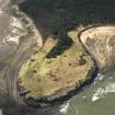
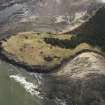
St Baldred's Cradle


Cairn (Prehistoric)
Site Name St Baldred's Cradle
Classification Cairn (Prehistoric)
Canmore ID 57867
Site Number NT68SW 4
NGR NT 6371 8125
Datum OSGB36 - NGR
Permalink http://canmore.org.uk/site/57867


- Council East Lothian
- Parish Whitekirk And Tyninghame
- Former Region Lothian
- Former District East Lothian
- Former County East Lothian
NT68SW 4.00 6371 8125
NT68SW 4.01 637 812 Pillbox (possible)
(NT 6371 8125) Cairn (NR)
OS 6" map (1969)
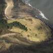
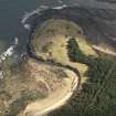
Cairn, St Baldred's Cradle: This fine round cairn of stones covered with grass is situated on a promontory, about 40ft OD and some 120 yards W of the rock known as St Baldred's Cradle. It is 60ft in diameter and 11ft high.
RCAHMS 1924, visited 1913
This cairn consists of a stony mound now covered with sand and grass; it is oval in shape rather than circular and measures 28m from E to W by 25m transveresly and has an an average height of 3.0m. The top of the cairn is flattish and measures 13m from E to W by 12m transversely. There is no evidence of a cist or kerb.
Revised at 1:2500.
Visited by OS (WDJ) 14 November 1962
This cairn was demolished early in the last war, and the mound now visible covers only the remains of a concrete pill-box.
H C Nisbet 1975.
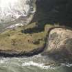
This is an oval cairn 3-4m in height, grass covered and with a flat top. The only visible remains of the WW2 pill-box, which was sited on the top of the cairn, are two loose stones. The cairn seems to be stabilised by the course dune grass covering it, traces of the pill box may remain underground. Several footpaths criss-cross the mound but are causing minimal damage. The pillbox as observed on 1946 AP's, was of the classic type 22 hexagonal shape. The pillbox had either been sunken deep into the ground, or material had been piled up around it to roof level, and an attempt was made to disguise the roof with a covering of turf.. It is therefore possible that the pillbox is now totally buried in situ and that the centre of the cairn was destroyed during its construction. B108 7196-7 15/4/46.
Site recorded by GUARD during the Coastal Assessment Survey for Historic Scotland, 'The Firth of Forth from Dunbar to the Coast of Fife' 17th February 1996.
A visit to the site in November 2001 confirms that this cairn survives and is as the Ordnance Survey description of 1962. The cairn still stands to a height of over 3m.
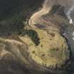
There is no evidence of a pillbox that has possibly demolished this site, but 150m to the SW is an area of disturbed ground which are the remains of a Second World War trench system. Mr Nisbet may have mistaken these for the location of the cairn in 1975.
Information from D Easton, November 2001
Field Visit (21 June 1913)
Cairn, St. Baldred’s Cradle, Tynemouth.
On a promontory, which rises about 40 feet above high water mark, some 700 yards north-west of the mouth of the River Tyne and about 120 yards west of the rock known as St. Baldred's Cradle, is a fine circular cairn of stones, covered with a growth of grass, 60 feet in diameter and rising to a height of 11 feet above the surrounding level.
RCAHMS 1924, visited 21 June 1913
OS Map ref: vi. N.E.
Field Visit (14 November 1962)
This cairn consists of a stony mound now covered with sand and grass; it is oval in shape rather than circular and measures 28m from E to W by 25m transveresly and has an an average height of 3.0m. The top of the cairn is flattish and measures 13m from E to W by 12m transversely. There is no evidence of a cist or kerb.
Revised at 1:2500.
Visited by OS (WDJ) 14 November 1962
Field Visit (1975)
This cairn was demolished early in the last war, and the mound now visible covers only the remains of a concrete pill-box.
H C Nisbet 1975.
Field Visit (17 February 1996)
This is an oval cairn 3-4m in height, grass covered and with a flat top. The only visible remains of the WW2 pill-box, which was sited on the top of the cairn, are two loose stones. The cairn seems to be stabilised by the course dune grass covering it, traces of the pill box may remain underground. Several footpaths criss-cross the mound but are causing minimal damage. The pillbox as observed on 1946 AP's, was of the classic type 22 hexagonal shape. The pillbox had either been sunken deep into the ground, or material had been piled up around it to roof level, and an attempt was made to disguise the roof with a covering of turf.. It is therefore possible that the pillbox is now totally buried in situ and that the centre of the cairn was destroyed during its construction. B108 7196-7 15/4/46.
Site recorded by GUARD during the Coastal Assessment Survey for Historic Scotland, 'The Firth of Forth from Dunbar to the Coast of Fife' 17th February 1996.
Field Visit (November 2001)
A visit to the site in November 2001 confirms that this cairn survives and is as the Ordnance Survey description of 1962. The cairn still stands to a height of over 3m.
There is no evidence of a pillbox that has possibly demolished this site, but 150m to the SW is an area of disturbed ground which are the remains of a Second World War trench system. Mr Nisbet may have mistaken these for the location of the cairn in 1975.
Information from D Easton, November 2001
Archaeological Evaluation (29 August 2015 - 23 April 2016)
NT 6371 8125 (NT68SW4) A programme of fieldwork incorporating a topographic survey, a geophysical survey and a trial excavation was undertaken, 29 August 2015 – 23 April 2016.
The topographic survey generated an accurate plan of the monument, which significantly increased understanding of the layout and location of the site. The geophysical survey provided evidence of surviving sub-surface features. The two trenches excavated contained no artefacts or datable material, but did demonstrate in situ survival of the cairn below the
WW2 and later alterations. The work also established that the WW2 pillbox construction and decommissioning works have substantially altered the original shape of the mound/cairn.
Archive: NRHE
David Connolly – Connolly Heritage Consultancy
(Source: DES, Volume 17)
Earth Resistance Survey (29 August 2015)
NT 63709 81255 Edinburgh Archaeological Field Society carried out a ground resistance survey of four 20 x 20m grids on the site of a recorded cairn and pillbox on a prominent mound at Whitberry Point on 29 August 2015. Results showed a sub-circular higher resistance of c19 x 19m with a central U-shaped lower resistance feature. There were also rectangular and linear low resistances to the N and E. This could represent traces of the reported cairn and superimposed WW2 military structure, possibly a pillbox or observation post on the site, given the dimensions of the high resistance anomaly.
Archive: East Lothian SMR and National Record of the Historic Environment (NRHE)
Funder: Connolly Heritage Consultancy and Edinburgh Archaeological Field Society
Ian Hawkins and Donald Matthews – Edinburgh Archaeological Field Society
(Source: DES, Volume 16)
Archaeological Evaluation (29 August 2016 - 30 August 2016)
NT 6371 8125 An assessment was carried out, 29–30 August 2016, of the cairn known as St Baldred’s Cradle as part of a community participation programme. The work consisted of a topographic and geophysical survey, plus the excavation of two small evaluation trenches.
The cairn was said to have been destroyed by the insertion of a type 22 pillbox during WW2. However, D Easton (2001) suggested this was not the case. The trenches uncovered evidence of the brickwork for the emplacement; and more tellingly, the original cairn seems to be largely extant. Although it has been partially damaged by the 20th-century
defensive structure, it is definitely a mound of human creation and may represent a prehistoric site.
Archive: Connolly Heritage Consultancy
David Connolly – Connolly Heritage Consultancy
(Source: DES, Volume 17)

