|
Manuscripts |
MS 725/138 |
Historic Scotland Archive Project |
Report of coastal assessment survey for Historic Scotland: The Firth of Forth from Dunbar to the border of Fife. (3 volumes)
Revised version with amended text. |
1996 |
Item Level |
|
|
Manuscripts |
MS 2221/05 |
Historic Scotland Archive Project |
Survey archive: List of Vertical Aerial Photographs consulted in the NMRS, from Coastal Assessment Survey, 'The Firth of Forth from Dunbar to the Coast of Fife'. |
1996 |
Item Level |
|
 |
On-line Digital Images |
DP 058317 |
RCAHMS Aerial Photography Digital |
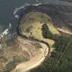
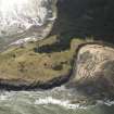
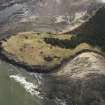
Oblique aerial view centred on the remains of the cairn with the WW II trench system adjacent, taken from the SW. |
4/2/2009 |
Item Level |
|
 |
On-line Digital Images |
DP 058318 |
RCAHMS Aerial Photography Digital |
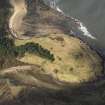
Oblique aerial view centred on the remains of the cairn with the WW II trench system adjacent, taken from the ENE. |
4/2/2009 |
Item Level |
|
 |
On-line Digital Images |
DP 058319 |
RCAHMS Aerial Photography Digital |
Oblique aerial view centred on the remains of the cairn with the WW II trench system adjacent, taken from the NE. |
4/2/2009 |
Item Level |
|
 |
On-line Digital Images |
DP 058320 |
RCAHMS Aerial Photography Digital |
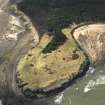
Oblique aerial view centred on the remains of the cairn at St Baldred's Cradle near Dunbar with the WW II trench system adjacent, taken from the N. |
4/2/2009 |
Item Level |
|
 |
On-line Digital Images |
DP 058321 |
RCAHMS Aerial Photography Digital |
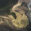
Oblique aerial view centred on the remains of the cairn with the WW II trench system adjacent, taken from the NW. |
4/2/2009 |
Item Level |
|
 |
On-line Digital Images |
DP 058322 |
RCAHMS Aerial Photography Digital |
Oblique aerial view centred on the remains of the cairn with the WW II trench system adjacent, taken from the WNW. |
4/2/2009 |
Item Level |
|
|
Manuscripts |
MS 36/52 |
Records of the Royal Commission on the Ancient and Historical Monuments of Scotland (RCAHMS), Edinbu |
Field notebook of James Graham Callander (RCAHMS). Title 'East Lothian No. 2'. |
17/6/1913 |
Item Level |
|
 |
On-line Digital Images |
SC 2453694 |
Records of the Ordnance Survey, Southampton, Hampshire, England |
St Baldred's Cradle, NT68SW 4, Ordnance Survey index card, page number 1, Recto |
c. 1958 |
Item Level |
|
|
Photographs and Off-line Digital Images |
BP 55/01 CN |
Historic Scotland Archive Project |
Survey photographs: Unclassified masonry structure; views of Dunbar including Old Harbour and Maltings/Warehouse, Victoria Harbour, Castle, Lamer Island Battery, Kirk Hill Braes long cist cemetery and site of urban excavation at leisure pool development; Belhaven Bay World War II defensive structures including look-outs, anti-tank blocks and a glider trap; anti-tank blocks at Hedderwick; St Baldred's Cradle cairn and Tyne Sands World War 2 pill box, fish trap and cart track marks.
Views of erosion at Dunbar and Belhaven Bay. |
1996 |
Batch Level |
|
|
Photographs and Off-line Digital Images |
BS 47/01 CS |
Historic Scotland Archive Project |
Survey photographs: Unclassified masonary structure; views of Dunbar including Old Harbour and Maltings/Warehouse, Victoria Harbour, Castle, Lamer Island Battery, Kirk Hill Braes long cist cemetery and site of urban excavation at leisure pool development; Belhaven Bay World War II defensive structures including look-outs, anti-tank blocks and a glider trap; anti-tank blocks at Hedderwick; St Baldred's Cradle cairn and Tyne Sands World War 2 pill box, fish trap and cart track marks.
Views of Belhaven Bay.
Coastal Unit at NT 683 788.
. |
1996 |
Batch Level |
|
|
Manuscripts |
MS 2221/02 |
Historic Scotland Archive Project |
Survey archive: Record sheets from Coastal Assessment Survey, 'The Firth of Forth from Dunbar to the Coast of Fife'. |
1996 |
Batch Level |
|
|
Manuscripts |
MS 2221/03 |
Historic Scotland Archive Project |
Survey archive: Record sheets and maps of Erosion Units, from Coastal Assessment Survey, 'The Firth of Forth from Dunbar to the Coast of Fife'. |
1996 |
Batch Level |
|
|
Manuscripts |
MS 2221/04 |
Historic Scotland Archive Project |
Survey archive: Record sheets and maps of Geology and Coastal Geomorphology Units , from Coastal Assessment Survey, 'The Firth of Forth from Dunbar to the Coast of Fife'. |
1996 |
Batch Level |
|
|
All Other |
551 166/1/1 |
Records of the Ordnance Survey, Southampton, Hampshire, England |
Archaeological site card index ('495' cards) |
1947 |
Sub-Group Level |
|


