
Pricing Change
New pricing for orders of material from this site will come into place shortly. Charges for supply of digital images, digitisation on demand, prints and licensing will be altered.
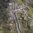
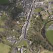
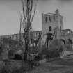
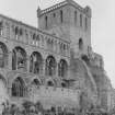
Jedburgh Abbey


Abbey (Medieval)
Site Name Jedburgh Abbey
Classification Abbey (Medieval)
Alternative Name(s) Jedburgh, Augustinian Abbey Of St Mary
Canmore ID 57020
Site Number NT62SE 15
NGR NT 65038 20448
Datum OSGB36 - NGR
Permalink http://canmore.org.uk/site/57020


First 100 images shown. See the Collections panel (below) for a link to all digital images.
- Council Scottish Borders, The
- Parish Jedburgh
- Former Region Borders
- Former District Roxburgh
- Former County Roxburghshire
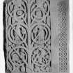
Jedburgh carved stones
Jedburgh’s twelfth-century abbey was built on the site of an earlier Anglo-Saxon church, probably part of a monastery, from which a number of carved stones survive. Most are fragments of larger monuments, and the collection represents a shrine chest (nos 1.1 and 1.2), five free-standing crosses (nos 5, 9, 10, 8/13, 11), an architectural panel (no 12) and three recumbent grave-covers. There is also a massive cross-base, found at the north-east end of the town and now in the grounds of Mary Queen of Scots House. Overall the collection dates from the later eighth century to the eleventh century, and its artistic links are with Northumbrian sculpture and with the Pictish traditions of Tayside.
A Ritchie 2019
NT62SE 15.00 65038 20448
NT62SE 15.01 NT 650 204 Roman altar
NT62SE 15.02 NT 650 204 Roman altar
NT62SE 15.03 NT 650 204 Grave-slab
NT62SE 15.04 NT c. 650 204 Screen fragment
(Centred NT 6503 2044) Jedburgh Abbey (NR) (In Ruins)
OS 25" map, (1921)
The site of the Augustinian Abbey of St. Mary has been occupied by a church from the 9th century onwards; but this early church only appears in history at the turn of the 11th and 12th centuries. This church seems to have been adopted by the Augustinians until their Abbey church was sufficiently advanced for use; no part of it has survivied, but the plan of the abbey cloister suggests that it stood in the position occupied by the six eastern bays of the present nave.
The house was founded by David I before 1139. The choir may be ascribed to the second quarter of the 12th century. The early church was probably demolished before 1174, and the church, as a whole, was evidently finished by the middle of the 13th century at the latest. That done, the cloister was remodelled.
The abbey was rendered uninhabitable by the English in 1297, and was thrice ravaged again in the 15th century. Reconstruction took place in the 14th and 15th centuries. The tower was partly rebuilt between 1504 and 1508, but in 1523 the abbey was burnt by the English, and again in 1555. However, the church was sufficiently entire to be used in 1552 for the consecration of Bishop David Painter. Seven years later the abbey was suppressed.
By 1220 an altar in the nave had been appropiated to parochial use, and a parish church is mentioned in the 16th century. In 1668-71 a new church was erected within the west end of the nave. In 1875 the parish church was removed to a new site, and the abbey church thereupon ceased to be a place of worship. At this time the ruin of the abbey was repaired and the post-Reformation additions removed. In 1913 the fabric was placed in the guardianship of the Ministry of Works and has since then been thoroughly consolidated.
RCAHMS 1956.
Finds of other Periods:
Immediately inside the entrance to the stair in the northern external buttress at the west portal of the Abbey Church, a Roman Altar has been re-used as a lintel. This altar may have come either from the fort at Cappuck (Roxb 20 NW 12) or, more probably, from some nearer site as yet unidentified.
In the south face of the south wall of the undercroft of the frater, there is set a fragment of Roman carved stone, 15 1/2 inches high x 13 1/2 inches wide. The piece seems to have been broken off from the left-hand top corner of the back of a large altar.
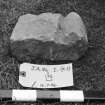
Part of the inscribed face of a Roman Altar, re-used in paving the NE angle of the presbytery after having been cut down to its present dimensions of 19 x 17 x 6 inches, now lies in the parish graveyard, adjoining the abbey on the north. Also in the parish graveyard there are three fragments of stone which, according to Mr C A R Radford who dates these fragments to about AD 700, doubtless came from the shrine of a saint - possibly St. Boisil, one of the early abbots of Old Melrose (Roxburgh 8 NE 7 ).
Also in the graveyard are fragments of more than one Dark Ages cross, and a small fragment of a cup and ring marked stone found within the Abbey in 1903.
RCAHMS 1956.
Antiquarian Observation (1857 - 1861)
Mason's marks from Scottish churches, abbeys and castles recorded between 1857 and 1861 on 29 drawings in the Society of Antiquaries of Scotland Collection.
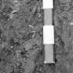
Excavation (1936 - 1937)
Field Visit (7 January 1963)
The Abbey and its associated buildings are as described and illustrated by RCAHMS 1956.
The fragment of Roman carved stone in the undercroft of the frater, and the fragments of Dark Age crosses in the graveyard were not located. The carved stone may lie with one of the many stone fragments on the floor of the small museum attached to the abbey.
Visited by OS(EGC) 7 January 1963.
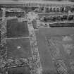
Aerial Photography (1968)
Oblique aerial photographs of Jedburgh Abbey and Jedburgh Castle Jail taken by John Dewar in 1968.
Excavation (1983)
Jedburgh Abbey Centred NT 6503 2044.
Component No.
Abbot's Hall (site) 3.1
Parlour (remains) 3.2
Day-stair (remains) 3.3
Chapter-house (remains) 3.4
? Treasury (remains) 3.5
? Warming-house (remains) and Reredorter (? site) 3.6
Frater (remains) 3.7
Kitchen (remains) 3.8
Infirmary (remains) 3.9
Meat-kitchen (remains) 3.10
Cloister (primary) (site) 3.11
Cloister (later) (remains) 3.12
Cellarium (remains) 1 3.13
Cellarium (remains) 2 3.14
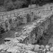
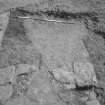
Several trial trenches were opened to the S of the Abbey precinct to help locate some of the monastic buildings that were to be fully uncovered in 1984. Part of an arch, including some finely tooled masonry, was found below the road (The Bow) to the S of the E range. Its position (formerly adjacent to the Jed Water) suggests it may have been part of the reredorter. At the junction of Abbey Close and The Bow a wall of about 3m height was exposed. Between the road and the Jed Water the construction of a lade that supplied the nearby 19th century silk works may have damaged some of the medieval structures that existed in that area. This work was carried out in conjunction with Kirkdale Archaeology.
Sponsor: SDD (AM)
J Lewis 1983a
Excavation (1984)
Following the partial excavation of 1936-37 and the trial trenching of 1983, during the summer of 1984 most of the abbey's claustral area was excavated, including: the cloister garth; East Range; West Range; frater; and extensive trenches beyond those ranges.
The East Range at the excavated level comprised: slype/parlour; chapter house of at least three phases with associated floor levels and burials; two apartments of unknown functions (although one may have included the foundations of the day stair); a quadripartite-vaulted undercroft of two bays EW and at least two bays NS, the northern two bays divided by a secondary partition wall; and possibly the reredorter beneath an extant 19th century house. The house straddled a stone-lined 19th century lade whose course may have echoed that of the monastic great drain.
Beyond the East Range were: the monastic graveyard; two phases of an exteded chapter house; wall foundations and associated metalled surface thought to be pre-Augustinian, and a ditch cutting through the early metalling. The ditch appartenly acted as a swer at some stage and was backflled in the 12th century presumably to allow the construction of the East Range. Further south, down an alluvial terrace, were the poorly-constructed walls of a building, or buildings, of uncertain date. To the SW and S of the frater were kitchens and other domestic apartments as well as at least two timber buildings of medieval age.
S of the frater were the substantial remains of a building descriebed by RCAHMS Roxburgh I (1956, 206) as the undercroft of the infirmary but which may have been the abbot's lodging. Beyond, the ground adjacent to the Jed Water had been made up in medieval times but had been consolidated with only limited success.
Several post-monastic dwellings were evident in the vicinity of the East Range and part of the 18th/19th century manse was located to the west of the cloister garth.
Sponsor: SDD (AM)
J H Lewis and G J Ewart 1984
Publication Account (1985)
Little more than the foundations survive of the monastic buildings which stood on the slope between the Abbey and the Jed Water, but the nave and the north transept are complete up to the topmost wallhead, and the tower stands as it was rebuilt in 1504-8.
The site had been occupied by a church since the 9th century; then, c1138, Augustinian Canons were brought from near Beauvais in France and by 1174 the choir, crossing and both transepts were sufficiently complete to be used for services. The nave was constructed by 1200 and by 1220 the east end was reconstructed after the removal of the original semicircular apse. The whole church was evidently complete by the mid 13th century when attentions were turned anew to the cloisters. These were remodelled, and by the late 15th century the north transept was extended.
It is a powerful place, very much dependent upon its clustered pillars and strong bridging arches. The great stone piers are carried, unusually, to the level of the triforium at first-storey level- a technique that creates an impression of height in an otherwise relatively low interior (of Dryburgh, no. 68). There, the delicate arcading is surmounted by a light and airy learstory.Remarkably intact in spite of constant warring, Jedburgh conveys the feelings of agreat abbey interior more fully than any other of the Border Abbeys.
After the reformation a church was 'made' within the crossing of the abbey and transepts; and a 'new' church was provided in the west part of the nave in 1671. In 1743 the crown arch and vault of the crossing collapsed and the dangers of falling masonry doubtless partly explain why the parish church was removed entirely from the abbey in 1875.
Within the museum there are a number of important sculptured stones, notably a Roman altar slab, sections of an 8th century AngJian shrine or sarcophagus elaborately decorated with birds, animals and vinescroll (see section 6), several pieces of 8th-9th century early Christian cross-heads and shafts, and a 12th century cross-inscribed tomb-cover-possibly that of John, Bishop of Glasgow who died in 1148 and was buried at Jedburgh.
Elsewhere in the town are the fine 16th century bastlehouse (Queen Mary's House) and hump-backed bridge across the Jed Water at the foot of the Canongate.
Information from 'Exploring Scotland's Heritage: Lothian and Borders', (1985).
Excavation (1990)
The three elements of the investigation in 1990 comprised: a watching brief duting cable-laying along the length of the nave and within the choir of the abbey church; trenching within the seventh bay of the nave, to establish whether there had been a temporary western gable during the building's early years; and excavation within the presbytery to determine whether the church had been extended eastwards at some stage. The cable trench yielded little of archaeological interest. Similarly, within a 5m by 2.2m trench in the nave, there were no structural remains, merely disturbed burials and recent artefacts within modern debris at least 0.7m deep. However, substantial masonry structures as well as several burials, some of them relatively undisturbed, were uncovered within an L-shaped trench in the presbytery.
A plinth of mortar-bonded masonry measuring 4.4m by 2.3m and separated from the presbytery walls by gaps of 1.4m and 0.7m, has been interpreted as the probable base of a high altar. E of the plinth, but distinct from it, were the 1.2m wide rubble foundations of a wall: although only partially exposed and damaged by a modern drain, this appears to be the primary E gable of the church. The wall was straight and not, as had been thought likely, apsidal. It is not clear, however, whether this gable wall was contemporary with or earlier than the adjacent plinth.
In the SW corner of the trench was a coffin comprising a lead box surrounded by timber planking. Attached to its exterior were some textile and thin beaten copper, the latter fashioned into shell-like patterns. Inside was a well-preserved, articulated skeleton with some hair still attached to the skull. Although its lid was missing, the coffin's construction and the skeleton's state of preservation suggest the burial to be of late 18th or 19th century date.
Immediately below this grave was a stone sarcophagus similar to many of those discovered during the excavation of the chapter house in 1984. This earlier coffin had been damaged and its skeleton disturbed, probably when the overlying grave was dug.
There were more graves, some disturbed and some in situ to the E of these burials. None has been excavated.
Sponsor: HBM
J Lewis 1990a.
Watching Brief (13 October 1999)
NT 650 203 The removal of gravel and underlying deposits was monitored in October 1999 in the S choir aisle in Jedburgh Abbey. The area was to be paved in order to facilitate wheelchair access. An additional hole was dug outside the SE corner of the S choir chapel in order to unblock a rainwater drain.
The earliest context encountered within the S choir comprised the sandstone foundations for the 12th-century pier forming the corner junction between the S choir aisle and the S transept. The interpretation of a stone feature at the base of the SE crossing pier was less clear. It does not appear substantial enough to be part of the pier foundations, although it might have been part of a hurried attempt to repair or prop up the base of the pier; the floor level appears to have sunk under the weight of the stonework. Another possible interpretation is that this is a remnant of a cross-wall keyed into the base of the pier, forming part of the E side of the first post-Reformation parish church.
No deposits of significance were disturbed in either of the areas excavated. The layers removed in the abbey church support the conclusion that there has been wholesale disruption of the floor levels within the building. The structural remnants at the base of the piers in the S choir aisle were left in situ and will be avoided when the new pavement is laid.
Sponsor: Historic Scotland
P Sharman 2000
Watching Brief (February 2005)
NT 6505 2045 A watching brief was undertaken in February 2005 during the removal of two bodies from the Victorian period burial plot of Nicholas Dodd to permit the reconstruction of the walled plot which had become derelict and at severe risk of collapse. The emptying of the plot permitted an examination of the graveyard deposits, as well as the complex repair and part rebuild of the N choir chapel E wall.
The burial plot was positioned within the E part of the graveyard in the angle formed by the E side of the demolished N choir chapel and the N wall of the presbytery. This area has been landscaped with imported earth, levelling up the old monastic ground surface by c 1.5-1.7m. Additionally, at some stage after the graveyard was created, the wall face of the abbey was cleared down to the original ground surface, creating an E-W trench, 1.8m across and 1.6m deep, running the length of the outer face of the presbytery N wall. This in turn has created a revetted bank holding up the graveyard main fill. It was into the W end of this revetted bank that the stone-lined burial plot was cut.
Archive to be deposited in NMRS.
Sponsor: HS.
D Stewart 2005
Watching Brief (14 May 2008)
NT 6503 2044 A watching brief was undertaken on 14 May 2008 during the excavation of a small trench at the E end of the Nave where there is a step down into the Crossing. The area appeared to have been disturbed during the laying of slabs in the 1990s. A lower deposit contained crushed sandstone, perhaps the remnants of an earlier floor surface. Human bone was also seen, although this appeared to have been redeposited in a mixed deposit containing relatively recent earthenware.
Archive: RCAHMS (intended)
Funder: Historic Scotland
Alan Radley (Kirkdale Archaeology), 2008
Watching Brief (12 April 2010)
NT 650 204 (centred on)
A watching brief was undertaken on 12 April 2010 during the excavation of four small holes for new signs. Three were located around the cloister, with the fourth towards the SW corner of the Abbey Church. At the three locations where existing signs were being replaced the excavations revealed disturbed ground. The fourth trench was dug in previously undisturbed ground in the NW corner of the cloister, just to the E of the W gravel path around the cloister. This trench contained topsoil overlying deposits that probably relate to recent landscaping. The trenches’
basal rubble rich deposit may represent immediate postreformation demolition or later clearance.
Archive: RCAHMS (intended)
Funder: Historic Scotland
D Murray 2010
OASIS Id: kirkdale1-279394
Test Pit Survey (2019)
NT 65037 20497 Excavation behind the rampart walls at Jedburgh Abbey have identified the structure and nature of the rampart wall, whilst also identifying an episode of infilling or dumping behind the rampart wall which, in places, contains re-deposited skeletal remains of both humans and animals and likely dates to the early 19th Century. It is unclear where these remains originated, however due to the proximity of the graveyard at the abbey, and the former lower churchyard and cattle market to the east, there is a high probability that the remains were disturbed and removed locally when the landscaping works were carried out. There is no evidence to suggest an earlier retaining wall for the ramparts set back from the current retaining wall, as had been postulated during the initial investigatory works. Prior to the infilling/dumping episode, the rampart wall may have acted more as a dry stone boundary wall, without retaining as much material behind it as there currently is. The wall was either rebuilt entirely, or modified to its current guise with a dry stone rear section and mortar bonded front face in the early 19th Century, creating a more formalised retaining wall. No in situ archaeological features were identified during the excavation works, with the deposits identified being indicative of a 19th century landscaping event.
Archive: NRHE (intended)
Funder: Scottish Borders Council
Ian Hill, Kieran Manchip and Michelle Gamble - Heritage Archaeological Research Practice
(Source: DES Vol 20)
Excavation (March 2020 - December 2020)
NT 65037 20497 Archaeological monitoring was required during repair works to Jedburgh Abbey Ramparts, from March -December 2020. Standing building recording was carried out on the rampart wall prior to repair/removal.
The works have identified the construction process for the ramparts along with uncovering the remains of five intact human burials in deposits identified below the rampart construction deposits. Earlier test-pitting works indicated that there was no physical evidence for an earlier retaining wall for the ramparts. The soil profile behind the rampart wall, and nature of construction of the wall suggest that prior to rampart construction the existing landscape sloped away to the S and E, both away from the abbey and the courthouse, with accumulations of hill wash and slope wash forming the soils for what would have originally formed part of the abbey graveyard. Excavation also revealed the remains of a small dry stone wall, which likely acted as a terrace (or boundary) wall to help reduce soil erosion behind it, or to create bounded areas within the former graveyard, and it is possible that further walls of this nature existed on the site prior to the construction of the ramparts. The construction of the ramparts has been found to have cut through these existing soil profiles and disturbed at least four intact graves (the likelihood is that a far greater number of graves were disturbed during the rampart construction), with the disturbed remains discarded at the time of construction. This is corroborated by the large proportion of disarticulated remains of both humans and animals found within the dumped material to raise the ground level during rampart construction, which were likely disturbed and displaced from land to the E of the ramparts (former lower churchyard, and later cattle market).
A double burial (Individuals A and B), containing an adult male and an adult female, in supine positions with hands at or under the hips, on a E/W orientation, was uncovered and excavated with samples taken for palaeoparasitology, aDNA, isotope analyses and radiocarbon dating. Radiocarbon dating reveals that these articulated human remains date to the 15th century, with a further partial burial dating to the 16th century (Individual E – was still within the unexcavated section).
The burials on-site seem to have undergone repeated disturbance during the active use of the graveyard. The construction of the rampart walls appears to have consisted of a foundation cut filled with large, mortar-bonded, rounded boulders and cobbles. The cut was through the existing soil profiles to provide a solid backing edge for the lower parts of the backing wall material, whilst the upper courses of the backing wall was built up against the E facing slope of the dumped material used to raise the ground level of the ramparts. In parts, this backing wall and rubble material was sporadically bonded with a sand or gravel-based mortar, likely in locations where the backing wall material was at risk of collapse or instability. This dry stone backing wall material was then subsequently faced by a mortar bonded, sandstone wall constructed from cut, but undressed sandstone block work.
The rampart wall was constructed during one phase. The presence
of a two pence coin dating to the latter part of Charles I’s reign (1642–1650) in the dumped material used to construct the ramparts in Section 6, indicates that the ramparts were not constructed before this date, putting an earliest date of construction of the ramparts at 1642, and a latest date of construction of the ramparts at 1775. The ramparts were altered over time with both sets of access stairs mapped by the mid-19th century, a single set of steps appears to have been either a later addition following initial rampart construction, or subsequently modified and repaired at a later date. Archive: NRHE
Funder: Scottish Borders Council
Ian Hill and Michelle Gamble – Heritage and Archaeological Research Practice (HARP)
(Source: DES Vol 22)
Note
INTERNAL REFERENCE:
Architect: Reginald Fairlie - Memorial to Marquis of Lothian
External Reference
EXTERNAL REFERENCE:
The National Library of Scotland, Edinburgh, contains, in a volume
of Sketches by Edward Duncan, Reference "MS. 3245.", a Sketch or
impression of Jedburgh Abbey. The chief attraction of Jedburgh is its
ruined Abbey, an 'ancient Monument'. It was founded by David I as a
Priory about1118, and raised thirty years later to the dignity of an
Abbey. The sketch is dated 1863.
The National LIbrary of Scotland, Edinburgh, contains, among the
'Uncatalogued MSS of General Hutton'. and numbered 151, 152, and 153,
Vol.1, an Engraving printed and sold by Jameson, Parliament Square, with
A Rutherford, Delt and Sculpt, 1776; Two smaller Engravings, sold
by J. Ainslie, Edinburgh; and Two Sketches of Jedburgh Abbey Church.
Courtauld Institute:
Jedburgh Abbey- G.F. Watts- Tomb of Lord Lothian- 829/4711

