
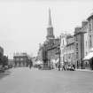
Haddington, Court Street, Town House


Town Hall (18th Century)
Site Name Haddington, Court Street, Town House
Classification Town Hall (18th Century)
Alternative Name(s) Town Hall
Canmore ID 56578
Site Number NT57SW 83
NGR NT 51476 73895
Datum OSGB36 - NGR
Permalink http://canmore.org.uk/site/56578


- Council East Lothian
- Parish Haddington
- Former Region Lothian
- Former District East Lothian
- Former County East Lothian
INFORMATION TAKEN FROM THE ARCHITECTURE CATALOGUE:
ARCHITECT: William Adam
James Gillespie Graham, 1830-31 (Additions and Spire)
Publication Account (1978)
An early reference to the Tolbooth occurs in 1425 (HTC Records, n. d., i, 19). References to its repair include a 1571 notice of 'the drawbrig of the tolbuith to be reparit, biggit and mendit in all necassaris with all diligens' (HTC Records, n. d., ii, 143). Reference to the drawbridge of the Tolbooth occurs again in 1658 (HTC Records, n .d., v, 39). In 1682 because of the large number of prisoners escaping from the structure the Town Council thought fit to hire 'some young, able, qualified and substantial man' as jailer (HTC Records, n. d., vi, 3). By 1732 the Tolbooth was ruinous and the Town Council meetings were transferred to the towns' library, while the steeple, town clock and great bell were taken down for safety (HTC Records, n.d,, vi, 247) . A newTown House was begun in 1748. The building had accommodation for the sheriff court and Town Council while the ground floor held prisoners. The Assembly Rooms were added to the Town House in 1788 and were built on pillars so that a market for grain could be held beneath. This market was ultimately abandoned (Gray, 1944, 140). The steeple dates from the early 1830s and the whole building underwent renovation in 1956.
Information from ‘Historic Haddington: The Archaeological Implications of Development’ (1978).

