
Kelphope Burn


Fort (Prehistoric), Settlement (Prehistoric)
Site Name Kelphope Burn
Classification Fort (Prehistoric), Settlement (Prehistoric)
Canmore ID 55967
Site Number NT55NW 10
NGR NT 5211 5639
Datum OSGB36 - NGR
Permalink http://canmore.org.uk/site/55967


- Council Scottish Borders, The
- Parish Lauder
- Former Region Borders
- Former District Ettrick And Lauderdale
- Former County Berwickshire
NT55NW 10 5211 5639.
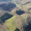
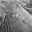
A fort is situated at about 1000ft OD, on top of a steep-sided spur which projects into the Glen on the E side of the Kelphope Burn, above Hazeldean Wood. It appears to have been circular or oval, about 223ft in internal diameter, but the outline is indefinite. Towards the E end of the spur is a well-defined rampart, 6ft high externally, with a ditch 36 ft across behind it. The low, indefinite remains of a second, external, rampart may also be seen. Low mounds are visible on the N and S flanks.
RCAHMS 1915, visited 1908
NT 5203 5633. The only existing remains are the ramparts on the E; the inner rampart is 2.5m high, the outer 0.7m high. On the N,S and W there are vague traces of the outline of the fort, showing as a slight swelling. On the N and S, the bank, spread to a width of 12.0m, appears to join with the natural slopes. The interior is very broken, possibly due to quarrying.
Visited by OS (JD) 12 May 1955
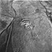
NT 5211 5639. This feature is as described, except that there are indications that a rampart may have enclosed the whole hill-top giving an overall area of about 154m NNE-SSW by 38m. Traces of a rampart can be seen as a scarp on th N side of the hill, and inter- mittently on the S side. the highest part of the hill to the E seems to have been enclosed by the now reduced innermost rampart, perhaps representing a later phase of occupation. It is within this area that about 8 timber house platforms can be seen. Although severely mutilated, the situation - set back from the steep western slopes - would suggest that this was a settlement perhaps superceding an earlier fort or settlement (c/f NT55NW 4). The entrance may have been in the NE where a later field bank crosses the defences.
Surveyed at 1:10 000.
Visited by OS (BS) 4 May 1979
Field Visit (16 October 1908)
225. Fort, Kelphope Burn.
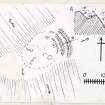
Situated on the top of a spur which projects into the Glen on the east side of the Kelphope Burn, directly above the Hazeldean Wood and about 1 ½ miles above the junction of the Hillhouse and Kelphope Burns, at an elevation of about 1000 feet above sea-level and 200 feet above the burn, is what appears to have been a circular or oval fort (fig. 112 [DP 225484]) with an interior diameter of about 223 feet , but the outline is indefinite. Towards the east end of the spur is a well-defined rampart, measuring 122 feet along its crest, 6 feet high towards the outside, and about 2 feet high on the inside. In rear of it is a trench or hollow 36 feet across, and in front of it the low and indefinite semblance of a second rampart. Low· mounds are visible on the north and south flanks, but are not traceable at the western extremity. In the interior is an elevated ridge of rock showing various depressions or considerable size on either side, but probably natural. Down the north flank a well-defined track leads to the Kelphope Burn. The flanks and end of the spur are steep and by nature-easily defensible.
RCAHMS 1915, visited 16th October 1908.
OS Map: Ber., xiii. NE. (unnoted).
Note (19 January 2016 - 18 May 2016)
This fort is situated on a steep-sided spur dropping down on either flank into sikes that drain westwards into the Kelphope Burn. The full extent of the fort is difficult to determine, having been ploughed down and heavily reduced probably during the late 18th century, and having appeared on General William Roy's Military Map of Scotland (1747-55) it escapes further notice until 1908 (RCAHMS 1909, 40-1, no.197). The most prominent element of the defences are two ramparts with a medial ditch defending the more accessible NE flank, but in 1979 an OS surveyor traced the inner rampart round the rest of the rounded summit, though it had been reduced to little more than an intermittent scarp. The measurements given by the OS of 154m in length by 38m in breadth, however, do not resolve with any features visible on aerial photographs and satellite imagery, and the only possible traces of a perimeter enclose an area measuring no more than 135m from NE to SW by 45m transversely (0.58ha). To the rear of the inner rampart on the NE, separated from it by a broad hollow, what may be the remains of a wall can be seen enclosing a smaller area some 60m across on NE end of a rocky spine that extends down the axis of the interior. Up to eight platforms for round-houses are visible in this area, and the OS suggested this enclosure was the remains of a later settlement within the interior of the fort. The entrance into the fort is on the NE where a later field-bank also traverses the defences.
Information from An Atlas of Hillforts of Great Britain and Ireland – 18 May 2016. Atlas of Hillforts SC4010
Sbc Note
Visibility: This is an upstanding earthwork or monument.
Information from Scottish Borders Council

