|
Prints and Drawings |
BWD 18/1 |
Records of the Royal Commission on the Ancient and Historical Monuments of Scotland (RCAHMS), Edinbu |
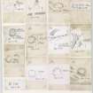
Publication drawings; 13 inked plans of sites (at a reduced scale), mounted on a single sheet. Includes Kirktonhill, Overhowden, Kelphope Burn, Longcroft, Knock Hill, Preston Cleugh, Ladykirk, Milne Garden, Ninewells, Oatlee Hill and Marygold Plantation (2). |
c. 1912 |
Item Level |
|
|
Photographs and Off-line Digital Images |
BW 5318 |
RCAHMS Aerial Photography |
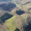
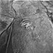
Oblique aerial view |
1983 |
Item Level |
|
|
Photographs and Off-line Digital Images |
BW 4153 |
RCAHMS Aerial Photography |
Oblique aerial view. |
1982 |
Item Level |
|
|
Photographs and Off-line Digital Images |
BW 4154 |
RCAHMS Aerial Photography |
Oblique aerial view. |
1982 |
Item Level |
|
|
Photographs and Off-line Digital Images |
BW 4155 |
RCAHMS Aerial Photography |
Oblique aerial view. |
1982 |
Item Level |
|
|
Photographs and Off-line Digital Images |
BW 5319 |
RCAHMS Aerial Photography |
Oblique aerial view. |
1983 |
Item Level |
|
|
Photographs and Off-line Digital Images |
BW 5320 |
RCAHMS Aerial Photography |
Oblique aerial view. |
1983 |
Item Level |
|
|
Photographs and Off-line Digital Images |
BW 5321 |
RCAHMS Aerial Photography |
Oblique aerial view. |
1983 |
Item Level |
|
|
Photographs and Off-line Digital Images |
D 28249 |
RCAHMS Aerial Photography |
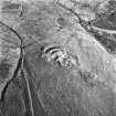
Oblique aerial view of Kelphope Burn centred on the fort and settlement, taken from the ENE. |
2/3/1998 |
Item Level |
|
|
Photographs and Off-line Digital Images |
D 28250 |
RCAHMS Aerial Photography |
Oblique aerial view of Kelphope Burn centred on the fort and settlement, taken from the NE. |
2/3/1998 |
Item Level |
|
|
Photographs and Off-line Digital Images |
D 28251 |
RCAHMS Aerial Photography |
Oblique aerial view of Kelphope Burn centred on the fort and settlement, taken from the NE. |
2/3/1998 |
Item Level |
|
|
Photographs and Off-line Digital Images |
D 28252 |
RCAHMS Aerial Photography |
Oblique aerial view of Kelphope Burn centred on the fort and settlement, taken from the NW. |
2/3/1998 |
Item Level |
|
|
Photographs and Off-line Digital Images |
D 28253 |
RCAHMS Aerial Photography |
Oblique aerial view of Kelphope Burn centred on the fort and settlement, taken from the NW. |
2/3/1998 |
Item Level |
|
|
Photographs and Off-line Digital Images |
D 28254 |
RCAHMS Aerial Photography |
Oblique aerial view of Kelphope Burn centred on the fort and settlement, taken from the WSW. |
2/3/1998 |
Item Level |
|
|
Photographs and Off-line Digital Images |
D 28255 |
RCAHMS Aerial Photography |
Oblique aerial view of Kelphope Burn centred on the fort and settlement, taken from the WSW. |
2/3/1998 |
Item Level |
|
|
Photographs and Off-line Digital Images |
D 28256 |
RCAHMS Aerial Photography |
Oblique aerial view of Kelphope Burn centred on the fort and settlement, taken from the SW. |
2/3/1998 |
Item Level |
|
|
Photographs and Off-line Digital Images |
D 28257 |
RCAHMS Aerial Photography |
Oblique aerial view of Kelphope Burn centred on the fort and settlement, taken from the SSW. |
2/3/1998 |
Item Level |
|
|
Manuscripts |
MS 36/1 |
Records of the Royal Commission on the Ancient and Historical Monuments of Scotland (RCAHMS), Edinbu |
Field notebook of A O Curle (RCAHMS). Titled 'Berwickshire 1908'. |
3/8/1908 |
Item Level |
|
 |
On-line Digital Images |
DP 224779 |
RCAHMS Aerial Photography Digital |
Oblique aerial view of the possible barrow and plantation bank with the fort beyond, looking SSW. |
17/2/2015 |
Item Level |
|
|
Prints and Drawings |
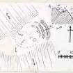
BWD 18/1/1 |
Records of the Royal Commission on the Ancient and Historical Monuments of Scotland (RCAHMS), Edinbu |
Publication drawing; plan and section, fort, Kelphope Burn. |
c. 1912 |
Item Level |
|
 |
On-line Digital Images |
DP 225484 |
Records of the Royal Commission on the Ancient and Historical Monuments of Scotland (RCAHMS), Edinbu |
Publication drawing; plan and section, fort, Kelphope Burn. |
c. 1912 |
Item Level |
|
 |
On-line Digital Images |
DP 225497 |
Records of the Royal Commission on the Ancient and Historical Monuments of Scotland (RCAHMS), Edinbu |
Publication drawings; 13 inked plans of sites (at a reduced scale), mounted on a single sheet. Includes Kirktonhill, Overhowden, Kelphope Burn, Longcroft, Knock Hill, Preston Cleugh, Ladykirk, Milne Garden, Ninewells, Oatlee Hill and Marygold Plantation (2). |
c. 1912 |
Item Level |
|
 |
On-line Digital Images |
SC 1743177 |
RCAHMS Aerial Photography |
Oblique aerial view. |
1982 |
Item Level |
|
 |
On-line Digital Images |
SC 1743178 |
RCAHMS Aerial Photography |
Oblique aerial view. |
1982 |
Item Level |
|


