Following the launch of trove.scot in February 2025 we are now planning the retiral of some of our webservices. Canmore will be switched off on 24th June 2025. Information about the closure can be found on the HES website: Retiral of HES web services | Historic Environment Scotland
Field Visit


Date 16 October 1908
Event ID 1088549
Category Recording
Type Field Visit
Permalink http://canmore.org.uk/event/1088549
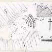
225. Fort, Kelphope Burn.
Situated on the top of a spur which projects into the Glen on the east side of the Kelphope Burn, directly above the Hazeldean Wood and about 1 ½ miles above the junction of the Hillhouse and Kelphope Burns, at an elevation of about 1000 feet above sea-level and 200 feet above the burn, is what appears to have been a circular or oval fort (fig. 112 [DP 225484]) with an interior diameter of about 223 feet , but the outline is indefinite. Towards the east end of the spur is a well-defined rampart, measuring 122 feet along its crest, 6 feet high towards the outside, and about 2 feet high on the inside. In rear of it is a trench or hollow 36 feet across, and in front of it the low and indefinite semblance of a second rampart. Low· mounds are visible on the north and south flanks, but are not traceable at the western extremity. In the interior is an elevated ridge of rock showing various depressions or considerable size on either side, but probably natural. Down the north flank a well-defined track leads to the Kelphope Burn. The flanks and end of the spur are steep and by nature-easily defensible.
RCAHMS 1915, visited 16th October 1908.
OS Map: Ber., xiii. NE. (unnoted).