
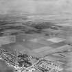
Port Seton, Harbour


Harbour (17th Century) - (Early 18th Century) (1679)-(1810), Harbour (Late 19th Century) (1880)
Site Name Port Seton, Harbour
Classification Harbour (17th Century) - (Early 18th Century) (1679)-(1810), Harbour (Late 19th Century) (1880)
Alternative Name(s) Port Seton Harbour
Canmore ID 54927
Site Number NT47NW 18
NGR NT 40487 75947
Datum OSGB36 - NGR
Permalink http://canmore.org.uk/site/54927


- Council East Lothian
- Parish Tranent
- Former Region Lothian
- Former District East Lothian
- Former County East Lothian
NT47NW 18.00 40487 75947
Location formerly cited as NT 404 759.
Not to be confused with Cockenzie Harbour (NT 39770 75694), for which see NT37NE 3.00.
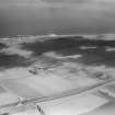
NT47NW 18.01 NT 40426 76001 and NT 40433 75981 to NT c. 40349 75924 West Breakwater
NT47NW 18.02 NT 40452 76002 and NT 40480 75975 to NT c. 40607 75957 North Breakwater
NT47NW 18.03 NT 40486 75952 to NT c. 40497 75876 Middle Pier
NT47NW 18.04 NT 40607 75944 Slipway
NT47NW 18.05 NT 40457 76003 Leading Light (Beacon)
NT47NW 18.06 NT 40474 75995 Monument
Port Seton Harbour [NAT] (name centred NT 40433 75936)
Port Seton Harbour [NAT] (name centred NT 40536 75943)
OS (GIS) AIB, July 2006.
NMRS REFERENCE:
ENGINEER: D. & G. Stevenson 1892.
(Undated) information in NMRS.
A harbour was built at Port Seton at some date after 1635, and lasted till 1810. It is said to have been ruined in that year, but a pier with its head turned westwards is marked on Knox's map of Midlothian (1812) and on Thomson's map of Haddington (1822). Nothing of the earlier work survives, although a dump of large stones believed locally to have come from it, may be seen on the foreshore just E of the landward end of the pier, and the footings of a jetty, of unknown age, are said to be buried under the SW end of the beach in the landward sector of the basin.
Adair (1703) described the place as 'a good Tide Haven, being covered from the N and NE winds by a hudge Pier of stone', while his map of E Lothian suggests a curved breakwater on the E and rocks on the W.
The existing harbour, built in 1879-80, shows a rather similar plan, which is more or less dictated by the site.
A Graham 1971.
There is no trace of an earlier harbour.
Visited by OS (BS) 14 October 1975.
(Location cited as NT 404 759). Port Seton Harbour, built 1879-80. Formed by 2 piers with angled heads and a central pier, giving 2 basins.
J R Hume 1976.
Port Seton Harbour, reopened and enlarged by D and T Stevenson from 1880, with the aid of Lord Wemyss.
C McWilliam 1978.
The existing harbour was built 1879-80 and consists of an east and west breakwater and a central pier forming two docks. No remains of the earlier harbour are visible. Port Seton harbour is still in use by small pleasure craft and fishing boats and is well maintained. The south wall has been recently refurbished and the SW corner shows some evidence of erosion and attempts to combat this by using stone filled wire cages. The south edge of the harbour is now a carpark and benches have been placed along the harbour wall.
Site recorded by GUARD during the Coastal Assessment Survey for Historic Scotland, 'The Firth of Forth from Dunbar to the Coast of Fife' 22nd February 1996.

