
Elginhaugh


Fort Annexe (Flavian), Roman Fort (Flavian)
Site Name Elginhaugh
Classification Fort Annexe (Flavian), Roman Fort (Flavian)
Alternative Name(s) Elginhaugh Bridge
Canmore ID 53492
Site Number NT36NW 61
NGR NT 32134 67346
Datum OSGB36 - NGR
Permalink http://canmore.org.uk/site/53492


First 100 images shown. See the Collections panel (below) for a link to all digital images.
- Council Midlothian
- Parish Dalkeith
- Former Region Lothian
- Former District Midlothian
- Former County Midlothian
NT36NW 61.00 32134 67346
NT36NW 61.01 NT 321 673 Settlement (possible); Pottery
NT36NW 61.02 NT 321 673 Flints
NT36NW 61.03 NT 321 673 Beaker
For Roman bath-house at NT 3215 6721, see NT36NW 83.
For (Lugton) Roman temporary camp around NT 32527 67433, see NT36NW 97.
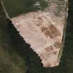
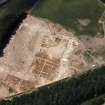
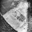
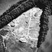
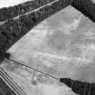
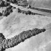
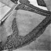
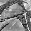
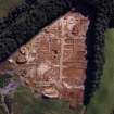
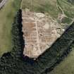
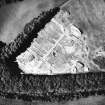
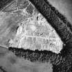
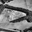
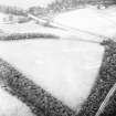
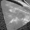
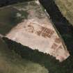
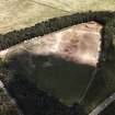
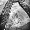
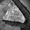
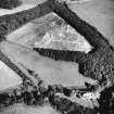
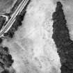
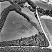
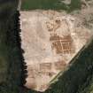
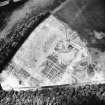
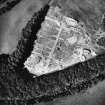
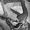
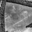
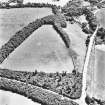
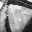
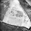
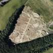
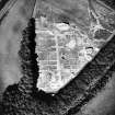
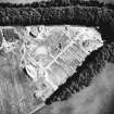
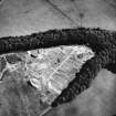
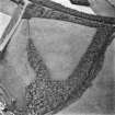
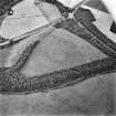
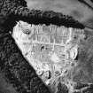
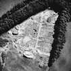
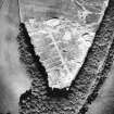
NT 321 673 Roman Fort (and Roman Road), Elginhaugh: visible on aerial photographs. This fort has been confirmed by excavation as of Flavian date. See also NT36NW 83.
(Undated) information in NMRS.
Excavation (1986 - 1989)
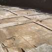
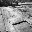
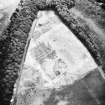
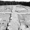
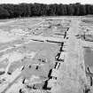
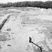
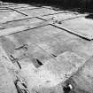
The fort was completely excavated in 1986 and shown to be of Flavian date. It covered an area of 1.26 ha within a turf rampart from 6m to 8m thick, defended by three or four ditches. Six-post towers flanked each of the four gateways and there were also towers at the corners and at intermediate positions in the rampart. All but one of the buildings in the interior were of timber; there was a central range, comprising the headquarters building, the commandant's house and two granaries, and there were barrack-blocks and storage buildings to both front and rear. A building with stone footings, set against the back of the rampart at the NE corner, may have been a workshop; several stone-built ovens had also been set against the rampart and there was a system of stone-lined drains along the roads. The fort had been deliberately demolished, although there is some evidence for a brief re-occupation. The finds include pottery, glass, a steelyard, a bronze patera, a bronze key, an iron shield boss, a cache of unused nails and a hoard of 41 denarii, the latest of AD 77-8. The latest coin from the fort is an unworn sestertius of AD 86.
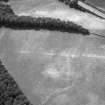
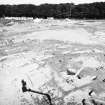
In 1987 excavation in advance of development was conducted in selected areas within the annexe. Occupation had been concentrated alongside the road which ran through the annexe from the W gate of the fort. Three major resurfacings indicated that traffic had been quite heavy. Four main phases of activity were revealed. The earliest involved a number of oven or furnace features, probably associated with grain processing. These ovens seem to have gone out of use and were replaced by timber strip-buildings fronting onto the road. Thereafter the roadside area seems to have been given over to cooking ovens before being cut off from the rest of the annexe by two ditches which created a funnel leading from the outer ditches of the fort to the annexe gateway. The arrangement may have been related to the movement of animals.
W S Hanson 1987; W S Hanson and P A Yeoman 1988; RCAHMS 1988.
Note (1988)
Elginhaugh, Fort, Annexes and Bathhouse NT 32 67 NT36NW 61 & 83
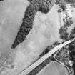
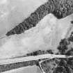
In 1979 air photography revealed the existence of a Roman fort on the left bank of the River North Esk to the NW of Dalkeith; it is set on the crest of a steep scarp 250m N of Elginhaugh Bridge. Subsequently an annexe was identified on the NW side of the fort and a bathhouse at the foot of the scarp to the S.
(1) NT 321 673. The fort was completely excavated in 1986 and shown to be of Flavian date. It covered an area of 1.26ha within a turf rampart from 6m to 8m thick, defended by three or four ditches. Six-post towers flanked each of the four gateways and there were also towers at the corners and at intermediate positions in the rampart. All but one of the buildings in the interior were of timber; there was a central range, comprising the headquarters building, the commandant's house and two granaries, and there were barrack-blocks and storage buildings to both front and rear. A building with stone footings, set against the back of the rampart at the NE corner, may have been a workshop; several stone-built ovens had also been set against the rampart and there was a system of stone-lined drains along the roads. The fort had been deliberately demolished, although there is some evidence for a brief re-occupation. The finds include pottery, glass, a steelyard, a bronze patera, a bronze key, an iron shield boss, a cache of unused nails and a hoard of 41 denarii, the latest of AD 77-8. The latest coin from the fort is an unworn sestertius of AD 86.
Pre-Roman material was also found during excavation; this included large numbers of Mesolithic flints from beneath the rampart on the W side of the fort, and pottery of probable late Bronze Age or early Iron Age date from a number of shallow pits sealed by part of the intervallum road on the E; the pits contained quantities of burnt material and, in one case, some grains of barley. A turf-line visible beneath the rampart and roads suggests that the area was under pasture when the fort was constructed, although ardmarks were recorded at a number of points.
In 1987 further excavations were conducted in the annex on the NW, where a complex structural sequence was revealed, but no further details are yet available.
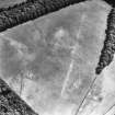
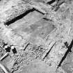
(2) NT 3212 6718. The bathhouse, which is presumably enclosed by an annexe attached to the fort, measures 23m from E to W by 7 .5m transversely. It is divided into three square rooms with a projecting apse at the Wend. Trial excavation showed that the walls of the bathhouse still stand up to 1.1m in height in eleven courses (see also NT26NE 28).
RCAHMS 1988
(Maxwell 1983, 172-7; DES (1984), 18; Frere 1985, 264-5; Hanson 1987)
Archaeological Evaluation (19 March 2007 - 27 July 2007)
NT 3222 6748 A programme of archaeological works was undertaken between 19 March–27 July 2007 at Melville Gate Data Centre in connection with a planning condition issued by Midlothian Council. This comprised an archaeological evaluation of land within the grounds of the data centre, to the N and W of the current building. The present building and its grounds are located on the site of a Roman fort and annexe (NT36NW 61).
The area to the N appears to have been built up by imported topsoil. The subsoil within this area appeared to be intact. The area to the W of the fort, within the known location of the annexe, had been severely truncated by ground works during the construction of the data centre. Further archaeological investigations were carried out to clarify the status of the annexe ditch. The original evaluation trenches were extended to the E. Two ditches were uncovered and Roman amphora and tile were recovered from one of the ditches. Although the area to the W is heavily truncated there is potential for partial survival of Roman features.
Archive and report to be deposited with RCAHMS. Report deposited with Midlothian SMR.
Funder: RBS Group.
Excavation (2 March 2009 - 20 March 2009)
NT 3215 6740 An excavation was undertaken 2–20 March 2009 prior to building work at the Melville Gate Data Centre. The Centre is on the site of a Roman fort known as Elginhaugh, which was identified and partially excavated in the 1980s. The annexe of the fort had not been fully investigated and results from an evaluation carried out in 2007 suggested that elements of the annexe survived in the footprint of the proposed development.
An excavation of the remaining area of the annexe revealed a series of ditches and a post-built gateway. Other previously unknown features included a well, a putative roadside building and ditches subdividing the interior of
the annexe. A coin of the Emperor Trajan (AD 97–117) was discovered in the backfill of an enclosure ditch, a decade later in date than any previous coin found in the annexe or fort.
Archive: RCAHMS (intended). Report: Midlothian SMR and RCAHMS
Funder: Royal Bank of Scotland Group
Candy Hatherley – Headland Archaeology Ltd

