
Dalkeith, 176 - 180 High Street, Market Place, Tolbooth


Church Hall (20th Century), Tolbooth (17th Century)
Site Name Dalkeith, 176 - 180 High Street, Market Place, Tolbooth
Classification Church Hall (20th Century), Tolbooth (17th Century)
Alternative Name(s) Scientific Hall; Church Hall; Former Tolbooth
Canmore ID 53476
Site Number NT36NW 47
NGR NT 33323 67436
Datum OSGB36 - NGR
Permalink http://canmore.org.uk/site/53476


- Council Midlothian
- Parish Dalkeith
- Former Region Lothian
- Former District Midlothian
- Former County Midlothian
NT36NW 47 33323 67436.
(NT 3332 6743) Scientific Hall (NAT)
formerly Jail or Tolbooth (NR)
OS 1:500 map (1893)
Dalkeith Tolbooth, now the Scientific Hall, is a 17th c Renaissance structure of two storeys above ground and a basement containing prison cells beneath the pavement. It is oblong on plan, 53'2" x 21'3", and the masonry to the street is ashlar. The stone over the doorway, bearing the Scott of Buccleugh arms and dated 1648 is not in situ, having been brought there in the 18th c from the grounds of Dalkeith Palace. Dalkeith was erected into a Burgh of Barony in 1540. Baron Baillie held his court in the upper storey and administered the town's affair until 1878 when it elected to become a police burgh.
RCAHMS 1929, visited 1915; NSA 1845; SDD List 1964
Dalkeith Tolbooth is as described and is in good order.
Visited by OS (BS) 30 October 1975
An oblong symmetrical structure with a pedimented doorway with 1648 datestone, but otherwise of later appearance.
G Stell 1982; NMRS MLD/26/1-2 (1958-9)
Field Visit (29 July 1915)
Dalkeith Tolbooth.
The Tolbooth, now put to other uses, stands in the main street, opposite St Nicholas' Church and adjoining the Cross Keys Hotel. It is a 17th-century Renaissance structure of two storeys above ground with subterranean cells beneath the pavement. It is oblong on plan, measuring 53 feet 2 inches from north to south by 21 feet 3 inches from east to west. The masonry to the street is of ashlar with rusticated quoins. At eaves-level there returns a moulded cornice. The entrance doorway has a cartouche within the pediment bearing on a bend a mullet between two crescents, for Scott of Buccleuch.
A panel above the doorway bears, beneath coronets, the initials F.E.B. for Francis, 2nd Earl of Buccleuch, and M.C.B. for Margaret (Leslie), Countess of Buccleuch, and the date 1648. The panel is probably not in situ. The other sides of the structure are built of rubble and harled.
RCAHMS 1929, visited 29 July 1915.
Publication Account (1996)
This two-storeyed building' stands on the E side of High Street, almost opposite the medieval parish church of St Nicholas and abutting the Cross Keys Hotel. lt is rectangular on plan, measuring 16.3m by 6.5m, and is covered by a hipped and slated roof from which the chimney-stacks have been removed. The ashlar-built main (W) front has a central doorway and three bays of symmetrically-disposed windows to each side, but the ground-floor N window occupies the position of a former doorway. The base-course is chamfered and there are rusticated angle-quoins and a moulded eavescornice. The Sand E walls are of harled rubble. The building may be ascribed to the 17th century but it has undergone extensive later alterations.
The most distinctive feature of the main front is the doorway, which has a bolection-moulded surround and a pediment containing the arms of Scott of Buccleuch: on a bend a mullet between two crescents. Above the pediment there is a panel carved with two coronets above the initials E/FB and C / MLB and the date 1648. The initials are those of Francis, 2nd Earl of Buccleuch, and his wife Margaret Leslie, and the panel is said to have been brought from the grounds of Dalkeith Palace in the late 18th or early 19th century.
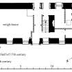
Internally the building is divided by a substantial cross-wall into a square S room and a larger rectangular N room on each floor. Against the N side of this wall a straight stair rises to the first-floor S room and continues with a dog-leg turn to the N room and a smaller room at the centre of the W front.While the moulded stone treads of its straight portion appear to be original, the wall abutting it to the N, and all the other internal walls with the exception of the cross-wall itself, appear to be additions to the original structure.
Beneath the S ground-floor room there is a flat-ceiled pit with earthen floor and rubble walls, some 2m square, known as the 'black hole'. It is entered by a trap-door in the floor of the room above, which was previously used as a prison, as was the corresponding first-floor room. The main ground-floor room served as a weigh-house on market-days, and that at first-floor level as a court-room. The interior of the building retains few early features, all fireplaces having been removed or blocked, and there have been various other modern alterations, notably to the openings of the rear (E) wall.
HISTORY
A tolbooth existed in Dalkeith in 1616,6 and although the 1648 date-panel is apparently not in situ, the present building probably belongs to the second half of the 17th century. In 1759 it was considered 'to have been the private prison and court house of the Regality ofDalkeith and the property of the family of BuccIeuch ... past all memory'. The appearance of the main front suggests that extensive refacing has been undertaken, probably in the 19th century. In 1759 consideration was given to converting part of the tolbooth to a school, but it continued to be used regularly as a jail until 1841. From 1835 the tolbooth housed the meetings and library of the Dalkeith Scientific Association, and it came to be known as the 'Scientific Hall'. In 1966 it was refurbished as a church hall by the Kirkcaldy architects Armstrong and Thomas." In front of the building are stones marking the site of the burgh gibbet.
Information from ‘Tolbooths and Town-Houses: Civic Architecture in Scotland to 1833’ (1996).
Publication Account (1998)
Dalkeith 's tolbooth (176- 180 High Street, also designated a Scheduled Ancient Monument) figures 12 & 21 .A, fronting the widened High Street, the site of the market place (see pp 66-9), is a visual reminder of the crucial role that the market held in Dalkeith 's past. It was in the tolbooth that market dues were collected and the public weigh-beam was housed. The present building was erected in the late seventeenth century, probably being reworked to some extent in the eighteenth century, and retains many of its original exterior features, although the frontage was probably refaced in the nineteenth century. The whole building underwent refurbishment in 1966. The panel above the doorway, inscribed with the elate 1648 and the arms of the earl of Buccleuch, is misleading. It was discovered in the grounds of Dalkeith Palace in the late eighteenth century, and only at that time placed on the tolbooth facade. The tolbooth also functioned as the town's court house, the court room on the first floor having a coffered ceiling. It was here, also, that the town's prison was housed. This consisted of a pit prison in the subterranean basement and an upper prison. Dalkeith's gibbet stood in front of the tolbooth, where the second last public hanging in Scotland took place in 1827.
Information from ‘Historic Dalkeith: The Archaeological Implications of Development’ (1998).
Fabric Recording (7 March 2012 - 29 May 2012)
Addyman Archaeology was contacted by Kenneth Ferguson (of Kenneth Ferguson and Partners) on behalf of the Dalkeith Townscape Initiative and Conservation Area Regeneration Scheme (DTHI/CARS) project1 (contact, Rod Lugg, Project Manager) to undertake archaeological recording and monitoring works in relation to the refurbishment of the exterior of Dalkeith Tolbooth, Dalkeith, Midlothian. The works were undertaken according to the designs of Stephen Newsom, project architect. These works involved the stripping of a thick cement harling on the rear (southeast) wall and gable wall to the SW; this was to be replaced with a more appropriate lime-based harl application. Extensive areas of cement repair were also to be removed from the NW-facing ashlar-faced street frontage, this to enable structural assessment, repair and an extensive programme of necessary stoneindenting. East Lothian Council Heritage Service (contact, Andy Robertson), as archaeological advisors to Midlothian Council, placed a condition on the consent for the works requiring historic building recording and on-going archaeological monitoring during works. Following on-site discussions with Andy Robertson it was agreed that the recording work was to include a preliminary drawn overlay onto the architect's as-existing elevation of the street frontage prior to stripping of more recent areas of repair, and thereafter a full drawn record of the frontage following stripping (but before stoneindenting commenced), and a drawn record of the rear wall and side following harl removal.
Addyman Archaeology (T. Addyman, K. MacFadyen, N. Uglow) OASIS ID: addymana1-137530
Standing Building Recording (7 March 2012 - 29 May 2012)
NT 3332 6743 A programme of historic building recording and monitoring was undertaken, 7 March – 29 May 2012, during conservation work on Dalkeith Tolbooth. The work involved the removal of cement harl from the rear (SE) elevation and SW gable wall, its replacement with lime harl, and extensive repair by stone indenting of the ashlar-faced street frontage to the NW, the latter much patched with cement.
The work revealed significant new evidence for the former appearance of the tollbooth. The frontage in particular was significantly different in detail to its subsequent appearance. The work defined the extent of surviving original fabric and confirmed it to have been of one overall build, which did not incorporate the in situ remains of pre-existing structures. The various lifts visible on the rear and side elevations indicate that the build occurred in three principal stages. The rear elevation also revealed the presence of two original first floor windows and the probable site of an entrance at ground floor level.
The overall design of the building was of notable sophistication. The detailing and execution of the ashlar-faced street frontage was of superlative quality, with many finely nuanced constructional features and an assurance of composition (in spite of the asymmetry of some elements – a symptom of the functional nature of the building), which clearly suggests the hand of a significant architect. Elements of the original construction, such as the majority of the ground floor openings, including the principal entrance, a first floor centrepiece and the details of its roof-scape were evidently missing or considerably altered.
A number of secondary works were recorded. Of particular significance was an early recasting of the principal frontage where the main entrance, the ground and upper floor windows, and the panel above the entrance all saw significant modification. This work may have occurred in the mid- or later 18th century and may have been associated with the reordering of the building internally. Perhaps associated were modifications evident to the rear; these were principally associated with the addition of a shallow two-storey extension which may have contained a stair. A further lean-to construction had been added to the NE.
Archive: RCAHMS
Funder: Dalkeith Townscape Heritage Initiative
Kenneth Macfadyen and Tom Addyman, Addyman Archaeology, 2013
(Source: DES)

