
Dun Mhaigh


Broch (Iron Age)
Site Name Dun Mhaigh
Classification Broch (Iron Age)
Alternative Name(s) Dun Haig; Dun Maigh; Dun Na Maigh
Canmore ID 5345
Site Number NC55SE 1
NGR NC 5523 5303
Datum OSGB36 - NGR
Permalink http://canmore.org.uk/site/5345


- Council Highland
- Parish Tongue
- Former Region Highland
- Former District Sutherland
- Former County Sutherland
NC55SE 1 5523 5303.
(NC 5523 5303) Dun Mhaigh (NAT) Broch (NR)
OS 6" map (1961)
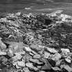
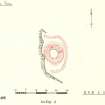
The remains of a broch, Dun na Maigh, strongly situated on a prominent rock rising from the ridge. The rock face is precipitous on the W and abrupt on the E, but from the N and S the approaches are easier and have been defended by walls enclosing the level areas adjoining the broch. There is a chasm on the W face of the rock, the upper part of which is built up. The broch itself is not circular, the W side set back several feet from the edge being considerably flattened and appearing to have been reconstructed. It measures about 31ft N-S by 27ft E-W within a wall 16ft thick which stands 8ft in maximum height. The entrance passage in the E is checked and has three or four roofing slabs in situ. There is no sign of a guard chamber. In the NW arc is a mural chamber 8ft long, roofed with flags, and entered beneath a lintel about 3ft long. Immediately to the E is another chamber 5ft long and 3ft wide, built up at the end and filled with stones.
RCAHMS 1911, visited 1909
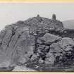
Although mainly a tumbled mass of stones, this broch is well-preserved on the S, where both inner and outer wall-faces are definable, the latter being about 2m high. A small guard-chamber is visible on the N side of the entrance, but the other chambers have collapsed. The wall to the S of the broch, is of rubble, 0.3m high, and appears to have formed an annexe or courtyard rather than a defence. There are traces of a similar enclosure to the N.
Visited by OS (JLD) 22 April 1960
Dun Mhaigh, a broch, is generally as described. The entrance passage is double checked with the guard chamber visible between the checks. In the wall core in the NW quarter is visible a flight of eight steps and, at or near ground level, the remains of a mural chamber opening onto the steps. There are fragments of a scarcement ledge, 0.3m wide, on the S side of the broch. The alleged annexes or enclosures are probably the remains of a single defensive wall fronting the N, E and S approaches to the broch, and terminating at both ends on the steep rock face on the W side.
Revised at 1:10,000.
Visited by OS (JM) 11 October 1978
Publication Account (1995)
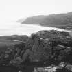
Dun na Maigh is built on a rocky knoll at the north end of a ridge overlooking the Kyle of Tongue, with a fine view over the estuary and the hills either side.
On the west side the ridge is precipitous, but to the north and south the slopes are less steep and the remains of an outer defensive wall can be seen.
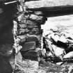
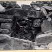
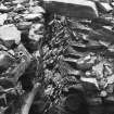
The broch has collapsed, but much of the remaining wall stands clear of the surrounding tumble, and several characteristic features can be seen. The entrance is on the east, with some lintels still in place. There are two sets of door checks for two wooden doors, and the door to a blocked cell between them on the right, but the fallen stone in the entrance passage has not been cleared down to fIoor level. Inside, again on the right, is a door leading to the remains of a cell in the wall on the left, and a stair on the right. One lintel remains in place at the top of the stair. Opposite the stair there seems to be a doorway to some other feature, now blocked. A short stretch of modern wall has been built near the stair.
Information from ‘Exploring Scotland’s Heritage: The Highlands’, (1995).
Publication Account (2007)
NC55 1 DUN NA MAIGH ('Dun Mai', ‘Dun Maigh’)
NC/5523 5303 (NC/5524 5321 – GPS)
This broch in Tongue, Sutherland, has been partly cleared out and is in a prominent and strategically well situated position (visited 10/7/63, 19/7/85 and 22/7/03). It stands in a dramatic situation on a high knoll of rock at the front or north end of a long ridge which divides the valley of the Kyle of Tongue at its inland end and projects into it. The site looks down on to the estuary and has an extensive view both over this and over the fertile land of the Kinloch river valley to the east. The rock knoll is precipitous on the west with a height of 15.25m (50ft) or more and there is an abrupt slope on the east where the entrance is. On the north and south the approaches are easier but they are blocked by outer defensive walls. The broch itself is evidently built on sloping rock with the entrance passage on the downhill side on the east-south-east.
There is a V-shaped cleft in the face of the cliff on the west (at about 12 o'clock) the upper part of which is built up to support the broch wall, a few feet back from its edge. At the foot of the cliff below this cleft is a huge pile of rubble, fallen from the broch, and the structure itself, from about this point to perhaps 2 o'clock, appears to be badly collapsed. It may be that the upper part of the masonry on the cleft gave way – perhaps while the broch was in use – and caused a major outward collapse of the wall on the west. If this broch is ever excavated an exploration under this rubble heap might prove rewarding, especially if the first collapse was ancient.
A scarcement of the ledge type is visible on the inner wallface at about 10.30 o'clock and at this point it is little more than about 1.0m above the level of the rock outside. Its width is 23-30.5cm (9-12in) and it is partly corbelled. However this ledge can be seen to be from 1.50 to 1.60m above the top of the remaining entrance lintels (measured with an alidade) so the surface of the rock at the entrance is clearly well below that on the opposite side. If one supposes that the passage lintels are about 1.7m above the rock at the inner end, a level scarcement will here have been about 3.70m above the floor (it is now destroyed in this segment of the wall). The situation at Dun na Maigh is thus likely to be rather similar to that at Caisteal Grugaig in Wester Ross (NG82 1) where a level scarcement also comes close to the interior rock floor on the uphill side and is much higher at the entrance on the downhill side. Assuming the ledge to have been level there can be little doubt that this is a true, hollow-walled broch.
The entrance passage itself is 5.03m (16.5ft) long and has been cleared out since 1909 [2]; several of the passage lintels are in position. Two sets of door-checks are visible, with a doorway leading to an oval guard cell in the right wall between them (invisible in 1909). The cell itself is partly corbelled but with a roof of flat lintels. The front door-frame has checks of built masonry and a bar-hole is behind them in the left wall. The checks of the rear door-frame are built of stone slabs set into the walls at right angles but these are now broken off short.
There are clear signs that the inner end of the passage has been partly rebuilt. The innermost right corner is a complete reconstruction and sits about 20cm in from the actual corner and resting on loose rubble; the lintel now over the inner end is supported by it.
The interior of the broch is full of debris but parts of the inner wallface are exposed. At about 2 o'clock is visible a long intra-mural space the left-hand part of which is a corbelled cell, choked with debris, and the right-hand section of which contains the stairway (the steps of which were not visible in 1963) rising to the right. One or two lintels are still in position above it but were probably replaced when the stair passage was exposed. The doorway leading into the wall here from the central court was not apparent in 1985 but had been partly exposed by 2003. In the outer face of the intra-mural gallery, and presumably opposite where the doorway should be and facing it, is a curious large double-tiered aumbry, next to the bottom step of the stair; its design is almost exactly the same as that in the Achvarasdal Lodge broch (NC96 3). By 2003 the upper opening had been carefully blocked with laid slabs.
Also after 1985 some extensive rebuilding must have been undertaken to the inner wallface anti-clockwise from the stair door. A considerable amount of rubble had been removed from this face for the purpose. This face now curves round into the interior (in a 'pit' in the rubble) and partly blocks the stair door. This site is urgently in need of proper consolidation, and of protection from uninformed digging and 'restoration'.
There are traces of what is probably a single defensive outer wall protecting the broch on the north, east and south sides [1].
Dun na Maigh is a rare example of a broch which has been examined by a geologist – Kevin O’Reilly.
“The local rock is a coarse-grained garnet mica schist, packed with large silvery flakes of muscovite (mica) and studded with dark reddish brown crystals of garnet. You will find that the broch itself is built from a very different rock; finer grained and largely made of quartz and feldspar, with only minor amounts of muscovite in tiny flakes. This material must have been quarried elsewhere and carried up the slope to the broch site – no easy task as the total weight involved was over a thousand tons.” [4]
The stones in the broch resemble sandstone in the sense that many are even and brick-like in shape.
Dimensions: the structure's external diameter through the entrance measures 18.61m (61ft) , the internal one 8.44m (27ft 8in). At right angles to this the measurements are respectively 18.91m (62ft) and 9.38m (30ft 9in): the average wall proportion is 52.8%.
Sources: 1. NMRS site no. NC 55 SE 1: 2. RCAHMS 1911a, 183-4, no. 527: 3. Close-Brooks 1986, 150-1, no. 81: 4. O’Reilly and Crockford 2005, Locality 14.
E W MacKie 2007
Note (7 February 2015 - 31 May 2016)
Dun Mhaigh is a broch standing within an outer wall on the summit of a hillock which falls away sheer some 15m on the W and fairly sharply on the E. The broch itself measures about 8.4m in diameter within a wall about 5m thick and the architectural features visible include a mural chamber with stair, a scarcement and a double-checked entrance passage with a guard chamber on the ENE. The summit of the hillock is also enclosed by an outer wall, which can be traced as a band of rubble around the N, E and W, forming an irregular enclosure backing onto the cliff-edge and measuring internally about 34m from NNE to SSW by 21m transversely (0.07ha). The entrance is not visible and the interior is largely occupied by the broch. The relationship between the broch and the outer wall is unknown.
Information from An Atlas of Hillforts of Great Britain and Ireland – 31 May 2016. Atlas of Hillforts SC2794

