
Pricing Change
New pricing for orders of material from this site will come into place shortly. Charges for supply of digital images, digitisation on demand, prints and licensing will be altered.
Cousland Castle


Castle (Medieval), Garden (17th Century), House (16th Century)
Site Name Cousland Castle
Classification Castle (Medieval), Garden (17th Century), House (16th Century)
Alternative Name(s) Cousland Nunnery; Cousland House; Chapeldyke
Canmore ID 53403
Site Number NT36NE 9
NGR NT 37738 68389
Datum OSGB36 - NGR
Permalink http://canmore.org.uk/site/53403


- Council Midlothian
- Parish Cranston
- Former Region Lothian
- Former District Midlothian
- Former County Midlothian
NT36NE 9 37738 68389
(NT 3774 6837) Castle (NR) (rems of)
OS 6" map (1967).
See also NT36NE 13.
Location formerly entered as NT 3774 6837.
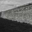
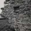
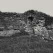
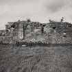
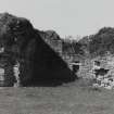
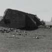
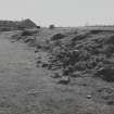
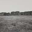
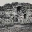
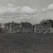
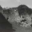
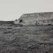
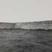
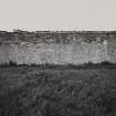
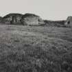
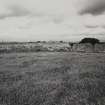
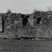
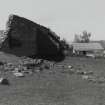
The remains at this site form an enclosure, 224' square within walls 2'10" thick; the masonry suggests 17th century work. At the NE corner is a very ruinous 17th century house, of which the part that projects within the enclosure appears to be earlier than the portion lying parallel to and incorporated in the E wall. This older portion is a structure 30' wide and of indeterminate length and layout. This site was originally published by the OS as "Supposed site of Nunnery", and it has been scheduled as "Cousland Nunnery". However, Easson makes no mention of the existence of a nunnery here, and the RCAHMS state that though the older part of the building noted above is orientated, in no other way is it suggestive of an ecclesiastical purpose. They consider that the remains are probably those of Cousland Castle, which is indicated on diagrams of the Battle of Pinkie in Patten's "Expedicion into Scotlande". (See also NT36NE 13).
RCAHMS 1929, visited 1921; D E Easson 1957
These remains are as described except that the S wall of the enclosure and part of the N wall have been demolished.
Visited by OS (BS) 22 October 1975.
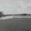
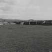
NT 377 683 An area of ground resistance survey was started on 23 September over a levelled field to the W of Cousland Castle (NT36NE12). The castle, a possible tower house, stands to the S of Cousland village some 60m to the E of a small road that runs S to join the A68. A large stone wall runs for over 100m N beside this road before turning through a right-angle to butt on to the side of the castle; the wall effectively encloses the surveyed area. Seven 20 x 20m squares were surveyed and the printout showed high and low resistance lines adjacent to the castle suggesting an extension or outbuildings to its W. Slight high and low resistance lines run parallel with the W wall and, as there are socket holes in the wall, could indicate a lean-to structure.
The squares to the S show strong high and low resistance amorphous shapes, possibly indicating limestone bedrock. One sharply angled low resistance could be an infilled limestone extraction pit. Further survey is planned to take place in 2007.
Sponsor: D Connolly, British Archaeological Jobs Resource, Cousland Historical Society, Edinburgh Archaeological Field Society.
HMD Jones 2006.
Schedulked as 'Cousland Castle, tower and house 75m ESE of Chapeldyke... [comprising] the remains of a tower house, a later building that adjoined it to the south, and part of a garden wall.'
Information from Historic Scotland, scheduling document dated 25 June 2011.
Castle
(remains of) [NAT]
OS (GIS) MasterMap, June 2011.
EXTERNAL REFERENCE
Reg. Mag. Sig (1542) No.2769
Inquis. Spec. Edin., No.1057.
(Undated) information in NMRS.
Field Visit (27 April 1921)
Cousland Castle (?).
In the high upland village of Cousland are some remains which are noticed as follows in the Statistical Account (ix, 281): ‘On the south side of this village, are to be seen the ruins of some buildings, with two enclosures surrounded by high walls. No authentic account of them, after much research, can be found; but if we may credit tradition, they are the remains of a nunnery. The highest wall, commonly called the White Dike, at present measures 24 feet, and the rest vary in height from 5 to 11. The inclosures were undoubtedly orchards, since cherry trees and gooseberry bushes were still growing a few years ago. That there was a churchyard here, and a bell to be seen hanging in the end of the chapel, till it was carried off by some tinkers, are facts supported by the testimony of persons still alive. Hence it is probable, that it was a religious foundation, and perhaps dedicated to St Bartholomew, since there are some acres of ground to the southward. which retain the name of Bartholomew's Firlot’.
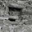
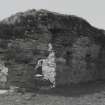
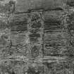
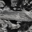
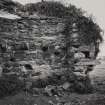
The remains now form an enclosure, 224 feet square within walls 2 feet 10 inches thick, which stands complete to a height of 24 feet, at the north-west angle only. This enclosure was undoubtedly a garden or orchard, and the masonry suggests 17th century work. At the north-east corner is a very ruinous late 16th-century house of which the part that projects within the enclosure appears to be earlier than the portion lying parallel to and incorporated in the east wall. This older portion is a structure 30 feet wide and of indeterminate length and height. Its basement was ceiled with a barrel-vault, beneath which, at springing level, was a timber floor with joists borne on massive corbels 11 inches wide and high, that project 8 inches from the wall face. The upper chamber had at least one window, which was centred in the west gable. The lower chamber was the kitchen; of its great fireplace very little is left, and the spring of its arch can just be traced; its position is unusual, as it lies in the north lateral wall. In the surviving jamb of the fireplace is an inlet for water, with the external orifice 6 feet above the present ground-level and the inner opening breast-high. The channel, 8 inches wide, contracts to 2 ½ inches at the mouth. West of the jamb is a slop outlet. The kitchen has two small aumbries in the gable and two small windows looking southwards into the enclosure. The entrance lies in the south wall immediately south of the enclosure, and of it one jamb remains; its margin is chamfered and is rebated in rear for two doors, both opening inwardly. The inner was secured by a drawbar. What appears to be an addition to this structure can be traced in the east wall of the enclosure. It had a length of 79 1/3 feet, but height, width, and arrangement are indeterminate. Against the north wall of the enclosure, towards the western end, are several ruinous structures; these are secondary.
The older portion of the house is certainly orientated, but in no other particular does the structure suggest an ecclesiastical purpose; the remains are therefore probably those of Cousland Castle, which is indicated on diagrams of the Battle of Pinkie in Patten's 'Expedicion into Scotlande'.
HISTORICAL NOTE. Cousland belonged to the St. Clairs of Roslin (1). But in 1656 Robert MacGill, son of Sir James MacGill of Cranston Riddell, was returned heir to his brother in the lands and barony of Cousland (2).
RCAHMS 1929, visited 27 April 1921.
(1) Cf. Reg. Mag. Sig. (1542), No. 2769; (2) Inquis. Spec., Edinb., No. 1057.
OS Map: viii N.E. (unnoted)
Earth Resistance Survey (23 September 2006)
NT 377 683 An area of ground resistance survey was started on 23 September over a levelled field to the W of Cousland Castle (NT36NE12). The castle, a possible tower house, stands to the S of Cousland village some 60m to the E of a small road that runs S to join the A68. A large stone wall runs for over 100m N beside this road before turning through a right-angle to butt on to the side of the castle; the wall effectively encloses the surveyed area. Seven 20 x 20m squares were surveyed and the printout showed high and low resistance lines adjacent to the castle suggesting an extension or outbuildings to its W. Slight high and low resistance lines run parallel with the W wall and, as there are socket holes in the wall, could indicate a lean-to structure.
The squares to the S show strong high and low resistance amorphous shapes, possibly indicating limestone bedrock. One sharply angled low resistance could be an infilled limestone extraction pit. Further survey is planned to take place in 2007.
Sponsor: D Connolly, British Archaeological Jobs Resource, Cousland Historical Society, Edinburgh Archaeological Field Society.
H M D Jones 2006
Excavation (11 November 2007 - 11 July 2008)
NT 3770 6830 – NT 3700 6770 – NT 3770 3810
Area 1: The Castle field – We have confirmation that the castle is likely to have been built by the Ruthven lords around the end of the 15th century. Later, they constructed a residence, which hosted the Confederate Lords, and perhaps even Mary Queen of Scots, in 1567. The walled garden was built much later in the early 18th century and in the process quarried away most of the castle, though the residence remained until at least 1760. There is definite proof of structures in the S field, though these may be connected with later quarry works. The residence, although demolished, does have surviving archaeology to the S, and could provide evidence of construction, use and layout.
Area 2: The Pottery field – Examination of the pottery and kiln furniture recovered in the fieldwalking, and
from the small evaluation trench confirm the presence of surviving archaeology. We are now sure that this is the pottery mentioned in the 1796 Edinburgh Advertiser as being for sale. This must also be the pottery that James Belfield arrived at in the mid 18th century from Staffordshire, before moving to Prestonpans where his son Charles set up the Belfield Pottery. This remarkable find is of great importance, as not only has geophysics shown the presence of kilns and possible waster pits, but the works themselves will be one of the earliest whiteware potteries in Scotland, marking the beginning of the industrial period. Careful examination of the
technologies used, as well as the pottery produced here, will be of immense value to the study of ceramics in Scotland.
Area 3: The Windmill Plantation – The windmill fits well alongside the Smiddy and the walled garden as a standing monument to the history of 18th-century Cousland and another of the Dalrymple improvements. However, the mound it sits on is unusual and was examined for the first time.
Nearby are known long cist burials and this could be the final clue to the location of an early Christian religious
establishment. Further geophysics, metal detecting and careful excavation could confirm this extremely important hypothesis.
The knowledge gained in this project has been of great importance, and the outcome has been most satisfactory. The option for extending the work to cover the period 1700 – 2000 and the pre-1100 occupation cannot be discounted. It is one that must be seriously considered, along with the continued examination and display of what has already been found.
Archive: RCAHMS
Funder: Cousland Local History Project
David Connolly (Connolly Heritage Consultancy), 2008
Earth Resistance Survey (2008)
NT 3780 6830 The area resistance surveys reported in DES 2006, 105 and 2007, 128 were continued to the S of the castle with a further 5200m2 surveyed on level ground above the E–W step in the field. Significant high resistance lines run E/W with angled resistances at the ends. Lesser features run from these lines N towards the castle. A further linear high resistance, which turns through a right-angle, goes beyond the SW corner of the survey. The alignments suggest ecclesiastical structures.
Funder: D Connolly, British Archaeological Jobs Resource, Cousland Historical Society and Edinburgh Archaeological Field Society
David Jones (Edinburgh Archaeological Field Society), 2008
Earth Resistance Survey
NT 3780 6830 The area resistance survey reported in DES 2006 was continued with a survey on the eastern side of the castle/tower house. Historical evidence indicates buildings in the area (20 x 80m) but the survey showed only irregular high resistance areas that could indicate a varying depth of limestone bedrock. The castle foundations are visible and sit on this bedrock. The eastern door into the castle is some 0.5m above
the present field level, possibly indicating that the area has been excavated for lime stone and the topsoil replaced.
Funder: D Connolly, British Archaeological Jobs Resource, Cousland Historical Society, Edinburgh Archaeological Field Society.

