|
Photographs and Off-line Digital Images |
PB 2945 |
RCAHMS Aerial Photography |
Oblique aerial view. |
1983 |
Item Level |
|
|
Photographs and Off-line Digital Images |
PB 2946 |
RCAHMS Aerial Photography |
Oblique aerial view. |
1983 |
Item Level |
|
|
Photographs and Off-line Digital Images |
PB 2947 |
RCAHMS Aerial Photography |
Oblique aerial view. |
1983 |
Item Level |
|
|
Photographs and Off-line Digital Images |
PB 2949 |
RCAHMS Aerial Photography |
Oblique aerial view. |
1983 |
Item Level |
|
|
Photographs and Off-line Digital Images |
PB 2951 |
RCAHMS Aerial Photography |
Oblique aerial view. |
1983 |
Item Level |
|
|
Photographs and Off-line Digital Images |
PB 3106 CS |
RCAHMS Aerial Photography |
Oblique aerial view. |
1983 |
Item Level |
|
|
Photographs and Off-line Digital Images |
PB 3107 CS |
RCAHMS Aerial Photography |
Oblique aerial view. |
1983 |
Item Level |
|
|
Photographs and Off-line Digital Images |
PB 3111 CS |
RCAHMS Aerial Photography |
Oblique aerial view. |
1983 |
Item Level |
|
|
Photographs and Off-line Digital Images |
PB 3112 CS |
RCAHMS Aerial Photography |
Oblique aerial view. |
1983 |
Item Level |
|
|
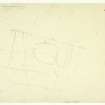
Prints and Drawings |
PBD 179/1 |
Records of the Royal Commission on the Ancient and Historical Monuments of Scotland (RCAHMS), Edinbu |
Publication Drawing: Scooped Homestead, Purvis Hill |
2/1963 |
Item Level |
|
|
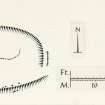
Prints and Drawings |
PBD 179/2 |
Records of the Royal Commission on the Ancient and Historical Monuments of Scotland (RCAHMS), Edinbu |
Plane-table Survey: Scooped Homestead, Purvis Hill. Shows cultivation terrace, rig and furrow and pipeline not on final plan. |
14/8/1961 |
Item Level |
|
|
Manuscripts |
MS 7251/1 |
General Collection |
Field notebook of Alastair MacLaren (RCAHMS). No.1: Peebleshire: clean copy. |
26/9/1956 |
Item Level |
|
 |
On-line Digital Images |
DP 278896 |
Records of the Royal Commission on the Ancient and Historical Monuments of Scotland (RCAHMS), Edinbu |
Publication Drawing: Scooped Homestead, Purvis Hill |
2/1963 |
Item Level |
|
 |
On-line Digital Images |
DP 278897 |
Records of the Royal Commission on the Ancient and Historical Monuments of Scotland (RCAHMS), Edinbu |
Plane-table Survey: Scooped Homestead, Purvis Hill. Shows cultivation terrace, rig and furrow and pipeline not on final plan. |
14/8/1961 |
Item Level |
|
 |
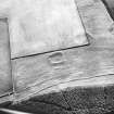
On-line Digital Images |
SC 1735111 |
RCAHMS Aerial Photography |
Oblique aerial view. |
1983 |
Item Level |
|
 |
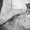
On-line Digital Images |
SC 1735112 |
RCAHMS Aerial Photography |
Oblique aerial view. |
1983 |
Item Level |
|
 |
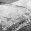
On-line Digital Images |
SC 1735113 |
RCAHMS Aerial Photography |
Oblique aerial view. |
1983 |
Item Level |
|
 |
On-line Digital Images |
SC 1735254 |
RCAHMS Aerial Photography |
Oblique aerial view. |
1983 |
Item Level |
|
 |
On-line Digital Images |
SC 1735256 |
RCAHMS Aerial Photography |
Oblique aerial view. |
1983 |
Item Level |
|
 |
On-line Digital Images |
SC 2444682 |
Records of the Ordnance Survey, Southampton, Hampshire, England |
Purvis Hill, NT33NE 1, Ordnance Survey index card, page number 1, Recto |
c. 1958 |
Item Level |
|
 |
On-line Digital Images |
SC 2444683 |
Records of the Ordnance Survey, Southampton, Hampshire, England |
Purvis Hill, NT33NE 1, Ordnance Survey index card, Verso |
c. 1958 |
Item Level |
|
 |
On-line Digital Images |
SC 2444684 |
Records of the Ordnance Survey, Southampton, Hampshire, England |
Purvis Hill, NT33NE 1, Ordnance Survey index card, Recto |
c. 1958 |
Item Level |
|
 |
On-line Digital Images |
SC 2444685 |
Records of the Ordnance Survey, Southampton, Hampshire, England |
Purvis Hill, NT33NE 1, Ordnance Survey index card, Recto |
c. 1958 |
Item Level |
|
|
All Other |
551 166/1/1 |
Records of the Ordnance Survey, Southampton, Hampshire, England |
Archaeological site card index ('495' cards) |
1947 |
Sub-Group Level |
|


