
Purvis Hill


Scooped Settlement (Middle Iron Age)
Site Name Purvis Hill
Classification Scooped Settlement (Middle Iron Age)
Canmore ID 53099
Site Number NT33NE 1
NGR NT 351 376
Datum OSGB36 - NGR
Permalink http://canmore.org.uk/site/53099


- Council Scottish Borders, The
- Parish Innerleithen
- Former Region Borders
- Former District Tweeddale
- Former County Peebles-shire
NT33NE 1 351 376.
(NT 3511 3763 and NT 3505 3760) Enclosures (NR)
OS 6" map (1964)
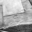
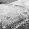
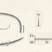
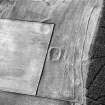
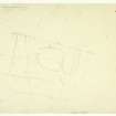
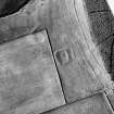
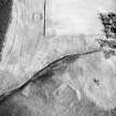
A scooped homestead, measuring 85' x 75' internally, is situated on the steep SW face of Purvis Hill. The enclosing wall has been largely obliterated, but a few facing stones still visible on the S side indicate that it was originally 9' thick. A gap on the ESE, 9' in width, marks the position of the entrance. Within the grassy interior, the level of which falls 10' N-S, there is a platform large enough for two timber houses.
RCAHMS 1967, visited 1961
The above, as described, was noted as an enclosure by the OS, who also noted, about 65m to the SW, the fragmentary remains of another enclosure, mutilated by the angle of a dry-stone dyke. It appears to have measured about 44.0m E-W by 28.0m. The small portion of the bank remaining on the W side of the wall is 5.0m wide and 1.0m high (externally). Only a very slight bank can be seen in the cultivated ground within the stone dyke.
Visited by OS (WDJ) 23 June 1961
The scooped homestead at NT 3611 3763 appears very prominently on the S slope of Purvis Hill and is generally as described. The enclosure is as described by the OS field surveyor (WDJ) and is now in very poor condition. Its date and purpose are uncertain.
Visited by OS (BS) 2 September 1974.
Sbc Note
Visibility: This is an upstanding earthwork or monument.
Information from Scottish Borders Council

