
Edinburgh, Holyrood Park, Arthur's Seat, The Dasses


Hut Circle(S) (Prehistoric)(Possible), Natural Feature(S) (Period Unknown), Quarry (Period Unknown)(Possible)
Site Name Edinburgh, Holyrood Park, Arthur's Seat, The Dasses
Classification Hut Circle(S) (Prehistoric)(Possible), Natural Feature(S) (Period Unknown), Quarry (Period Unknown)(Possible)
Alternative Name(s) Queen's Park
Canmore ID 52479
Site Number NT27SE 43
NGR NT 27472 73262
Datum OSGB36 - NGR
Permalink http://canmore.org.uk/site/52479


- Council Edinburgh, City Of
- Parish Edinburgh (Edinburgh, City Of)
- Former Region Lothian
- Former District City Of Edinburgh
- Former County Midlothian
NT27SE 43 centred 2745 7325.
(Centred NT 2745 7325) Hut Circles (NR)
OS 25" map, (1968)
There is a row of six hut circles, varying in diameter from 16'-25', and occupying a space just under 50 yards in length, on the second highest of the Dasses.
Stevenson (1949) also notes another hut circle, 25'-30' in diameter, at the head of the lowest of the Dasses.
R B K Stevenson 1949; RCAHMS 1951.
A row of six hut circles with annexes, generally as described in previous information. The hut noted by Stevenson could not be located.
Visited by OS (S F S) 8 December 1975.
Publication Account (1951)
209. Hut-Circles, King's Park.
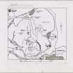
A row of six hut-circles, varying in size from 16 ft. to 23 ft.in diameter, and occupying a space just under 50 yds. in length, is situated on the second highest of the Dasses (Fig. 429C [DP 149972]) which forms a little valley above the Hunter's Bog. The lower end of the valley is closed by a stone-faced bank through which water from a spring runs away. The hut-circles have been fully described by Mr. R. B. K. Stevenson (1), who considers them to be the earliest monument in the King's Park.
RCAHMS 1951, visited c.1941
(1) P.S.A.S., lxxxi (1946-7), p. 170.
OS Map Midlothian iii N.E. (unnoted).
Condition Survey (February 1996)
The remains of these hut circles were extremely indistinct and consisted of a number of stones located in long grass, within which with the eye of faith a number of circles were visible.
Information from Derek ALexander (Centre for Field Archaeology) 1997, no.12
Field Visit (15 December 1998)
There is nothing to suggest the presence of a row of six hut-circles at this location. All that can now be seen are scatters of tumbled stones and boulders, some of which are earthfast.
Visited by RCAHMS (ARG), 15 December 1998
NMRS, MS/726/96 (37-8, no. 12); RCAHMS 1999.
Watching Brief (22 September 2008 - 26 September 2008)
NT 274 732 (centred on) A series of watching briefs was maintained, 22–26 September 2008, during the excavation of small trenches at various locations around Holyrood Park. This work was to allow the installation of 13 orientation signs inside the entrances to the park. Where possible the signs were wall-mounted or fixed to railings or gates. However, seven of the signs required trenches to be dug for concrete bases. The seven trenches measured a uniform 1.35m x 0.6m and were 0.4m deep and were located as follows – (1) NT 2676 7360, (2) NT 2701 7371, (3) NT 2771 7401, (4) NT 2654 7334, (5) NT 2657 7292, (6) NT 2695 7272 and (7) NT 2825
7268.
The deposits encountered were predominantly modern, showing much recent disturbance or landscaping, although in some places there were undisturbed horizons, possibly 18th-century.
Archive: RCAHMS (intended)
Funder: Historic Scotland
Alan Radley (Kirkdale Archaeology), 2008
Condition Survey (12 March 2018 - 15 April 2018)
The CFA Archaeology Condition Survey of 2018 found a number of very shallow, (0.05m-0.1m) discrete depressions. These were very close together and may be the result of quarrying rather than hut circles. The area is covered in thick grass and no sign of the protruding stones were observed.
Information from Graeme Carruthers (CFA Archaeology Ltd) July 2018. OASIS ID: cfaarcha1-317194, no.12

