
Edinburgh, Holyrood Park, Arthur's Seat, The Dasses


Enclosure(S) (Period Unassigned)(Possible)
Site Name Edinburgh, Holyrood Park, Arthur's Seat, The Dasses
Classification Enclosure(S) (Period Unassigned)(Possible)
Alternative Name(s) Queen's Park
Canmore ID 52476
Site Number NT27SE 427
NGR NT 27434 73415
Datum OSGB36 - NGR
Permalink http://canmore.org.uk/site/52476


- Council Edinburgh, City Of
- Parish Edinburgh (Edinburgh, City Of)
- Former Region Lothian
- Former District City Of Edinburgh
- Former County Midlothian
NT27SE 427 2743 7341
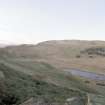
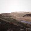
On the third highest of the escarpments known as The Dasses, there is a rectangular enclosure whose stony outline, originally 3ft (0.9m) thick, is about 70ft by 80ft (21.3 by 24.4m). At the upper end, a cross-bank cuts off a 12ft (3.7m) wide space which seems to have been levelled artificially. This suggests a long cottage, and byre, at the head of its yard. Not far to the SW, at the foot of the crag, is a larger enclosure, 120ft by 140ft (36.6 by 42.7m), of similar construction. There is no suggestion here of a dwelling.
R B K Stevenson 1949.
Condition Survey (February 1996)
Survey did not locate any remains of this possible farmstead, perhaps thick grass cover and gradual denuding of the features, since 1949, have removed any visible traces.
Information from Derek Alexander (Centre for Field Archaeology, University of Edinburgh) February 1997, no.46
Alexander 1997
Field Visit (15 December 1998)
(Location formerly cited as NT 274 733: amended to NT 2743 7341). There is little to suggest the presence of a farmstead at this location. The ground is very broken and strewn with boulders, and all that can now be seen are the grass-grown footings of an L-shaped stretch of wall at the foot of rock outcrop. This wall is plotted at 1:5,550 on an archaeological map of Holyrood Park (RCAHMS 1999).
Visited by RCAHMS (ARG), 15 December 1998.
NMRS, MS/726/96 (58-9, no. 46); RCAHMS 1999.
Condition Survey (12 March 2018 - 15 April 2108)
The 2018 CFA Archaeology Ltd condition survey found that the site is visible in the thick vegetation as a discrete sub-rectangular series of banks/walls 0.2m high. The feature has three sides with the western side formed by the edge of a sheer cliff. There are two parallel bank/walls on the southern side.
Information from Graeme Carruthers (CFA Archaeology Ltd) July 2018. OASIS ID: cfaarcha1-317194, no.46
Alexander 1997

