
Pricing Change
New pricing for orders of material from this site will come into place shortly. Charges for supply of digital images, digitisation on demand, prints and licensing will be altered.
Caiy Stane


Cup Marked Stone (Neolithic) - (Bronze Age), Graffiti (19th Century), Standing Stone (Neolithic) - (Bronze Age), Standing Stone (Prehistoric)
Site Name Caiy Stane
Classification Cup Marked Stone (Neolithic) - (Bronze Age), Graffiti (19th Century), Standing Stone (Neolithic) - (Bronze Age), Standing Stone (Prehistoric)
Alternative Name(s) Caiystane; Cetstane; Kel Stane; Camus Stone;
Canmore ID 51756
Site Number NT26NW 14
NGR NT 24243 68357
Datum OSGB36 - NGR
Permalink http://canmore.org.uk/site/51756


- Council Edinburgh, City Of
- Parish Edinburgh (Edinburgh, City Of)
- Former Region Lothian
- Former District City Of Edinburgh
- Former County Midlothian
NT26NW 14 2424 6835
See also NT26NW 13.
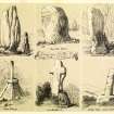
The Caiy Stane, also called the Kel Stane or Camus Stone (OSA 1797) (but cf. NT26NW 26), is situated in a recess in the wall on the E side of Caiystane View, near the junction with Oxgangs Road. It is a fine monolith of red sandstone, roughly rectangular in section, facing E-W. It measures 9ft 3ins (2.75m) in height, from 4ft 2ins (1.23m) to 5ft 9ins (1.55m) in breadth and from 10ins (0.25m) to 1ft 7ins (0.48m) in thickness. A row of six much-weathered cup-marks may be seen low down on its E face.
T Whyte 1792; J Y Simpson 1866; F R Coles 1903; RCAHMS 1929; R W Feachem 1977.
Field Visit (28 August 1913)
Caiy Stone, Fairmilehead.
About ¼ mile west of Fairmilehead, in a cultivated field on the northern side of the road to Colinton, is a fine monolith of red sandstone, roughly rectangular in shape. It stands on the summit of a small rise 54 feet north of the road-side and 80 feet west of a belt of trees. It is 9 feet 3 inches in height, 5 feet 9 inches in breadth about half way up its height, 4 feet 2 inches at the base, and 19 inches in thickness on the southern side and 10 inches on the northern side. It faces almost due east and west. Some 14 inches from the ground on the eastern face is a curved row of six small hollows, varying from 7/8 inch to 2 inches in diameter, the smallest being towards the southern edge of the stone and 20 inches from it. These hollows, although much weathered, appear to be artificial and have been recorded as cup marks by Sir James Y. Simpson (1). The stone hasb een known also as the Kel Stane or the Camus Stone (2).
RCAHMS 1929, visited 28 August 1913.
(1) Proc. Soc. Ant. Scat., vi (1864-5), p. 32; (2) Cf. Statistical Account (1797), xix, p. 591; Proc. Soc. Ant. Scat., xxxvii (1902-3), p. 208.
Project (1997)
The Public Monuments and Sculpture Association (http://www.pmsa.org.uk/) set up a National Recording Project in 1997 with the aim of making a survey of public monuments and sculpture in Britain ranging from medieval monuments to the most contemporary works. Information from the Edinburgh project was added to the RCAHMS database in October 2010 and again in 2012.
The PMSA (Public Monuments and Sculpture Association) Edinburgh Sculpture Project has been supported by Eastern Photocolour, Edinburgh College of Art, the Edinburgh World Heritage Trust, Historic Scotland, the Hope Scott Trust, The Old Edinburgh Club, the Pilgrim Trust, the RCAHMS, and the Scottish Archive Network.
Field Visit (26 February 2000)
Standing stone with cup-marks 50cm from the ground on the east face, standing in a semi-circular cobbled area with a wall behind.
Inscriptions : None
Signatures : None
Information from Public Monuments and Sculpture Association (PMSA Work Ref : EDIN0340)
Field Visit (10 October 2019)
A signature 'J FORREST' has been incised into the rear face of this standing stone. The style of the lettering suggests that the graffiti is of 19th or early 20th century date.
Visited by HES Survey and Recording (JRS) 10 October 2019.
Note (14 December 2020)
Date Fieldwork Started: 14/12/2020
Compiled by: ScRAP
Location Notes: The standing stone is located as described in the Canmore record. It stands in a walled niche at the side of a residential street named Caiystane View – one of 9 streets in the vicinity named Caiystane – but it would once have stood on an open hillside as part of a wider complex. Around 230m E of the Caiy Stane were a pair of large cairns known as the Cat Stanes. A second standing stone known as the Camus Stone (now gone) stood a further 250m E of the Cat Stanes, and in the surrounding area hundreds of skeletons were found during road-building in the early 19th century.
Panel Notes: This red sandstone standing stone is roughly rectangular, measuring 2.7m high with a pointed, segmented tip, and maximum width of 1.25m, narrowing at the base. It is 0.48-0.25m thick, and the wider surfaces face E and W. The W surface, facing into Caiystane View, is rough and undulating with wide weathering channels running from the top of the stone to about half the way down its height. This surface is pitted with small circular depressions and larger sub-circular depressions of varying sizes. There are also sub-circular depressions on the thinner S surface. The northern edge of the W face features several thin parallel incisions which extend round onto the thinner N surface. The E surface, which faces the back of the recess, is much smoother and flatter, suggesting that this was the original quarried surface whereas the W face originally formed the exposed surface of outcrop. The E face features several eroding bedding planes, narrow fissures, and numerous small pitted depressions, as well as several inscribed names and initials. Additionally, the E surface has groups of larger circular and sub-circular depressions on its lower half. These include and arc of 4 depressions near the centre of the E surface, and undulating alignment of size depressions of increasing size towards the base of the stone, and a rosette-like group of 7 small depressions. The arrangement of these depressions suggest some may be cupmarks, although most have uneven and asymmetric profiles that is more fitting with natural features. It is possible that the depressions were created on the quarried surface when the stone was erected, but have since eroded differentially through millennia of exposure to wind and weather.
Additional Description: Bibliographic Ref: Title : The Buildings of Scotland : Edinburgh, Author(s) : J.Gifford, C.McWilliam, D.Walker and C.Wilson, Publisher : Penguin Books Ltd, Edition : 1991, Titleaddit : J.Gifford, C.McWilliam, D.Walker and C.Wilson, The Buildings of Scotland : Edinburgh, Page No.s : p.566
Bibliographic Ref: Title : Historic South Edinburgh, Author(s) : Charles J. Smith, Publisher : Charles Skilton Ltd, Volume : Vol. 2, Place : Edinburgh, Year : 1979, Titleaddit : Charles J. Smith, Historic South Edinburgh, Page No.s : pp.400-401
NT26NW 14 2424 6835
See also NT26NW 13.
The Caiy Stane, also called the Kel Stane or Camus Stone (OSA 1797) (but cf. NT26NW 26), is situated in a recess in the wall on the E side of Caiystane View, near the junction with Oxgangs Road. It is a fine monolith of red sandstone, roughly rectangular in section, facing E-W. It measures 9ft 3ins (2.75m) in height, from 4ft 2ins (1.23m) to 5ft 9ins (1.55m) in breadth and from 10ins (0.25m) to 1ft 7ins (0.48m) in thickness. A row of six much-weathered cup-marks may be seen low down on its E face.
T Whyte 1792; J Y Simpson 1866; F R Coles 1903; RCAHMS 1929; R W Feachem 1977.
The Public Monuments and Sculpture Association (http://www.pmsa.org.uk/) set up a National Recording Project in 1997 with the aim of making a survey of public monuments and sculpture in Britain ranging from medieval monuments to the most contemporary works. Information from the Edinburgh project was added to the RCAHMS database in October 2010 and again in 2012.
The PMSA (Public Monuments and Sculpture Association) Edinburgh Sculpture Project has been supported by Eastern Photocolour, Edinburgh College of Art, the Edinburgh World Heritage Trust, Historic Scotland, the Hope Scott Trust, The Old Edinburgh Club, the Pilgrim Trust, the RCAHMS, and the Scottish Archive Network.
Standing stone with cup-marks 50cm from the ground on the east face, standing in a semi-circular cobbled area with a wall behind.
Inscriptions : None
Signatures : None
Information from Public Monuments and Sculpture Association (PMSA Work Ref : EDIN0340)
A signature 'J FORREST' has been incised into the rear face of this standing stone. The style of the lettering suggests that the graffiti is of 19th or early 20th century date.
Visited by HES Survey and Recording (JRS) 10 October 2019.
This project indicates that the record to which it is linked is within, or near the boundary, of an area managed by a SURE partner.
Information from RCAHMS (SC) 18 October 2011

