
Aberdour Castle


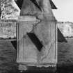
Castle (Medieval), Sundial (Period Unassigned)
Site Name Aberdour Castle
Classification Castle (Medieval), Sundial (Period Unassigned)
Canmore ID 50844
Site Number NT18NE 8
NGR NT 19239 85469
Datum OSGB36 - NGR
Permalink http://canmore.org.uk/site/50844


First 100 images shown. See the Collections panel (below) for a link to all digital images.
- Council Fife
- Parish Aberdour (Dunfermline)
- Former Region Fife
- Former District Dunfermline
- Former County Fife
NT18NE 8.00 19239 85469
NT18NE 8.01 19307 85400 Dovecot
NT18NE 8.02 192 854 Garden
NT18NE 8.03 1904 8565 Garden
NT18NE 8.04 19109 85369 West Gateway
NT18NE 8.05 19323 85518 Walled Garden
(NT 1924 8547) Aberdour Castle (NR)
OS 6" map (1966)
Aberdour Castle, which is under guardianship, is fully described in the attached guide. The remains are in an excellent state of preservation.
M R Apted 1966
Visited by OS (AC) 11 March 1959
No change to previous information.
Visited by OS (BS) 17 December 1975
A broken semicircular enamelled copper alloy ornament was discovered during MoW excavations in the 1950's.
C Bourke and J Close-Brooks 1990
NT 1924 8547. The excavation of inspection pits in advance of wall stabilising measures was monitored by Kirkdale Archaeology on the N terraces of the 16th and 17th-century garden layout. The terraces comprised massive dumps of humic earth, with evidence for the method of terrace construction in the form of tip lines, suggesting that the terraces and their retaining walls were raised concurrently. A further trench was excavated on the S side of the doocot, where evidence for modern stabilising measures was revealed, in the form of a massive concrete support around the base of the wall.
Sponsor: Historic Scotland
G Ewart and A Dunn, 1996
NT 1924 8547 A short programme of excavation was carried out during early 1999 on the terraces situated against the S side of Aberdour Castle. Detailed evidence was recorded of the sequence of alterations to the terraces and 16th-century terrace walls, and various garden features were also encountered.
A fuller summary has been lodged with the NMRS.
Sponsor: Historic Scotland.
D Stewart 1999.
NT 1924 8547 An evaluation in May 2003 comprised the excavation of a series of test pits to assess the impact of planting a protective hedge line on one of the terraces in the gardens. This terrace, the second terrace down from the castle on the N side of the gardens, is one of the last survivors of the original arrangement of seven terraces around the N and W sides of the area to the N of the castle. It was shown that excavation up to 500mm was unlikely to disturb significant archaeological remains.
Archive to be deposited in the NMRS.
Sponsor: HS
G Ewart 2003
NMRS REFERENCES
Architect: Master James Smith 1690 - estimate of works to be carried out.
(From reference given in Topographical catalogue)
ABERDOUR CASTLE
Typescript of research files prepared by Dr M R Apted while the author was an Inspector of Ancient Monuments ( Scotland). Presented by Dr Michael R Apted.
EXTERNAL REFERENCES
NATIONAL LIBRARY OF SCOTLAND
Sketches of Scottish Scenery No. 25.1
SCOTTISH RECORD OFFICE
Morton Papers (Dalmahoy Collection) Box 117 - Aberdour Accounts 1657-1797
Slaterwork undertaken by James Gib about the Castle of Aberdour. It includes pointing the North side of the Gallery adn the woman house, the two ends of the brewhouse and parts of the washing house.
Receipted account.
1672
GD150/2390/2
Estimate of the expense of taking down Aberdour Castle to the West of the Gallery, the woman house and the Inner court wall. It amounts to ?1144.00 (Scots)
The Earl of Morton is to furnish tools and materials.
ND
GD150/2390/3
Payments for deals and slates for Castle and House. (1682-1689). Noted in James Hay's Account of the Earl of Morton's Money'.
Notebook.
1681-1696
GD150/2401/1
Repairs to (?Aberdour Castle).
Letter from Hugh Abercrombie (Chamberlain) to James hay. W S.
Mr Abercrombie has spoken to certain tenants to bring in lime. The repairs are necessary so that furnishings will not be spoiled.
April 14
1682
GD150/2405/53
Repair of the roof of the Castle.
The Slater and Wright have been consulted. Chrystie suggests that the timber of the old hosue may serve to repair it unless Master Robert Douglas prefers to order new.
ND (?1709)
GD150/2406/8
Payment of 3 guineas 'to Master James Smith, mason, for going to Aberdour and his measuring and surveying the house and drawing some draughts of a new house with a particular note of what the charge might be and for his other pains in that affair'. 1690.
James Hay's 'Account of the earl of Morton's Money'.
Notebook.
1681-1696
GD150/2410/1 Page 37
Estimate of work to be carried out on the old part of the House of Aberdour. It includes flagging of 40 doors and windows and rebuilding them in proper places and work on outer stair, the pavement walk and the cornice going round the front otthe house.
1690
GD150/2410/18
Estimate of the reparations to be made at the House of Aberdour. It includes flagging of 40 doors and windows and rebuilding them in proper places and work on outer stair, the pavement walk and the cornice going round the front ot the house.
1690
GD150/2410/18
Estimate of the reparations to be made at the House of ABerdour. It includes an addition to the house and improvements to the existing building. The cost is estamated at ?1210 16 4.
Unsigned.
1690
GD150/2410/18
(Some details follow)
(Cross ref GD150/2410/1 Page 31)
Addition to the House of Aberdour. Estimate of the cost, of digging the foundation, of stone for the Back Stairs and Great Stair, and of hewn work for the 17 door and windws on each storey.
1690
GD150/2410/18
Estimate of the alterations to be made at the House of Aberdour 'The whole length of the gallery to continue, the new adition to be made to the North side of its 28 ells long and the Wester gable is 6 2/3 and the Easter gable 6 2/3 and the great staircase 22 1/3 ells about and the small staricase and buttery 7 1/3 ells wich being accumulate in one the new addition is in the circumference 71 ells and multiplied by 11 which is the height is 781 ells'.
Total expense of estimate ?130.3.4
1690
GD150/2410/18
Repair of the Castle of Aberdour.
Account of money paid for slater and wright work.
?192.18.10
1682
GD150/2420/14
Wright work at the Castle of Aberdour.
Account from Thomas Livingston, wright. It includes a sum for working in the gallery.
1671
GD150/2448/26
Slater work at the Castle of Aberdour.
Receipted account from James Gib Slater in Burntisland for 'painting the gallery and chamber square'.
1675
GD150/2448/39
Smith work at the Castle of Aberdour.
Account form a chimney of 6 stone 6 pounds in weight, new locks and keys and various items of iron work.
1675
GD150/2448/40
mason, Wright and Slater work.
The work includes the quarrying of stone for the gates and the removal of the storm window in the gallery.
William Green's account book.
1741
GD150/2737/4/Page 29
Receipt from Robert Bennet, Wright at Whitehill for work in the gallery 'making things for observing the eclipse'.
1748
GD150/2483/1/30
The burning of the Earl of Morton's House of Aberdour. Army officers were lodged there and their servants had put on large fires after washing the rooms. At 5 a.m. fire broke out with great violence in teh room above the Dining room and all the apartments between the gallery and the castle were gutted. the Gallery was saved by building up the door to the Dining room with stone. Most of the paintings were destroyed.
'This accident must now push your lordship to build a new house'.
Letter. Robert Douglas to the Earl of Morton.
1701 (Cross ref. 1713 GD150/3460/18-19x)
GD150/3458/8
The burning of the House of Aberdour. Casued by the carelessness of the servants of the officers billeted there 'most of my old fyne valuable pictures, all the furniture I had and worst of all one of my ancient charters and papers' were lost. The Earl of Morton hopes that the Queen will take his 'deplorable condition under her Royal consideration'. Letter from James 10th Earl of Morton. consideration'. Letter from James 10th Earl of Morton.
1713 (Cross ref GD150/3458/8 1701)
GD1503460/18-19x
'Surely sooner or later Aberdour will be rebuilt unless some other house fit for the family both for size and situation fall in my lord's way'.
Letter from John Drummond to Lord Aberdour.
1731
GD150/3474/9
Field Visit (19 July 1928)
Aberdour Castle.
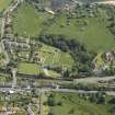
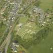
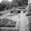
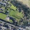
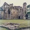
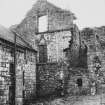
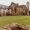
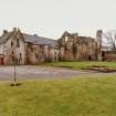
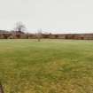
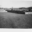
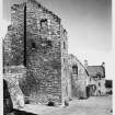
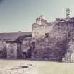
The castle stands on a plateau on the left bank of the Dour Burn overlooking the harbour. The site is on the same level as the neighbouring ground on the east, but in other directions there is a more or less rapid descent, the south side in particular being protected by a ravine formed by the burn. Its western end is occupied by a connected series of buildings, for the most part ruinous and incomplete, which may be dated to various periods from the 14th to the 17th century. Expansion to the east has been restricted by the church and its graveyard. The earliest stage is represented by the ruinous tower at the north-west, which has been a self-contained house of probably the 14th century, but which was altered in the second half of the 15th century and supplemented by an outbuilding. In the late 16th century the latter part was almost entirely destroyed and its remains were included in the western part of the present south range, the whole being linked to the old tower by a spacious turnpike-tower while a new range of offices was constructed at some distance west of the old tower. In the early 17th century a third range, which included a long gallery on the upper floor, was run out eastwards from the south-east corner of the south range. Contemporaneously with the building of the last addition, an extensive walled garden was laid out on the eastern side of the castle and to the north of the church, for in that direction alone was there ground available. The eastern entrance to the garden bears in the pediment an Earl's coronet and the date 1632 with a cartouche, on which are represented in monogram the initials of William, seventh Earl of Morton, and his Countess, Lady Anne Keith.
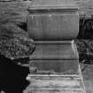
On the south of the castle a broad terrace, enclosed by a parapet wall with moulded cope, runs east and west. At its eastern end a doorway, in the pediment of which is a cartouche bearing the Douglas heart, opens into the churchyard, and a flight of steps descends to a lower terrace. At this lower level a broader terrace runs southward, which was the "bowling green" referred to in Kirk's Tour of 1677.
[See RCAHMS 1933 p. 17-21 for an architectural description and historical note]
RCAHMS 1933, visited 19 July 1928.
Aerial Photography (1966)
Oblique aerial photographs of Aberdour, FIfe, photographed by John Dewar in 1966.
Aerial Photography (1966)
Oblique aerial photographs of Aberdour, Fife, photographed by John Dewar in 1966.
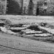
Excavation (1977)
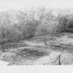
NT 192854 Excavations were begun in advance of a garden restoration
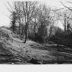
scheme. The work concentrated on the N-S terraces of the garden to the S of the castle. The foundations of three terrace walls were revealed along with those parts of the terrace-walks surviving from the market garden phase. Traces of the stair-cases at the N end of each terrace were discovered and found to be alternately N-S and E-W aligned. The S ends of the upper two terraces were flanked by cross-walls. A series of drains and soak-aways were an integral part of the terrace construction.
G J Ewart 1977
Kirkdale Archaeology
Excavation (1978)
NT 192854 Excavation took plate in advance of masonry consolidation and restoration on the garden terraces to the S of the castle. The foundations of the terrace retaining-walls were excavated and the overall layout of the garden, established in the 16th century and dismantled in the early 1700's lias been obtained.
Sponsor: SDD (AM)
G Ewart 1978
Kirkdale Archaeology
Excavation (31 March 1980 - 25 April 1980)
NT 192854 This season saw the completion of excavation at the W end of the N terraces together with an investigation of two features within the general garden complex, a covered drain and the mill lade. The drain was well constructed and ran S, probably from the castle kitchens, down through the N terraces. The mill lade was found to be a narrow channel running from the Dour burn in the NW of the site and across the orchard area of the garden to a mill pond.
G J Ewart
Sponsor: SDD (AM)
Kirkdale Archaeology
Excavation (1981)
Excavations were undertaken by Kirdale Archaeology on the lower terraces of Aberdour castle by the Doo'cot.
Kirkdale Archaeology
Publication Account (1987)
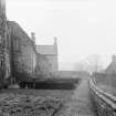
Aberdour Castle presents a complex of buildings and gardens representing four distinct building periods dating from about the 13th century to the 17th century. This complex has been constructed on the site of an earlier castle which formed the capital messuage of the Barony of Aberdour granted by Robert Bruce to his nephew, Thomas Randolph, Earl of Moray, about 1325. The Morays granted a charter of the barony to William Douglas, Knight, in 1342 and the property has remained in the possession of successive branches of the Douglas family ever since. In 1386 the baronies of Aberdour and Dalkeith were united into a single barony of regality known as the Regality of Dalkeith, an arrangement which lasted until 1642.
The site of the castle was originally one of considerable strength but this has been diminished at various times. The construction of the garden terraces to the south of the castle in the 17th century and the construction of the railway embankment on the north side in the 19th century were the two most influential factors in changing the site. Various other alterations have taken place over the years to make the building more domestic in character, particularly the reduction of the inner courtyard wall to its foundations. When viewed as a whole the castle expresses this long process of alteration and expansion.
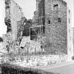
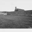
The oldest part of the castle is the tower which forms the west range of the present layout. The plan-form of this tower is a parallelogram measuring approximately 16m by 11m overall. The walls are finished with flat clasped buttresses at the north and east corners. The foundation is stepped except for part of the south-east wall which is built on a splayed base course. The walls are 1.8m thick. These remains and some internal fragments suggest that this formed an exceptionally early free-standing tower-house. The angle buttresses, splayed base course and cubical masonry are characteristric of 12th century structures and the double lancet window at fIrst-floor level is typical of 13th century work.
Rebuilding of the upper part of the tower probably took place in the 15th century. The accommodation provided in the reconstructed tower, although adequate when built, was less than adequate for the requirements of a 16th century laird's household and a new range was added to the south-east This forms the central range of the present layout and is roughly rectangular on plan with a projecting stair at the south corner. The new building is linked to the old by a stair which serves them both at all principal levels. Internally the accommodation comprises two rooms per floor connected by a passage along the north side.
On the ground floor the vaulted kitchen contains a large arched fIreplace into which an oven was inserted in 1674. East and west of the castle are courtyards which were added in the 16th century but which may reflect an earlier layout repeated on a larger scale. In the west courtyard is a range of outbuildings built against the courtyard walL including a brewery and bakehouse with two large ovens. The east courtyard contains a well house which may also have served as a laundry.
The existing east range was added to the north-east of the 16th century building by Earl William Morton who succeeded to the title in 1606 and died in 1648. This extension is L-shaped on plan with a projecting wing at the south corner and the principal stair in the re-entrant angle. One of the two small towers projecting from the north front is original, the other an early addition. The whole of the first floor of this range formed a picture gallery and it is possible that the ceilings were painted in tempera, as was popular in Scotland in the early 17th century. Certainly the entresol has such a ceiling. The walls were panelled in timber.
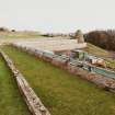
The gardens are situated to the east and south of the castle. The east walled garden encloses half a hectare within walls 3.7m high in characteristic 17th century style, with enriched pediments on the two gateways, one with the Douglas heart and the other with the date 1632 and the monogram ofWilliam, Earl of Morton and his wife Countess Anne. The courtyard gate was inserted in 1740. The garden also contained a summer house and bridge to the kitchen garden but only slight evidence of these features survives.
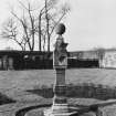
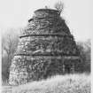
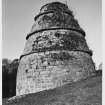
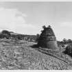
To the south of the castle are two terraces, all that remain of the four terraces existing in 1745. Beyond them is a large beehive-shaped dovecote containing about 600 nests and the remains of a potence. Beyond the dovecote was the orchard or 'wilderness' situated on land that was drained and laid out in 1690.
Information from ‘Exploring Scotland’s Heritage: Fife and Tayside’, (1987).
Excavation (7 October 1996)
NT 1924 8547. The excavation of inspection pits in advance of wall stabilising measures was monitored by Kirkdale Archaeology on the N terraces of the 16th and 17th-century garden layout. The terraces comprised massive dumps of humic earth, with evidence for the method of terrace construction in the form of tip lines, suggesting that the terraces and their retaining walls were raised concurrently. A further trench was excavated on the S side of the doocot, where evidence for modern stabilising measures was revealed, in the form of a massive concrete support around the base of the wall.
G Ewart and A Dunn 1996
Sponsor: Historic Scotland
Kirkdale Archaeology
Excavation (9 February 1999 - 3 March 1999)
NT 1924 8547 A short programme of excavation was carried out during early 1999 on the terraces situated against the S side of Aberdour Castle. Detailed evidence was recorded of the sequence of alterations to the terraces and 16th-century terrace walls, and various garden features were also encountered.
D Stewart 1999
Sponsor: Historic Scotland
Kirkdale Archaeology
Excavation (3 October 2002 - 8 October 2002)
Under the terms of its P.I.C. call-out contract with Historic Scotland, Kirkdale Archaeology was asked to undertake an archaeological evaluation at Aberdour Castle. This comprised the excavation of a series of investigative test pits to assess the archaeological potential which might be disturbed by the planting of a protective hedge line on one of the terraces in the gardens.
The site of the work would be the second terrace down from the castle on the N side of the gardens (Fig. 1). This terrace is one of the last survivors of the original arrangement of 7 terraces around the N and W sides of the area to the N of the castle main structure. This terrace is notable for the precarious nature of the revetting wall along the S edge of the feature, which leans out to the S at an alarming angle. The wall of rough whinstone blocks has now been made safe by the construction of 12 buttresses. The parapet wall running along the top of the main revetment is a partly derelict sandstone structure which only requires its original cope stones to be complete but which for the moment will be consolidated in its present state.
The intention is to plant a hedge along the S edge of the terrace just inside the line of the parapet wall.
The 3 test pits spaced along the terrace were dug to establish whether the projected depth of the roots (600mm) will damage original garden features - in particular layouts of ornamental flower beds now buried below later levels of soil believed to have been imported to create a market garden.
It is clear that little damage will be caused down to a depth of 500mm. At this point the superficial deposits change into terrace surface. It is noted that depressions along the central part of the terrace against the wall may represent a long investigative trench cut to halt the lean on the wall. It is also noted that the far end of the terrace has been levelled up on the 1980s to take account of the rebuilding of the E end of the terrace revetment.
G Ewart 2002
Sponsor: Historic Scotland
Kirkdale Archaeology
Watching Brief (7 September 2011)
NT 1910 8537 and NT 1923 8545 A watching brief was carried out on 7 September 2011 during the excavation of two small trenches in advance of the installation of new signs at Aberdour Castle. The first, near the entrance gate (NT 1910 8537), revealed whin dust, suggesting recently laid turf. The second, just SW of the Castle (NT 1923 8545), was on the site of an existing display board, but a mortar-rich layer at the lower limit of excavation may represent an undisturbed horizon.
Archive: RCAHMS (intended)
Funder: Historic Scotland
Kirkdale Archaeology, 2011
Information also reported in Oasis (kirkdale1-122345) 26 March 2013

