Field Visit


Date 19 July 1928
Event ID 1098212
Category Recording
Type Field Visit
Permalink http://canmore.org.uk/event/1098212
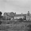
Aberdour Castle.
The castle stands on a plateau on the left bank of the Dour Burn overlooking the harbour. The site is on the same level as the neighbouring ground on the east, but in other directions there is a more or less rapid descent, the south side in particular being protected by a ravine formed by the burn. Its western end is occupied by a connected series of buildings, for the most part ruinous and incomplete, which may be dated to various periods from the 14th to the 17th century. Expansion to the east has been restricted by the church and its graveyard. The earliest stage is represented by the ruinous tower at the north-west, which has been a self-contained house of probably the 14th century, but which was altered in the second half of the 15th century and supplemented by an outbuilding. In the late 16th century the latter part was almost entirely destroyed and its remains were included in the western part of the present south range, the whole being linked to the old tower by a spacious turnpike-tower while a new range of offices was constructed at some distance west of the old tower. In the early 17th century a third range, which included a long gallery on the upper floor, was run out eastwards from the south-east corner of the south range. Contemporaneously with the building of the last addition, an extensive walled garden was laid out on the eastern side of the castle and to the north of the church, for in that direction alone was there ground available. The eastern entrance to the garden bears in the pediment an Earl's coronet and the date 1632 with a cartouche, on which are represented in monogram the initials of William, seventh Earl of Morton, and his Countess, Lady Anne Keith.
On the south of the castle a broad terrace, enclosed by a parapet wall with moulded cope, runs east and west. At its eastern end a doorway, in the pediment of which is a cartouche bearing the Douglas heart, opens into the churchyard, and a flight of steps descends to a lower terrace. At this lower level a broader terrace runs southward, which was the "bowling green" referred to in Kirk's Tour of 1677.
[See RCAHMS 1933 p. 17-21 for an architectural description and historical note]
RCAHMS 1933, visited 19 July 1928.