
Pricing Change
New pricing for orders of material from this site will come into place shortly. Charges for supply of digital images, digitisation on demand, prints and licensing will be altered.
Upcoming Maintenance
Please be advised that this website will undergo scheduled maintenance on the following dates:
Thursday, 9 January: 11:00 AM - 3:00 PM
Thursday, 23 January: 11:00 AM - 3:00 PM
Thursday, 30 January: 11:00 AM - 3:00 PM
During these times, some functionality such as image purchasing may be temporarily unavailable. We apologise for any inconvenience this may cause.
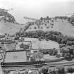
Aberdour Harbour


Harbour (18th Century)
Site Name Aberdour Harbour
Classification Harbour (18th Century)
Alternative Name(s) Dour Burn
Canmore ID 50835
Site Number NT18NE 39
NGR NT 19472 85100
Datum OSGB36 - NGR
Permalink http://canmore.org.uk/site/50835


- Council Fife
- Parish Aberdour (Dunfermline)
- Former Region Fife
- Former District Dunfermline
- Former County Fife
NT18NE 39 1950 8515.
(Location cited as NT 194 851). Aberdour Harbour, early 18th century and later. A natural harbour protected by an irregular pier built of coursed and uncoursed rubble.
J R Hume 1976.
This harbour is situated at the mouth of the Dour Burn. It dries at low water and is used almost exclusively by recreational and pleasure craft, notably those of the Aberdour Sailing Club whose boathouse is situated at the base of the pier.
Information from RCAHMS (RJCM), 8 July 1998.
Harbour. Drystane, large beach cobbles. Silted up.
Site recorded by Maritime Fife during the Coastal Assessment Survey for Historic Scotland, Kincardine to Fife Ness 1996
Aerial Photography (1966)
Oblique aerial photographs of Aberdour, FIfe, photographed by John Dewar in 1966.

