
Pricing Change
New pricing for orders of material from this site will come into place shortly. Charges for supply of digital images, digitisation on demand, prints and licensing will be altered.
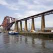
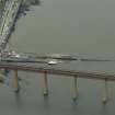
South Queensferry, Hawes Pier


Pier (19th Century), Slipway (19th Century)
Site Name South Queensferry, Hawes Pier
Classification Pier (19th Century), Slipway (19th Century)
Alternative Name(s) South Queensferry, Old Ferry Pier; Ferry Slip; Newhalls Road; Inner Forth Estuary; Upper Firth Of Forth; Queensferry Narrows
Canmore ID 50550
Site Number NT17NW 172
NGR NT 13633 78497
Datum OSGB36 - NGR
Permalink http://canmore.org.uk/site/50550


- Council Edinburgh, City Of
- Parish Dalmeny
- Former Region Lothian
- Former District City Of Edinburgh
- Former County West Lothian
NT17NW 172.00 13633 78497
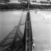
See also NT17NW 70 Forth Railway Bridge.
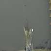
NT17NW 172.01 NT 13585 78649 Beacon ('Lighthouse')
NT17NW 172.02 NT 13683 78386 Lifeboat Station (Inshore rescue boat)
Not to be confused with South Queensferry Harbour (NT 13017 78545), for which see NT17NW 71.00.
For corresponding Town ('Ferry') Pier at North Queensferry, Fife (NT 13096 80274), see NT18SW 112.00.
Hawes Pier [NAT]
OS 1:10,000 map, 1984.
Edinburgh, South Queensferry, Pier.
Alexander Lavig.
North and South Queensferry. Piers to West of existing landing places.
Advertisement for tenders.
(Edinburgh Evening Courant, March 2, 1797).
John Paterson, Engineer.
South Queensferry. Pier.
Advertisement for tenders, 1803.
(Edinburgh Evening Courant, July 9, 1803).
(Undated) information in NMRS.
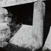
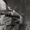
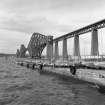
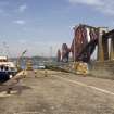
(Listed under South Queensferry, West Lothian; Ferry Landings: location cited as NT 1378, NT 1478). The jetty at the Hawes Inn (NT17NW 112), which was in use until the ferry closed in 1964, is about 935ft [285m] by 85ft [25.9m] wide, and is divided longitudinally by a wall which begins 45ft [13.7m] out from the landward end and runs for 620ft [189m], being broken after 130ft [39.6m] by a gap 25ft [7.6m]. The masonry is large rubble, well squared and coursed, and with droving: a ramp of the same build, grooved for a marginal iron strap, leads down to the beach on the E at the landward end. Much of the top is cemented, but in places the original setts may be seen, and marginal slabs with some lozenge shaped keys of cement. The central wall is of large, neatly droved and well coursed blocks, stands 7ft 8ins [2.3m] high, and has a slightly rounded coping secured in part with oblong keys; it is heavily battered on both sides, decreasing in thickness from 8ft [2.4m] at the base to 5ft 2ins [1.6m] at the top. At the S end, however, the faces are made vertical for 10ft 9ins [3.3m] to accommodate a small mural chamber, now an engine-house, with a door on the W and a window on the E, neither perhaps original. Three feet N of the N end of this chamber, the W face of the wall contains an open recess 10ft 3ins [3.1m] long, 5ft [1.5m] and 5ft 4ins [1.6m] high, with an arched roof; the lintel at the face is supported by a battered column 1ft 3ins [0.4m] in diameter, the back of which extends into a kind of buttress, vertical at the back and 7ins [0.18m] thick. On the N wall of the recess is fixed a heavy iron ratchet-wheel with the end of its axis squared to take a crank-handle; the presence of a hole in the roof immediately above suggests that this was part of the mechanism of a semaphore. A similar recess appears in the E face, 12ft [3.7m] further N; this contains no machinery, and the ceiling is lintelled.
A Graham 1971.
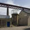
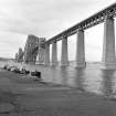
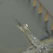
(Location cited as NT 137 784). Ferry pier, Queejsferry, built c. 1812, engineer John Rennie. A ramped masonry ferry pier with a central wall. At the landward end is a hexagonal lighthouse [NT17NW 172.01].
J R Hume 1976.
The Hawes Pier was [formerly, pre-1964] used by the ferry. Designed by Rennie and Stevenson, 1809-18, it has a little octagonal lighthouse [beacon: NT17NW 172.01] with rusticated base.
C McWilliam 1978.
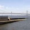
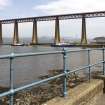
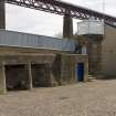
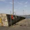
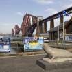
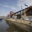
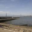
The pier is situated at the east end of Queensferry Promenade. The stone pier is in good condition and used by the RNLI.
Site recorded by GUARD during the Coastal Assessment Survey for Historic Scotland, 'The Firth of Forth from Dunbar to the Coast of Fife' 18th February 1996.
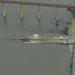
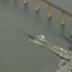
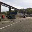
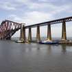
This pier is situated at the E end of the seafront (NT17NW 72) at South Queensferry, to the E of the village (NT17NW 175), and immediately W of the Forth Rail Bridge (NT17NW 70). The design of the structure is that of a sloping slipway rather than a normal pier; it is useable at all states of the tide.
Built and used until 1964 as the Southern terminus of the vehicular ferry across the Queensferry Narrows. Apart from use by recreational sailing vessels and motor cruisers, it now houses the local Inshore Rescue Boat station (NT17NW 172.02) and is the shore terminal for workboat sailings to the Hound Point terminals (NT17NE 65 and NT18SE 28).
Information from RCAHMS (RJCM), 3 March 2006.
Construction (1819)
Project (2007)
This project was undertaken to input site information listed in 'Civil engineering heritage: Scotland - Lowlands and Borders' by R Paxton and J Shipway, 2007.
Publication Account (2007)
Major improvements took place at the Queensferry landingstages in 1808–17 under Rennie’s direction, before the era of steam navigation and when sailings were much at the mercy of wind and sea. These included the ramped pier at Newhalls (Hawes) which by 1812 had been enlarged to about 240 yards in length with a central breakwater flanked by paving at a cost of £8696. Nearby Longcraig Pier (1817) is also a good example of Rennie’s pier work. Robert Stevenson advised on lighting arrangements at the piers. At Hawes Pier, erected ca.1817, he recommended repositioning the signal house reflector at the pier head at 12–15 ft above high water level, presumably the small hexagonal in plan lighthouse seen in the view which still exists. The light source would have been an Argand oil lamp.
R Paxton and J Shipway 2007
Reproduced from 'Civil Engineering heritage: Scotland - Lowlands and Borders' with kind permission of Thomas Telford Publishers.

