
Castlecraig


Temporary Camp (Roman)
Site Name Castlecraig
Classification Temporary Camp (Roman)
Canmore ID 50117
Site Number NT14SW 46
NGR NT 1256 4455
NGR Description Centred NT 1256 4455
Datum OSGB36 - NGR
Permalink http://canmore.org.uk/site/50117


- Council Scottish Borders, The
- Parish Kirkurd
- Former Region Borders
- Former District Tweeddale
- Former County Peebles-shire
NT14SW 46 centred 1256 4455.
A second Roman temporary camp, placed so as to occupy the highest ground, lies within NT14SW 37; 500ft of the SW and NW sides have been noted, and the ditch on the NW converges gradually with that of the larger camp, the two lines meeting at a gate which seems to have served both.
J K St Joseph 1965; RCAHMS 1967; J K St Joseph 1969.
There are no visible remains of this camp.
Visited by OS 7 November 1974.
Publication Account (17 December 2011)
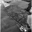
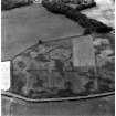
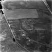
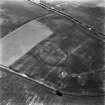
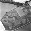
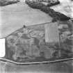
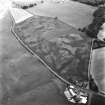
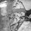
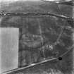
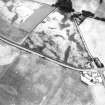
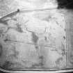
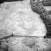
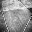
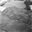
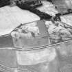
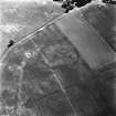
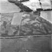
The two intersecting camps at Castlecraig by Kirkurd lie close to the line of the Roman road between Castledykes and Lyne/Easter Happrew and not far from the road running up the east side of the Pentland Hills. They are sited on undulating land below Galloberry Wood. Both were discovered as cropmarks by St Joseph from the air: the first in 1964 and the second four years later (1965: 79; 1969: 108).
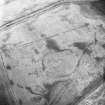
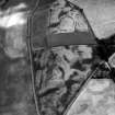
Only part of the perimeter of each camp is known. Camp I, the larger of the two, measures at least 525m from south-west to north-east by 332m transversely, enclosing at least 17ha (42 acres) and possibly some 21.1ha (52 acres). A titulus is visible in the south-east side, and two are visible in the north-west side. A number of linear cropmarks confuse the south-west side of the camp, and no entrance is clearly discernable on this side. One cropmark has an additional enclosure attached, but this does not appear to be an annexe and does not look Roman in form.
A second camp (Castlecraig II) is partially recorded on a slight knoll within camp I.
The visible part of the north-west side lies at a slight angle to the that of camp I, and the two camps come together at the entrance gap, protected by two tituli, presumably one for each camp. Some 150m of the southwest side of this camp is visible, with an entrance gap and titulus two-thirds of the way along this side. Of the northwest side, 111m up to the titulus is known; beyond this, the camp may have used the north-west perimeter of camp I, but this is unknown.
If the known gate on the north-west side represents the centre of that side, then the camp’s cross dimension would be 220m, suggesting that it enclosed at least 3.3ha(8.2 acres), and, given the location of the other entrance and the topography, may have enclosed some 4.3ha (10.7 acres). A number of linear cropmarks are visible to the south-east, but none can be confidently assigned to the camp.
The denuded remains of a stone circle survive within camp I’s perimeter (RCAHMS 1967: 63), and the cropmark remains of a settlement are visible within both camps alongside a probable palisaded enclosure, which overlaps the perimeter of camp II.
R H Jones
Sbc Note
Visibility: This site is visible as a cropmark.
Information from Scottish Borders Council

