|
Photographs and Off-line Digital Images |
DC 11096 P |
|
Map showing henge etc. at Manor, pen & pencil, ns. Photographic copy of a drawing. |
20/7/1935 |
Item Level |
|
|
Prints and Drawings |
PBD 315/1 |
|
Missing (1987) |
|
Item Level |
|
|
Prints and Drawings |
PBD 315/2 |
|
Map showing henge etc. at Manor, pen & pencil, ns. |
1935 |
Item Level |
|
|
Prints and Drawings |
PBD 50/1 |
Records of the Royal Commission on the Ancient and Historical Monuments of Scotland (RCAHMS), Edinbu |
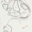
Publication drawing of the homestead and enclosure, The Bank |
1929 |
Item Level |
|
|
Prints and Drawings |
PBD 50/2 |
Records of the Royal Commission on the Ancient and Historical Monuments of Scotland (RCAHMS), Edinbu |
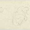
Plane table survey: settlement and homestead, The Bank |
1963 |
Item Level |
|
|
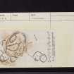
Prints and Drawings |
DC 58607 |
Records of the Society of Antiquaries of Scotland, Edinburgh, Scotland |
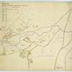
Plan of early settlement in the Manor Valley |
20/7/1935 |
Item Level |
|
 |
On-line Digital Images |
DP 192557 |
Records of the Society of Antiquaries of Scotland, Edinburgh, Scotland |
Plan of early settlement in the Manor Valley. |
20/7/1935 |
Item Level |
|
 |
On-line Digital Images |
DP 354697 |
Records of the Royal Commission on the Ancient and Historical Monuments of Scotland (RCAHMS), Edinbu |
Publication drawing of the homestead and enclosure, The Bank |
1929 |
Item Level |
|
 |
On-line Digital Images |
DP 354698 |
Records of the Royal Commission on the Ancient and Historical Monuments of Scotland (RCAHMS), Edinbu |
Plane table survey: settlement and homestead, The Bank |
1963 |
Item Level |
|
 |
On-line Digital Images |
SC 2438595 |
Records of the Ordnance Survey, Southampton, Hampshire, England |
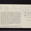
The Bank, NT13SE 11, Ordnance Survey index card, page number 1, Recto |
c. 1958 |
Item Level |
|
 |
On-line Digital Images |
SC 2438596 |
Records of the Ordnance Survey, Southampton, Hampshire, England |
The Bank, NT13SE 11, Ordnance Survey index card, page number 2, Verso |
c. 1958 |
Item Level |
|
 |
On-line Digital Images |
SC 2438597 |
Records of the Ordnance Survey, Southampton, Hampshire, England |
The Bank, NT13SE 11, Ordnance Survey index card, page number 3, Recto |
c. 1958 |
Item Level |
|
 |
On-line Digital Images |
SC 2438598 |
Records of the Ordnance Survey, Southampton, Hampshire, England |
The Bank, NT13SE 11, Ordnance Survey index card, page number 4, Verso |
c. 1958 |
Item Level |
|
 |
On-line Digital Images |
SC 2438599 |
Records of the Ordnance Survey, Southampton, Hampshire, England |
The Bank, NT13SE 11, Ordnance Survey index card, page number 5, Recto |
c. 1958 |
Item Level |
|
 |
On-line Digital Images |
SC 2438600 |
Records of the Ordnance Survey, Southampton, Hampshire, England |
The Bank, NT13SE 11, Ordnance Survey index card, Recto |
c. 1958 |
Item Level |
|
 |
On-line Digital Images |
SC 2438601 |
Records of the Ordnance Survey, Southampton, Hampshire, England |
The Bank, NT13SE 11, Ordnance Survey index card, Recto |
c. 1958 |
Item Level |
|
|
All Other |
551 166/1/1 |
Records of the Ordnance Survey, Southampton, Hampshire, England |
Archaeological site card index ('495' cards) |
1947 |
Sub-Group Level |
|


