
The Bank


Settlement (Iron Age)
Site Name The Bank
Classification Settlement (Iron Age)
Alternative Name(s) Kirkhope
Canmore ID 49887
Site Number NT13SE 11
NGR NT 1954 3052
Datum OSGB36 - NGR
Permalink http://canmore.org.uk/site/49887


- Council Scottish Borders, The
- Parish Manor
- Former Region Borders
- Former District Tweeddale
- Former County Peebles-shire
NT13SE 11 1954 3052.
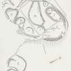
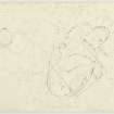
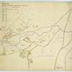
(NT 1954 3052) On the N extremity of The Bank, a spur projecting NE from Dollar Law into the Manor Valley, there is a complicated series of structures, all of which are in an extremely ruinous condition. The remains are partly obscured by a plantation of conifers and by the foundations of relatively recent walls and buildings, but at least three different types of early domestic sites can be recognised. The earliest of these is a settlement which measures 210ft by 150ft within a boulder-faced, rubble-cored wall 10ft thick (A on RCAHMS 1967 plan, fig. 29). The entrance on the E is partly blocked by a modern dry-stone dyke, while the interior is largely occupied by a later settlement (H,J) but three platforms for timber houses (1-3) can still be distinguished, the largest (I) measuring 35ft across.
A second type of domestic site is represented by four scooped homesteads, three of which (B,C.D) are contiguous and partly overlie the wall of the original settlement, while the fourth (E) is situated some 40yds to the SE. The westernmost scooped home- stead (B) measures 80ft by 60ft within a boulder-faced rubble wall about 6ft thick, the NE sector of which incorporates a stretch of wall A. The greater part of the upper level of the interior is occupied by a house-platform measuring 25ft across; the excavated court, measuring internally 55ft by 45ft, contains a large boulder which stands to a height of 3ft 6 ins. There are two entrances, on the N and S sides respectively. A stony bank running N from the W side of the N entrance forms part of a subsidiary enclosure (F) measuring 40ft across. The S entrance leads into a second scooped homestead (C) measuring 80ft by 50ft within a boulder-faced rubble wall, 6 ft thick, the NE sector of which incorporates a stretch of wall A. The upper level of the interior contains a house-platform 25 ft in width. The excavated court, which measures 50 ft across has an entrance on the S side; it is 8ft wide and is faced with boulders. A third scooped homestead (D), which lies almost entirely within the earlier settlement, measures only 50ft by 40ft, and most of its surrounding wall has disappeared. The upper level consists of a house- platform, measuring about 15ft in diameter, on the W side of which there is a line of debris, 18ft in length, which is apparently of later date. The court measures 30ft by 20ft and has an entrance on the S. The fourth scooped homestead (E) is in extremely ruinous condition, the outer wall now appearing as a low scarp. On the SE this homestead is partly overlain by an enclosure (G) measuring 60ft by 55ft within a boulder-faced rubble wall, about 8ft thick, in which no entrance can be discerned.
The third type of habitation-site, a settlement characterised by circular stone houses (4 and 5) with associated walled courts (H,J,K) is in such a ruinous condition that no clear idea of the original plan can now be obtained. It occupies a considerable portion of the interior of the original settlement, but also extends beyond it on the NW.
Thus, in spite of the wrecked condition of the remains, it is clear that the settlement formed by wall A, and containing timber houses, was superseded both by the scooped homesteads and by the settlement with stone houses. Although the later works are themselves nowhere in contact, there is every reason to suppose that the scooped homesteads preceded the settlement with stone houses.
RCAHMS 1967, visited 1963; R W Feachem notebook 1963.
These grass and bracken-covered remains are as described.
All the platforms noted by RCAHMS are visible, those within the plantation however being difficult to distinguish.
Enclosures B and F have been disturbed by forestry ploughing.
Re-surveyed at 1/2500.
Visited by OS(EGC) 23 June 1961 and (BS) 4 october 1974.
Sbc Note
Visibility: This is an upstanding earthwork or monument.
Information from Scottish Borders Council

