
Pricing Change
New pricing for orders of material from this site will come into place shortly. Charges for supply of digital images, digitisation on demand, prints and licensing will be altered.
Frenchland


Tower House (Medieval)
Site Name Frenchland
Classification Tower House (Medieval)
Alternative Name(s) Frenchland Tower; Frenchlands
Canmore ID 49725
Site Number NT10NW 4
NGR NT 10173 05372
Datum OSGB36 - NGR
Permalink http://canmore.org.uk/site/49725


- Council Dumfries And Galloway
- Parish Moffat
- Former Region Dumfries And Galloway
- Former District Annandale And Eskdale
- Former County Dumfries-shire
NT10NW 4 10173 05372
(NT 1016 0537) Frenchland Tower (NR) (Ruins of)
OS 6" map, (1898-1938)
This tower was inhabited as late as 1720, and in 1857 the walls still stood erect.
Name Book 1857.
Originally a simple keep, this building has been extended at a later time into a mansion of the L-plan. Some of the corbels of the parapet of the original keep have been left in the N gable when the latter was heightened and finished with crow-steps. The door of the enlarged structure was in the re-entering angle of the W wing, which was added in order to contain a good square staircase as far up as the hall and bedrooms on the upper floors. The old keep is 26 ft 8 ins (8.1m) by 21 ft 6 ins (6.6m) wide, and the walls are 3 ft 6 ins (1.1m) thick. It is probably an erection of the 16th century, while the wing, which measures 15 ft 8 ins (4.8m) by 13 ft (4m), and other enlargements have been added in the 17th century.
D MacGibbon and T Ross 1889-92.
Frenchland Tower was originally oblong in plan, unvaulted, with a parapet carried on corbels, and was probably built in the 16th century. At some later period, possibly in the 17th century, the tower was modernised, the parapet was removed, and a high pitched roof substituted. A wing was thrown out on the W, making the tower a mansion of the L-plan type, to contain a staircase wider and more suited to the requirements of the dwelling than the original wheel-stair.
RCAHMS 1920
The remains of this tower are as described. The walls stand generally to the wall-head except on the N side and at the re-entrant angle where there are gaps down to almost ground level.
Visited by OS (RD) 7 December 1971
The French family held land here as tenants of the Bruces in the early 13th century. In the 16th century they built a three-storey tower measuring 8m by 6.3m with a tiny spiral stair squeezed in the SW corner. In the early 17th Robert French added a turret on the W side to contain a wide stair from a new entrance to the hall and a bedroom at third storey level. It was perhaps at the same that the main tower was remodelled without the former open wall-walk and parapet. The side walls have mostly fallen but the gables stand intact.
M Salter 1993.
Ruin of a rubble-built three-storey-and-attic L-plan laird's house, the main block likely to have been constructed in the mid-16th century by the Frenches of Frenchland, its upper part remodelled and the SW jamb added probably early in the 17th century.
J Gifford 1996.
Description:
Tower house built probably in 16th century, jamb added at S end of W wall in 17th century, forming L-plan. All rubble-built with ashlar dressings, some deep corbels at upper level. Roofless, and in poor condition.
Notes:
Scheduled Ancient Monument.
References:
RCAHM INVENTORY, 1920 no. 480.
De-listed September 2009
(Undated) information from Historic Scotland.
Scheduled as 'Frenchland Tower, tower house... the remains of a multi-phase, L-shaped tower-house, probably built in the 16th century.'
Information from Historic Scotland, scheduling document dated 16 March 2010.
Frenchland Tower
(remains of) [NAT]
OS (GIS) MasterMap, April 2010.
Field Visit (15 May 1990)
NT 1016 0537 NT10NW 4
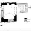
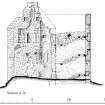
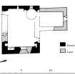
The roofless ruin of this late 16th- or early 17th-century tower-house consists of a main block three stories and an attic in height which was converted to the L-plan in the 17th century by the addition of a wing. The tower (8.1m from W to E by 6.5m transversely over walls about 1m thick) is constructed of lime-mortared random rubble with sandstone dressings. Window margins are either bullnosed or have chamfered arrises (those in the wing are exclusively the latter). The roof was originally thatched but latterly was slated with eaves finishing in plain copes. The entrance-doorway was probably at the E end of the S wall and opened to an unvaulted basement and newel-stair accommodated in the SE angle of the main block and rising its full height. The first floor, divided into a hall and chamber, had gable fireplaces; that on the W was subsequently infilled (as part of a wider remodelling of the gable-wall, its voussoirs remain) along with an adjacent window on its S side. The fireplace in the E wall was lit by a slit-window in its rear wall and a splayed opening in the N jamb may indicate the presence of another. This arrangement is suggestive of an ingleneuk. There is an aumbry at the W end of the S and N wall respectively. The third floor, divided into two compartments, also had gable fireplaces and windows, and may originally have been open to the roof. Slit windows, however, suggest at some date the provision of an attic floor. A door at the S end of the W wall, at third-floor level, gave access to a corbelled timber parapet; only the corbelling remains. The door was subsequently blocked and a window contrived in the inserted masonry. It too was later blocked externally. The 17th-century wing contained a scale-and-plait staircase rising from ground to first-floor levels with additional accommodation on the floors above. To allow for this, the original newel-stair was removed beneath first-floor level. A slit-window at ground level in the wing probably lit a chamber beneath the stair. Peripheral to the tower there are traces of an enclosure and, on the SE, what may be an outbuilding. In 1610 the estate was the property of Robert Frenchie.
Visited by RCAHMS (IMS), 15 May 1990.
(D MacGibbon and T Ross 1889-92).
Frenchland Tower. Listed as tower.
RCAHMS 1997.
Measured Survey (25 October 1990 - 26 October 1990)
RCAHMS surveyed Frenchland Tower between 25-26 October 1990 with plane-table and alidade at a scale of 1:100 producing ground- and first-floor plans (indicating phases of construction) with sections NNE-SSW across the main block and NW wing. The plans and the section across the main block were redrawn in ink and published at a scale of 1:200 (RCAHMS 1997, Fig. 232).

