
Kinglass Park


Temporary Camp (Roman)
Site Name Kinglass Park
Classification Temporary Camp (Roman)
Alternative Name(s) Bo'ness, St Mary's Primary School; Grahamsdyke; Bents Cottage; Kinglass Park; Gauze Road; Newtown
Canmore ID 49522
Site Number NT08SW 10
NGR NT 00320 81010
Datum OSGB36 - NGR
Permalink http://canmore.org.uk/site/49522


- Council Falkirk
- Parish Bo'ness And Carriden
- Former Region Central
- Former District Falkirk
- Former County West Lothian
NT08SW 10.00 00320 81010
(NT 00320 81010) Roman Camp (R) (site of)
OS 6" map, (1971)
NT08SW 10.01 NT 0039 8107 Trial Excavation
For buildings linked georaphically with this camp, see:
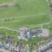
NT08SW 157 NT 00211 81055 St Mary's Roman Catholic Primary School
NT08SW 158 NT 00349 81036 Bents Cottage
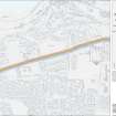
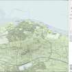
A Roman temporary camp is visible on air photographs near Kinglass Park, S of Bo'ness. A ditch 450' long may mark the S side and rounded SW angle of a camp (J K St Joseph 1951). The part of the camp not visible on air photographs was located by probing in 1955. Its size is about 500' square.
(Visible on St Joseph air photographs BD 55, 56, JP 94).
J K St Joseph 1951; J K St Joseph 1955.
There is no trace of this site on the ground.
Visited by OS (B S) 12 March 1967.
No change to previous OS field surveyor. The estimated area of the camp is mainly under housing; the visible portion on air photographs being within the lawned grounds of a school.
Visited by OS (J R L) 15 April 1980.
Scheduled as 'Bents Cottage, Roman temporary camp 40m SW, 75mSW & 75m NE of... the buried remains of a Roman temporary camp visible as the cropmarks of its defensive ditches on oblique aerial photographs. The majority of the camp lies within the grounds of St Mary's Primary School, Bo'ness, with further remains lying to the NNE in Kinglass Park and in amenity parkland immedieately adjacent.'
Information from Historic Scotland, scheduling document dated 25 June 2010.
Aerial Photography (9 July 1952)
Aerial Photography (2 August 1956)
Aerial Photographic Transcription (1965)
Field Visit (12 March 1967)
There is no trace of this site on the ground.
Visited by OS (B S) 12 March 1967.
Aerial Photography (27 July 1968)
Note (1978)
Kinglass Park NT 003 809 NT08SW 10
Listed as temporary camp
RCAHMS 1978
(St Joseph 1951, 62; 1955, 86)
Field Visit (15 April 1980)
No change to previous OS field surveyor. The estimated area of the camp is mainly under housing; the visible portion on air photographs being within the lawned grounds of a school.
Visited by OS (J R L) 15 April 1980.
Watching Brief (21 June 1998)
NT 0039 8107 Topsoil was stripped from the solum of a new house at 1 Gauze Road which lies over the previously reported line of the E ditch of Kinglass Roman temporary camp. However, no trace of the ditch was found.
Sponsor: Douglas Brown.
G Bailey 1999
Publication Account (2008)
A 1:25000 scale map of the Antonine Wall was published by RCAHMS in 2008. The map shows the course of the Antonine Wall on a modern map base, including areas where the Wall is in public ownership or care and can be visited. The data had been collated as part of the project to prepare maps for the World Heritage Site nomination bid.
Publication Account (17 December 2011)
The camp at Kinglass Park was first discovered as a cropmark from the air by St Joseph in 1948 (1951a: 62), and sits on level ground just to the south of the presumed line of the Antonine Wall along Dean Road (Grahamsdyke Road).
The air photographs reveal about 115m of the south side, a rounded south-west angle and 31m of the west side of the camp, the remainder lying under the Newtown area of Boness, including a school. Feachem identified a possible titulus on the west side of the camp from the air photographs, but this could not be confirmed. He also recorded part of the west and east sides and the northeast corner through probing, leading him to suggest that the camp measured about 490ft (149m) square, enclosing about 5.5 acres (2.2 acres) (1958: 334–5). However, a watching brief in 1998 on the presumed eastern side of the camp revealed no trace of ditch, and the excavator also noted the heavy terracing that had taken place around the north-east corner and questioned the results found by Feachem (Bailey 1998; Keppie 1999: 329). As a result, it is no longer possible to confirm the perimeter of the camp, beyond what has been recorded on the air photographs.
R H Jones.
Aerial Photography

