|
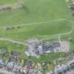
Photographs and Off-line Digital Images |
WL 1434 PO |
Cambridge University Collection for Aerial Photography |
Aerial view |
|
Item Level |
|
|
Photographs and Off-line Digital Images |
WL 1435 PO |
Cambridge University Collection for Aerial Photography |
Aerial view |
|
Item Level |
|
|
Prints and Drawings |
WLD 53/1 |
|
Plan, ink, ns R.W. FEACHEM (PSAS LXXXIX, p. 333) |
|
Item Level |
|
|
Prints and Drawings |
WLD 53/2 |
|
Plan, ink, 1":100' R.W. Feachem |
|
Item Level |
|
|
Photographs and Off-line Digital Images |
G 99512 PO |
Cambridge University Collection for Aerial Photography |
Oblique aerial view |
9/7/1952 |
Item Level |
|
|
Photographs and Off-line Digital Images |
G 99513 PO |
Cambridge University Collection for Aerial Photography |
Oblique aerial view |
2/8/1956 |
Item Level |
|
|
Photographs and Off-line Digital Images |
G 99514 PO |
Cambridge University Collection for Aerial Photography |
Oblique aerial view |
27/7/1968 |
Item Level |
|
|
Photographs and Off-line Digital Images |
G 99515 PO |
Cambridge University Collection for Aerial Photography |
Oblique aerial view |
27/7/1968 |
Item Level |
|
|
Manuscripts |
MS 2724 |
|
Report - Archaeological watching brief at Kinglass Park Roman Temporary Camp, 1 Gauze Road, Falkirk, 1998. |
21/6/1998 |
Item Level |
|
 |
On-line Digital Images |
DP 249484 |
Historic Environment Scotland |
Oblique aerial view. |
24/3/2017 |
Item Level |
|
|
Photographs and Off-line Digital Images |
SC 1916183 |
Cambridge University Collection for Aerial Photography |
Aerial view |
|
Item Level |
|
|
Photographs and Off-line Digital Images |
SC 1916184 |
Cambridge University Collection for Aerial Photography |
Aerial view |
|
Item Level |
|
|
Photographs and Off-line Digital Images |
SC 1918822 |
Cambridge University Collection for Aerial Photography |
Oblique aerial view |
9/7/1952 |
Item Level |
|
|
Photographs and Off-line Digital Images |
SC 1918823 |
Cambridge University Collection for Aerial Photography |
Oblique aerial view |
2/8/1956 |
Item Level |
|
|
Digital Files (Non-image) |
GV 007505 |
Records of Historic Scotland, Edinburgh, Scotland |
Map 1 of 8 from IV.I 1-8 - Series 1: Maps of the Antonine Wall at a scale of 1:25000 showing the proposed World Heritage Site, known forts and fortlets, camps, other features and the buffer zones. Maps were prepared for the nomination document to propose the extension of the Frontiers of the Roman Empire World Heritage Site through the addition of the Antonine Wall. |
2006 |
Item Level |
|
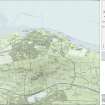 |
On-line Digital Images |
SC 1919937 |
Records of Historic Scotland, Edinburgh, Scotland |
Map 1 of 8 from IV.I 1-8 - Series 1: Maps of the Antonine Wall at a scale of 1:25000 showing the proposed World Heritage Site, known forts and fortlets, camps, other features and the buffer zones. Maps were prepared for the nomination document to propose the extension of the Frontiers of the Roman Empire World Heritage Site through the addition of the Antonine Wall. |
2006 |
Item Level |
|
|
Digital Files (Non-image) |
GV 007508 |
Records of Historic Scotland, Edinburgh, Scotland |
Map 1 of 8 from IV.2 1-8 - Series 2: Maps of the Antonine Wall at a scale of 1:25000 showing the proposed World Heritage Site, known forts and fortlets, camps, other features and the buffer zones. Maps were prepared for the nomination document to propose the extension of the Frontiers of the Roman Empire World Heritage Site through the addition of the Antonine Wall. |
2006 |
Item Level |
|
 |
On-line Digital Images |
SC 1926676 |
Records of Historic Scotland, Edinburgh, Scotland |
Map 1 of 8 from IV.2 1-8 - Series 2: Maps of the Antonine Wall at a scale of 1:25000 showing the proposed World Heritage Site, known forts and fortlets, camps, other features and the buffer zones. Maps were prepared for the nomination document to propose the extension of the Frontiers of the Roman Empire World Heritage Site through the addition of the Antonine Wall. |
2006 |
Item Level |
|
|
Photographs and Off-line Digital Images |
SC 1927854 |
Cambridge University Collection for Aerial Photography |
Oblique aerial view |
27/7/1968 |
Item Level |
|
|
Photographs and Off-line Digital Images |
SC 1927855 |
Cambridge University Collection for Aerial Photography |
Oblique aerial view |
27/7/1968 |
Item Level |
|
|
Digital Files (Non-image) |
GV 007532 |
Records of Historic Scotland, Edinburgh, Scotland |
Map 3 of 39 from Series V. Maps of the Antonine Wall and its known features at a scale of 1:5000 showing the scheduled areas and the proposed World Heritage Site. Maps were prepared for the nomination document to propose the extension of the Frontiers of the Roman Empire World Heritage Site through the addition of the Antonine Wall. |
2006 |
Item Level |
|
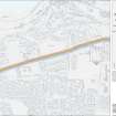 |
On-line Digital Images |
SC 1928155 |
Records of Historic Scotland, Edinburgh, Scotland |
Map 3 of 39 from Series V. Maps of the Antonine Wall and its known features at a scale of 1:5000 showing the scheduled areas and the proposed World Heritage Site. Maps were prepared for the nomination document to propose the extension of the Frontiers of the Roman Empire World Heritage Site through the addition of the Antonine Wall. |
2006 |
Item Level |
|
|
Digital Files (Non-image) |
GV 007596 |
Records of Historic Scotland, Edinburgh, Scotland |
Antonine Wall 1:25000 broadsheet map - created in three sections - this is the eastern section of the map |
2008 |
Item Level |
|
 |
On-line Digital Images |
SC 1970706 |
Records of Historic Scotland, Edinburgh, Scotland |
Antonine Wall 1:25000 broadsheet map |
2008 |
Item Level |
|


