
Cow Castle


Fort (Iron Age), Settlement (Iron Age)
Site Name Cow Castle
Classification Fort (Iron Age), Settlement (Iron Age)
Alternative Name(s) Nisbet
Canmore ID 48745
Site Number NT03SW 14
NGR NT 0425 3311
Datum OSGB36 - NGR
Permalink http://canmore.org.uk/site/48745


- Council South Lanarkshire
- Parish Culter
- Former Region Strathclyde
- Former District Clydesdale
- Former County Lanarkshire
NT03SW 14 0425 3311.
(NT 0425 3311) Cow Castle (NAT) Fort (NR)
OS 6" map, (1962)
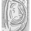
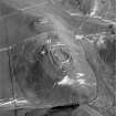
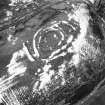
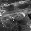
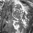
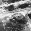
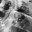
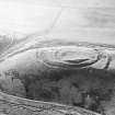
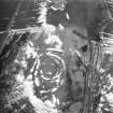
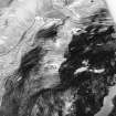
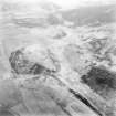
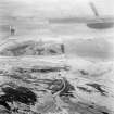
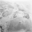
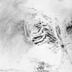
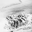
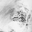
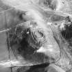
Fort, Cow Castle: This fort occupies a prominent position on the SW end of an isolated ridge 550m NE of Nisbet farmhouse. The site is easily accessible from the NE along the crest of the ridge, but on all other sides steep slopes provide considerable protection. The complex remains have been damaged by cultivation, quarrying, and stone-robbing, and in consequence are difficult to interpret from surface remains alone. However, at least two structural periods seem to be involved.
The earlier period is represented by two ramparts (IA and IB, see RCAHMS 1978 plan, fig.55) which have enclosed a roughly oval area measuring about 85m by 46m. Much of the material used in their formation has been derived from a medial ditch, which, together with the ramparts, is best preserved on the SW; here the inner and outer ramparts rise to heights of 2.4m and 0.8m respectively above the bottom of the ditch. As the ditch is almost completely rock-cut in many places, the ramparts have contained a high proportion of rock rubble, and the inner rampart has been supplemented by material provided by internal surface-quarrying, evidence for which can still be seen in the form of a broad, shallow depression extending along its inner edge on the SW. A few stones belonging to an external revetment to rampart IA can be seen on the W and SW. Along the NW and SE sides both ramparts are reduced for the most part to mere scarps or crest lines, with the interval between them remaining fairly constant, but at the NE end what appears to be a continuation of rampart IB diverges so far from rampart IA as to leave room to accommodate a circular house of ring-ditch type on the level interspace. The reason for this divergence is not clear. The entrances on the NNE and WSW are both probably original, but the former has been enlarged by ploughing, which has penetrated some distance into the interior at this point.
In a later phase the size of the fort was reduced by the construction of two new ramparts (IIA and IIB) to enclose an area measuring 43m by 27m. These ramparts are best preserved on the SW, standing up to 0.9m above their respective ditches. Rampart IIA can still be seen for most of its original circuit, and a short stretch of stones belonging to an outer revetment is visible on the SE, where the rampart runs over the crest of a rocky knoll, 4.9m high, which occupies about a quarter of the interior. By contrast, it is now difficult to distinguish rampart IIB with certainty, but it appears to have followed approximately the same course as the earlier rampart IA. The entrance, on the WSW, which passes through both IIA and IIB, is well marked, but a gap in IIA on the NW is clearly of recent origin. Within the interior there are the fragmentary indications of three ring-ditch houses, each measuring about 6.1m in internal diameter.
RCAHMS 1978, visited 1975.
This monument was generally as described by the RCAHMS when seen in 1972. The second phase was interpreted as a settlement because of the ring-ditch houses in the interior.
Revised at 1/2500.
Visited by OS(DWR) 18 July 1972.
Photographed by the RCAHM in 1980.
RCAHMS AP catalogue 1980.
Visible on vertical air photograph (OS 71/505/603, flown 1971)
Information from RCAHMS (RJCM) April 1991.
Publication Account (1985)
The gorge of the Culter Water provides access to an attractive group of minor valleys containing a remarkable collection of prehistoric and later monuments, which include at least six defended settlements, a crannog and numerous cultivation terraces.
The best preserved of the remains is the multi-period fort known as Cow Castle. On the ground its jumble of ramparts is difficult to disentangle, but with the aid of an aerial photograph and an interpretative plan, the various phases can be readily distinguished. Two main periods are represented, with the defences of the earlier work being partially overlain or reused in the later phase. In Period 1 the defences comprise two ramparts and ditches (lA and B) with, on the inner side of the south section of lA, a quarry scoop dug to provide additional material for the rampart. Access was provided by two inturned gateways placed close to the steep north-west flank of the hill. This is a characteristic position for gateways on prehistmic earthworks, as it makes maximum use of the defensive potential of the site, while on similar medieval sites the entrances are frequently more centrally placed. In the second period the area enclosed was reduced in size with the construction of ramparts HA and B, but wherever possible sections of the earlier defences were used. Traces of at least three ling-ditch houses are visible within the forti one, on the north-east, appears to belong to Period 1 as its outer wall-line is cut by the Period H ditch, and the others were probably built during Period II (although their wall-lines must have become very close to the rampart).
Information from ‘Exploring Scotland’s Heritage: The Clyde Estuary and Central Region’, (1985).
Note (29 July 2015 - 19 October 2016)
This fort is situated on part of a long steep-sided ridge that rises up on the SE side of the valley at the foot of Black Hill. Cleft in two by a deep gully, the fort itself stands on the SW end of the NE portion of the ridge, including its summit knoll into the defences, and another settlement enclosure occupies its NE tip (Canmore 48746). The fort has been heavily disturbed by stone-robbing, but the defences evidently represent several periods of construction, and the sequence is probably more complex than the two structural periods identified in 1975 by RCAHMS investigators, in which a fort enclosing the whole of this end of the crest of the ridge was superseded by a smaller bivallate enclosure (RCAHMS 1978, 98-100, no.226); indeed it is likely that the supposedly bivallate defences of the innermost enclosure themselves represent at least two periods of construction, contracting in the later into an oval enclosure largely in the lea of the summit knoll and measuring no more than 43m from N to S by 27m transversely (0.09ha) within a stony bank. This bank does not take a particularly sensible line for a defensive work, whereas the roughly concentric rampart that surrounds it adopts the inner rampart of the earliest circuit for the greater part of its course, only diverging where it cuts back across the interior on the SW; here it is not only accompanied by an external ditch, but also an internal quarry ditch riding up onto the summit knoll behind the rampart. Possibly once an enclosure in its own right, this rampart takes in an area measuring 62m from NE to SW by 47m transversely (0.2ha). What is thought to be the earliest enclosure is larger again, measuring 85m from NE to SW by 46m transversely (0.34ha) within two ramparts, the inner of which on the SW stands 2.4m above the bottom of a medial ditch up to 5m broad. The two ramparts, however, are not entirely concentric and on the NE the outer apparently diverges to enclose an additional area of ground, extending along the crest of the natural slope on the SE for a further 25m, before cutting sharply back with an external ditch towards the NW. Here, just short of the lip of the slope, it returns at right angles to form the SE side of an entrance way leading to a gap in the inner rampart at the N extremity of the interior; a second entrance lies in a similar position at the SW end of the interior, though here the inner of the two ramparts turns inwards to flank the entrance way, thus exposing the visitor’s right side. While this additional enclosure on the NE is possibly an annexe, and contains evidence of a large timber round-house with an internal ring-ditch, it is also possible that this originated as part of an even earlier enclosure on this hilltop. In addition to this round-house, at least three others can be seen within the interior of the innermost enclosure.
Information from An Atlas of Hillforts of Great Britain and Ireland – 19 October 2016. Atlas of Hillforts SC3233

