 |
On-line Digital Images |
SC 1917699 |
Records of the Royal Commission on the Ancient and Historical Monuments of Scotland (RCAHMS), Edinbu |
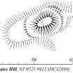
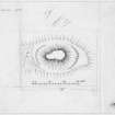
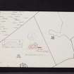
Publication drawing; Plan of Coats Hill motte. |
21/2/1995 |
Item Level |
|
|
Digital Files (Non-image) |
GV 007464 |
Records of the Royal Commission on the Ancient and Historical Monuments of Scotland (RCAHMS), Edinbu |
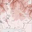
Map showing the distribution of timber and stone castles in Eastern Dumfriesshire and the neighbouring parts of Nithsdale and northern England. Published in Eastern Dumfriesshire: an archaeological landscape. |
1996 |
Item Level |
|
 |
On-line Digital Images |
SC 1917782 |
Records of the Royal Commission on the Ancient and Historical Monuments of Scotland (RCAHMS), Edinbu |
Map showing the distribution of timber and stone castles in Eastern Dumfriesshire and the neighbouring parts of Nithsdale and northern England. Published in Eastern Dumfriesshire: an archaeological landscape. |
1996 |
Item Level |
|
 |
On-line Digital Images |
DP 380552 |
Records of the Royal Commission on the Ancient and Historical Monuments of Scotland (RCAHMS), Edinbu |
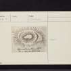
Publication drawing; plan of motte, Coats Hill (RCAHMS 1920 fig. 93) |
1912 |
Item Level |
|
 |
On-line Digital Images |
SC 2435425 |
Records of the Ordnance Survey, Southampton, Hampshire, England |
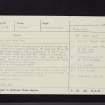
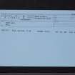
Coats Hill, NT00SE 12, Ordnance Survey index card, Recto |
1958 |
Item Level |
|
 |
On-line Digital Images |
SC 2435426 |
Records of the Ordnance Survey, Southampton, Hampshire, England |
Coats Hill, NT00SE 12, Ordnance Survey index card, Recto |
1958 |
Item Level |
|
 |
On-line Digital Images |
SC 2435427 |
Records of the Ordnance Survey, Southampton, Hampshire, England |
Coats Hill, NT00SE 12, Ordnance Survey index card, Recto |
1958 |
Item Level |
|
 |
On-line Digital Images |
SC 2435428 |
Records of the Ordnance Survey, Southampton, Hampshire, England |
Coats Hill, NT00SE 12, Ordnance Survey index card, Recto |
1958 |
Item Level |
|
 |
On-line Digital Images |
SC 2498306 |
|
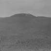
General view of motte. |
c. 1910 |
Item Level |
|
|
All Other |
551 166/1/1 |
Records of the Ordnance Survey, Southampton, Hampshire, England |
Archaeological site card index ('495' cards) |
1947 |
Sub-Group Level |
|


