|
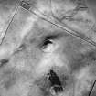
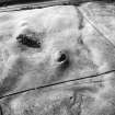
Photographs and Off-line Digital Images |
B 16773 |
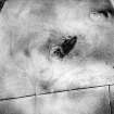
RCAHMS Aerial Photography |
Oblique aerial view. |
1988 |
Item Level |
|
|
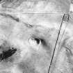
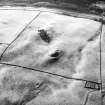
Photographs and Off-line Digital Images |
B 16774 |
RCAHMS Aerial Photography |
Oblique aerial view. |
1988 |
Item Level |
|
|
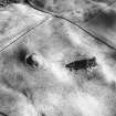
Photographs and Off-line Digital Images |
B 16775 |
RCAHMS Aerial Photography |
Oblique aerial view. |
1988 |
Item Level |
|
|
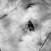
Photographs and Off-line Digital Images |
B 16776 |
RCAHMS Aerial Photography |
Oblique aerial view. |
1988 |
Item Level |
|
|
Photographs and Off-line Digital Images |
B 16779 |
RCAHMS Aerial Photography |
Oblique aerial view. |
1988 |
Item Level |
|
|
Photographs and Off-line Digital Images |
B 16780 |
RCAHMS Aerial Photography |
Oblique aerial view. |
1988 |
Item Level |
|
|
Photographs and Off-line Digital Images |
B 16781 |
RCAHMS Aerial Photography |
Oblique aerial view. |
1988 |
Item Level |
|
|
Prints and Drawings |
DFD 18/1 |
Records of the Royal Commission on the Ancient and Historical Monuments of Scotland (RCAHMS), Edinbu |
Publication drawing; plan of motte, Coats Hill (RCAHMS 1920 fig. 93) |
1912 |
Item Level |
|
|
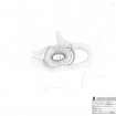
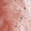
Prints and Drawings |
DC 32336 |
Records of the Royal Commission on the Ancient and Historical Monuments of Scotland (RCAHMS), Edinbu |
Survey drawing; Plan of Coats Hill motte, indicating topography. |
6/6/1990 |
Item Level |
|
|
Prints and Drawings |
DC 32498 |
Records of the Royal Commission on the Ancient and Historical Monuments of Scotland (RCAHMS), Edinbu |
Publication drawing; Plan of Coats Hill motte. |
21/2/1995 |
Item Level |
|
|
Prints and Drawings |
DC 32166 |
Records of the Royal Commission on the Ancient and Historical Monuments of Scotland (RCAHMS), Edinbu |
Upper Annandale landscape case-study area: map showing the medieval and later monuments, and the lands of the estates of Crunzierton in 1361 and Dumgree in 1605. Published in Eastern Dumfriesshire: an archaeological landscape. |
1996 |
Item Level |
|
|
Prints and Drawings |
DC 32228 |
Records of the Royal Commission on the Ancient and Historical Monuments of Scotland (RCAHMS), Edinbu |
This map shows the distribution of timber and stone castles in Eastern Dumfriesshire and the neighbouring parts of Nithsdale and northern England. Published in Eastern Dumfriesshire: an archaeological landscape. |
1996 |
Item Level |
|
|
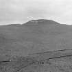
Photographs and Off-line Digital Images |
DF 33 |
|
General view of motte. |
c. 1910 |
Item Level |
|
 |
On-line Digital Images |
SC 1172723 |
|
General view of motte. |
c. 1910 |
Item Level |
|
 |
On-line Digital Images |
SC 1346116 |
Records of the Royal Commission on the Ancient and Historical Monuments of Scotland (RCAHMS), Edinbu |
Survey drawing; Plan of Coats Hill motte. |
6/6/1990 |
Item Level |
|
 |
On-line Digital Images |
SC 1729579 |
RCAHMS Aerial Photography |
Oblique aerial view. |
1988 |
Item Level |
|
 |
On-line Digital Images |
SC 1729580 |
RCAHMS Aerial Photography |
Oblique aerial view. |
1988 |
Item Level |
|
 |
On-line Digital Images |
SC 1729581 |
RCAHMS Aerial Photography |
Oblique aerial view. |
1988 |
Item Level |
|
 |
On-line Digital Images |
SC 1729582 |
RCAHMS Aerial Photography |
Oblique aerial view. |
1988 |
Item Level |
|
 |
On-line Digital Images |
SC 1729585 |
RCAHMS Aerial Photography |
Oblique aerial view. |
1988 |
Item Level |
|
 |
On-line Digital Images |
SC 1729586 |
RCAHMS Aerial Photography |
Oblique aerial view. |
1988 |
Item Level |
|
 |
On-line Digital Images |
SC 1729587 |
RCAHMS Aerial Photography |
Oblique aerial view. |
1988 |
Item Level |
|
|
Digital Files (Non-image) |
GV 007434 |
Records of the Royal Commission on the Ancient and Historical Monuments of Scotland (RCAHMS), Edinbu |
Upper Annandale landscape case-study area: map showing the medieval and later monuments, and the lands of the estates of Crunzierton in 1361 and Dumgree in 1605. Published in Eastern Dumfriesshire: an archaeological landscape. |
1996 |
Item Level |
|
 |
On-line Digital Images |
SC 1917404 |
Records of the Royal Commission on the Ancient and Historical Monuments of Scotland (RCAHMS), Edinbu |
Upper Annandale landscape case-study area: map showing the medieval and later monuments, and the lands of the estates of Crunzierton in 1361 and Dumgree in 1605. Published in Eastern Dumfriesshire: an archaeological landscape. |
1996 |
Item Level |
|


