
Coats Hill


Motte (Medieval)
Site Name Coats Hill
Classification Motte (Medieval)
Alternative Name(s) Coates Hill; Coatshill Quarry; St Margaret's
Canmore ID 48372
Site Number NT00SE 12
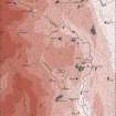
NGR NT 07214 04122
Datum OSGB36 - NGR
Permalink http://canmore.org.uk/site/48372


- Council Dumfries And Galloway
- Parish Kirkpatrick-juxta
- Former Region Dumfries And Galloway
- Former District Annandale And Eskdale
- Former County Dumfries-shire
NT00SE 12 07214 04122
(NT 0721 0412) Mote (NR)
OS 6" map, (1957)
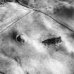
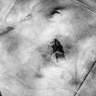
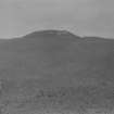
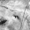
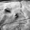
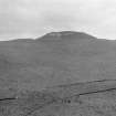
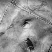
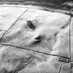
Motte (Feachem 1956) Coats Hill: An apparently artificial earth and stone mound on a natural eminence, 16' high and 40' x 30' over the level summit, with a projection to the W at a slightly lower level for some 24'. There is a trench at either end of the mound. Along the sides, where there is no trench, there are indications of dry stone work. There is a slight parapet at the E end.
RCAHMS 1920, visited 1912; R W Feachem 1956.
A motte, generally as described. The ditch, at the W end of the mound, is almost totally filled in and no trace of stonework was seen on the N and S sides.
Resurveyed at 1/2500.
Visited by OS (D W R) 5 September 1973
No change to previous field report.
Visited by OS (T R G) 23 August 1978
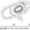
This motte, fashioned from a natural mound, stands to a height of 4.8m on its SSE side and its oval summit measures up to 20m from WSW to ENE by 19m transversely. At its base on the ENE, there is a ditch up to 5m broad and 3.5m deep and, on the WSW, a terrace which is overlain by a later field-bank. Rubble is visible in a series of eroded sections on the WSW, NNE, E and SSE sides of the motte summit and two fragments of 14th-century glazed pottery were recovered from that on the E.
Visited by RCAHMS (IMS), 6 June 1990.
RCAHMS 1920; R W Feachem 1956.
Scheduled as 'Coats Hill, motte 480m NE of St Margaret's... the remains associated with an Anglo-Norman timber castle...'
Information from Historic Scotland, scheduling document dated 13 March 2010.
(Symbol centred NT 07214 04122). Motte [NAT]
OS (GIS) MasterMap, April 2010.
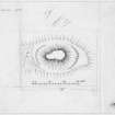
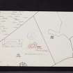
Measured Survey (6 June 1990)
RCAHMS surveyed the motte at Coats Hill on 6 June 1990 with plane-table and self-reducing alidade at a scale of 1:500. The plan was redrawn in ink and published at a scale of 1:2500 (RCAHMS 1997, Fig. 202).
Note (1997)
NT 0721 0412 NT00SE 12
Listed as motte.
RCAHMS 1997.

